I’d just like to clarify something: MPs are reappearing even when the imported car park point has been deleted or converted? I need to be sure before I fire it across to Waze…
Definitely reappearing when a point has been deleted. Definitely reappearing when there is now an area car park. Not sure whether it makes a difference whether the area is original (so the point has been deleted) or whether the area results from point conversion.
Ian
I’ve experienced that they have reappear for both scenarios.
I’ve experienced both.
Does “on-street” extent to car parks such as the one here, where the bays themselves are NOT on-street, but where they’re all directly accessible from the adjacent road?
On the one hand I’m thinking probably yes just from the point of view of how similar such car parks are in terms of their physical nature compared with true on-street bays, but on the other hand it would then mean that quite a lot of parking places (and particularly ones in touristy areas like this where Wazers may be most wanting to know where parking can be found) may end up not being added to the map at the moment, which isn’t going to provide a good end user experience.
I think the first question is, what are were trying to do?
Are we trying to map car parks? In which case I think we should not map this particular example. I see car parks being off-road areas.
Or are are we trying to map all places where people can park? in which case I think we should map not just this example, but also any line of marked parking places on the drivable surface of the road. Which we certainly haven’t been doing so far.
I don’t claim to know the answer, merely posing the question.
I’ve had them reappear after conversion to an area but on further analysis not all were named to reflect a parking area in the title. Most were just named after the closest street as I hadn’t updated the name. Not sure if the script is clever enough to look at the name though?
Funnily enough, this is almost identical to another place that ditchi & I discussed before I finished the guidelines. At the time, I thought it wasn’t worth posting here - and I guess I was wrong. :oops:
I would personally describe this as on-street parking. It’s slightly more separated than just bays painted on the road, but it is still on the road, accessed directly from the road and has no access roads of it’s own. It’s on-street parking - but at 90° to the road instead of parallel.
In terms of how Waze works, I’m pretty sure this will fail to work properly if it is mapped as a car park. The separation isn’t sufficient for a phone to determine you have entered the “car park” and there will be no PLR segment for you to drive onto, or be given directions onto.
At the UK meetup, Waze dropped some hints about on-street parking being the next phase. My expectation is that it will be implemented in a typically stupid Waze fashion, without the necessary options to make it useful across the world - and won’t show up for a year or so. But, until they do something about on-street parking I would say to definitely not map something like this.
If there are no massive objections, I’ll add something like “Car parks without an area separated from the road and PLR segments should not be mapped”.
This is the key point which convinces me that parking on or alongside roads should not be mapped.
Hi,
Got to see what waze says: https://www.waze.com/forum/viewtopic.php?f=8&t=203799&p=1499867#p1499867
Des. . . ![]()
Would anyone like to explain why a Staff edit needs approval, never mind that half the details (highlighted) can’t or don’t exist in the available options to editors ![]()
This at least proves that the Public / Private option is / was there somewhere.
This is the first PUR request I’ve heard about for a parking lot - and I sincerely hope it is the start of a trend.
I was absolutely furious to find all the imported parking lots had been imported straight into the map as places. By far the preferred method would have been to have them imported as PURs: this would mean they would not have polluted the app, forcing us into widespread removal of private lots. Instead, each PUR would have required the action of an editor to make it “live”.
Waze have, at least learned from this debacle. The next round of imports (not the UK!) is going to import all parking lots as PURs.
As for the private/public option. As I think I mentioned, this did appear very briefly in the editor. If it had remained there, the Parking Project would have gone a good deal more smoothly and caused far less frustration for us all.
As for the operators: I suspect that, somewhere, there is an existing database table containing a vast number of operators. The problem is that it has apparently not been linked up to the UI, so we have no choices to select. Perhaps it might be worth trying to update a place through the app and see if any operators are listed there?
There were none - and I eventually remembered to do this! :oops: :lol:
A new point added to the first post, along with some “hidden” explanation. :mrgreen:
Looks like Waze are once again reopening MPs closed for Car Park input as a point from approx 5 days ago.
Also how long should we wait after reporting bad car parks to HQ before deleting them :?:
Getting Car parks awaiting approval now.
Wouldn’t be so bad but they’re adding residents parking at apartments, parking at Travelodge, etc.
Just a couple of recent examples in Edinburgh.
Be careful with assuming hotel parking is solely for residents. I’ve noticed a fair number are actually Pay & Display, though who would choose to pay the extortionate prices :!:
Barrier into the car park gave it away, though I know what you mean. There’s a town centre Asda near me that’s P&D.
I’ve been wasting my time . . .
I have been stoically responding to Car Park Map Problems: reviewing the problems according to the guidelines; adding car park area polygons where appropriate; moving the round access point thingy to the nearest entry point (or choosing one of several); naming the polygons, using the name on the car park ‘Point’ where it is correct - which it isn’t always - only substituting 'Car Park for ‘Parking Lot’, as we are not all 'Murcans; deleting car park ‘Points’; drawing in ‘Parking lot roads’ where needed and appropriate; marking the MP as ‘Solved’ and saving the whole job lot. That’s about right, isn’t it?
Not a quick job. It must take at least four minutes to go through all those stages and there are dozens and dozens to be dealt with.
What happens then is that after a few days (3 or 5 seem to be favourites) the MP is re-issued, with no clue as to what might be wrong. Except, mysteriously, some of the polygons I remembered drawing have been deleted, though not all. Of those remaining I can see nothing wrong, so have been re-closing the MPs as ‘Not identified’ (which is untrue).
But I have found a solution:- I have turned OFF the ‘Map Problems’ layer. My time is too important to me to waste it in this way and Waze, with its badly thought-through, “The computer says no” car park project can, if you’ll excuse my directness, fuck right off.
Has anyone else had issue with the address of imported/updated car parks?
I believe there may be an issue with Waze filling in the house number of the car park address based on any numerals it finds in the address of the source data. I’ve seen this several times now where the car park is on a classified road with a road number in the street name.
Here’s an example: 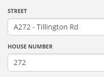
I’ve generally seen a number and road name in the house number box, I’ll keep an eye out on classified roads now though.