Thanks, Denys. I’ll be counting on the help of the folks in Paraíba to get familiar with the state. I hope to contribute to keeping Waze up to date in the region.
Good afternoon, everyone
Just stopping by to request SM for Paraíba and I’ve already filled out the form.
Hello everyone! Just letting you know that I’ve requested an expansion of my AM area via the form. I’ve been working in my current area since July '25 and haven’t been traveling much, which limits my contributions. The goal of the expansion is to contribute to map improvements in the cluster of cities between João Pessoa, Guarabira, and Campina Grande, focusing on general corrections, house numbering, handling URs, and creating and updating points of interest.
Looking forward to it and thanks.
It’s great to have you join us to make the map of Paraíba better every day!
The polygon for the Paraíba area needs a review, as nearly half of the beaches are outside the area.
Good afternoon, @marxmr !
It is not a “problem” just for the State of Paraíba!
Soon the SMs’ areas will be “corrected”!
I cannot specify a date!
Best regards!
Good evening everyone!
As specified in the Area Request form, I requested an adjustment and expansion of my current editing area. In the case of João Pessoa, the polygon initially released was quite limited and ends up cutting off some parts of the city.
Hi everyone, good afternoon!
Regarding the request above, I had only requested an adjustment to the AM area in João Pessoa, where the previously released polygon didn’t cover the entire city. But the group of Champs who handle that part informed me that I already met all the requirements and suggested I apply for an SM area, which wasn’t something I was aiming for. It was approved a few days ago, and the editing area was released yesterday.
So, I’m at your disposal for whatever is needed, but I should warn you that I’m the least experienced among everyone. Therefore, I’ll stay focused more on editing and will calmly study the SM duties to start acting more actively later on.
Good evening, @ivaldonm!
Congratulations to the newest SM of the State of Paraíba!
You’ll gain experience over time by consulting Wazeopedia, interacting with other editors, using the forum, etc…
I wish you success! Best regards and happy editing! 
Congratulations, Ivaldo! If you need any help, just let me know!
@denysdgcf, @pedaleiro_cwb (Renato), and everyone else, thanks for the support and I’ll definitely reach out and interact whenever I need to. Let’s keep focusing on improving the map.
Congratulations, @ivaldonm. Your participation will be a great help in updating the state maps.
Congratulations on the SM @ivaldonm!
And may new experiences come with edits across the state of PB 
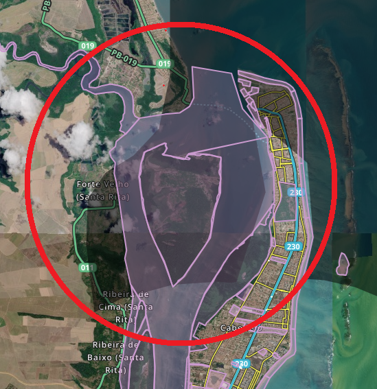
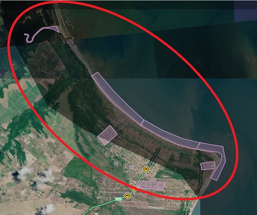
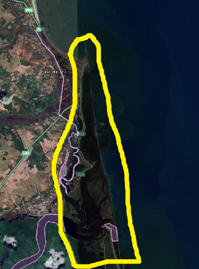
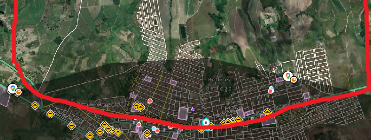
@denysdgcf Any updates here? Now that I have an SM area, I can clearly see these distortions, as shown in some cases below, which go well beyond the coast, as @marxmr mentioned.
- Cabedelo/João Pessoa:
- Lucena:
- Baía da Traição:
- Padras de Fogo:
- Jaçanã - RN (but inside PB):
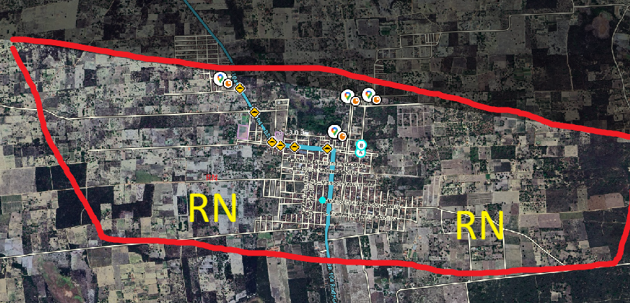
So there are many areas we don’t have access to. I know fixing it is a bit of work. But as it is, the areas “hidden” from the editor will never evolve.
This issue also happens in other states, and some areas end up being “in the dark.” Since many editors use area filters to handle URs, sometimes some in these locations without this coverage go weeks without a response from an editor.
Good afternoon, @ivaldonm!
This SM area issue is “old” and unfortunately there is no timeline for a solution!
Best regards.
Good evening @denysdgcf, do you know whose responsibility it is to fix this? I understand it shouldn’t be like this; we have to fix it to ensure the least amount of distortion possible. Depending on the tool used to adjust the polygon, I can help.
Good evening, @ivaldonm!
This issue is being addressed, but we don’t have a solution yet. We took the state polygons from IBGE and expanded the borders by a certain number of kilometers (automatically through a library written in Python), which solves most cases, but not all.
So, we are reviewing each of these polygons and making the necessary adjustments manually. The problem is that this is labor-intensive. Once that’s done, we’ll have to send the adjusted polygons to the staff for the final correction.
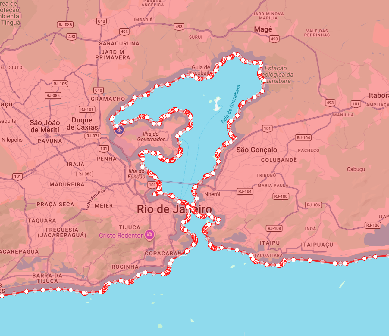
The original and expanded polygons are available at this link in WKT format. If you or any other editor can help, we would really appreciate it! One example of a polygon that, even with the expanded borders, wasn’t 100% resolved is the state of RJ, as a section of the Rio-Niterói bridge and Paquetá Island were left out.
Good morning, @georgenqueiroz
Couldn’t a case like this include the entire bay, since there’s a highway and ferry routes in it?
Yes, we could do that. The problem is that we have to do it manually on a case-by-case basis across all states.
Note that the expanded polygons were generated automatically, but the corrections need to be made manually, which makes the work time-consuming.