I agree that airstrips with any sort of facilities shared among the users are worthwhile to map as APs, and in the lower 48 that will probably be most of them. So to the extent there’s a debate it is coming down to what in the lower 48 will be a very small number of airstrips.
Waze has apparently had an Airport Area Place for this community since the basemap import (when it was probably an “Arprt”). The current layout of the Area Place follows the general idea of mapping the runways. I think dfw_gis’ proposal would be to map the taxiways as well.
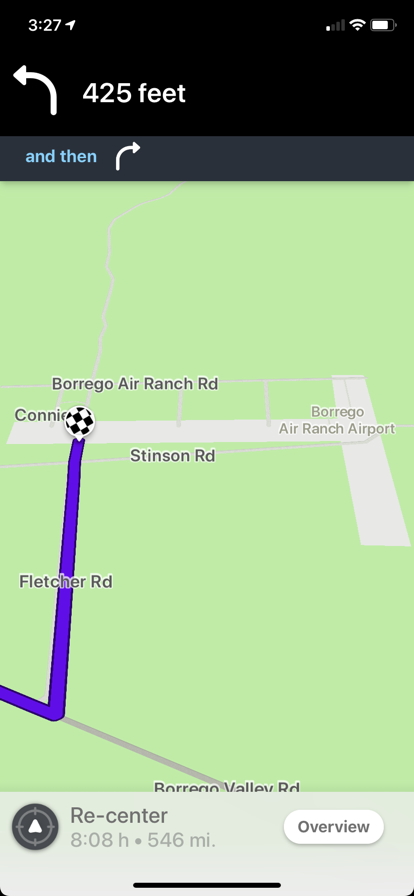
This AP satisfies my proposal’s requirements for an AP, because the “surrounding open space” is NOT “largely or completely invisible to passing traffic”. HOWEVER I think it shows how quirky it is to map an AP for such a facility where all the actual airport trappings except the runways themselves are on private residential property AND – this is the big one I think – the “Runway” road type fails to display.
To my eyes this is a fairly unsatisfying AP. Without the runway displaying, it looks like a small residential community that has a weirdly-shaped AP on top of it. If the airstrip for this runway was not out where drivers could see it, but rather hidden behind the back fences of residential properties, I think it would be even more unsatisfying. In that latter case – what MacroNav brought up – I’d agree that such an AP would not be a win for drivers.
What we really want for these locations may be to have runways display :mrgreen:
I took a look and that is an interesting place. Moreso the strange appearance in the app caught my attention as well. I’m curious if the rendering is in part to A) there also being an expansive state park overlaying the facility and B) that airport, the runways, and the surrounding road network needs a bit of work. I don’t have EA over there or I would have taken a stab at it but I’ll attach a screenshot of what I would change it to, ostensibly the RPZ or Runway Protection Zone. Even the roadways have a Hold Bar helping delineate a border. I’m wondering if cleaning this place up and replacing the Runways altogether would improve the display. It would be a good test subject nonetheless.
You are trying to solve one off scenarios with an all encompassing national policy. There needs to be a level of local discretion. In the case of Borrego this unique due to the multiple areas layered here. Again something working with the regions leadership can probably be solved.
If a place has gone through the process of obtaining an FAA identifier then it should be an airport and subsequently an area place. If we want to better define what is included with the area place then great. Maybe something simple shared resources to support the operation of the airfield. resources will carry from area to area on how we can determine if something is common or private property and at the end of the day since we don’t have a corresponding satellite view of the location in the app small variables on the borders will not impact the end user.
I took 5 minutes to pan around the map in a few states and easily found FAA points that I believe shouldn’t be mapped at all - and thankfully they have not yet been. But per the current guidance they should be. Does that make sense?
I agree that this shouldn’t be mapped because there is no sign/evidence of an airport/airstrip anywhere.
I agree that this shouldn’t be mapped because there is no sign/evidence of an airport/airstrip anywhere.
I agree that this shouldn’t be mapped because there is no sign/evidence of an airport/airstrip anywhere.
I agree that this shouldn’t be mapped because there is no sign/evidence of an airport/airstrip anywhere.
I agree that this shouldn’t be mapped because there is no sign/evidence of an airport/airstrip anywhere.
I don’t see an issue with this one be mapped, there is an obvious airstrip
Someone mapping all but the last one should be asked where the actual evidence of an airport/airstrip is.
As with any place mapped, no place should be mapped just because GIS-L or even a website shows something there. If there is no airport/airstrip then it shouldn’t be mapped.
Just because McDonald’s has a place listed on their own website with an address and phone number, etc, doesn’t mean you map it if the McDonald’s does not exist in real life.
This is ostensibly the crux of what I am believing whether or not I conveyed it correctly. If there is nothing there, in this case, a legitimately defined airstrip and/or associated support facility then no area place should be applied. As for the Borrengo example my only effort there was to offer what I could see from the pavement markings to address the topic of housing / airport boundaries and also what I thought could be contributing to the display issue and have always stood by the premise there will be exceptions to the rule and also local leadership can and should be involved with those scenarios. As with any of the guidance, there is an opportunity to improve understanding as we encounter more anomalies to better define our practice.
Airports are somewhat near and dear to me and not only have provided a living for me but also are a subject I cut my teeth upon when I started volunteering with Waze. It’s a topic I can get involved with since I don’t know enough coding to keep up with the script folks
I don’t understand why there is so much support for cluttering the map & search results with “airports” that are only potential landing strips. When I search for airport, in my mind only three results should appear - the municipal and regional airports in my area. But instead I see a bunch of landing strips, and the actual airports are lost in the results on another page.
What do you think is the percentage of people using the Waze app that are looking for directions to an airport providing scheduled service, versus those looking for a landing strip in the middle of a farm for a crop duster that is used once or twice a year? These two types of facilities should not be treated the same.
If there is a business we add a place. If there is no business, we do not add a place. If there is no business entity providing airport services, it should not be a place - it’s like an RPP. It’s private, not for use by anyone else, stay out, you don’t belong here if you don’t already know where it is.
I’m pretty disillusioned with this process. I thought it was a simple request to ask that editors show some reflection before adding these places to the map.
I’m sorry that you feel disillusioned. But, the app should be for everyone. Not just non-pilots. If a strip is not there, it shouldn’t be mapped. But, if it is there, it should. If I am a private pilot and I search for an airport I want to go to a place where I can go see planes. Should I be removed from using Waze because I don’t just search for our regional airports? Of course not. The idea of Waze is to be used by all. I think we have all agreed with the idea, if there is an FAA identifier, someone has taken the time to make sure that airport qualifies as an airport. And, if that airport doesn’t actually exist, it’s our job as editors to remove it from the map. Like the McDonald’s example above. It has to actually be there to count. But, if it’s there, we add it. My 2 cents.
It seems like the trouble really is with private airports, meaning four-digit FAA identifiers that are usually simple grass fields without any storage of planes, maybe used by a farmer or two to launch crop dusters. Sean, as a pilot would you find those results valuable? They do exist but may not be easy to see from imagery. I’ve mapped a couple around me, but they do show up in category search, along with general aviation airports and larger commercial facilities, as MacroNav pointed out. Could we draw the line between public and private airports, or am I oversimplifying?
This needs to be said in big bold letters: Large Area Places are NOT primarily for the benefit of people routing to them!
We do NOT put parks on the map to benefit nature lovers, lakes on the map to benefit sailors, or schools on the map to benefit students. They may benefit those people of course. But that is a secondary benefit, NOT their primary purpose.
If it WERE their primary purpose, then we would be using large Area Places for sprawling office complexes, famous neighborhoods, and expansive private estates. We don’t, even though Waze is for the people who go to those places too.
The primary purpose of large Area Places is to serve as orientation for drivers passing near them.
The question being discussed is NOT about whether pilots are worthy of keeping “their” Area Places. I have a world of respect for pilots and the astonishing level of dedication and skill piloting requires, but that is neither here nor there.
The question is whether a handful of practically nonexistent, minimally maintained, invisible-from-nearby-roads, backyard airstrips with no facilities whatsoever, surrounded by personal residential properties and/or wilderness, serve as orientation for drivers passing nearby.
By that standard, I believe the specific Alaska airstrips linked by MacroNav fail, and I continue to propose my guidance addition as follows.
Sean, although I’m not a pilot, I am an enthusiast, and have spent a lot of time in the right-hand seat of Cessnas flying throughout Alaska. If it is any place that you can go to see aircraft, I’m all for it being mapped. What I’m against mapping is places that you cannot go to, because they are somebody’s yard and/or farm, do not allow transient parking, and are used infrequently.
Yes, in some cases this may be a judgement call, perhaps indicated by the apparent level of use of the field, number of hangars and aircraft visible, if there are no other indicators such as google businesses. We could potentially do searches of the FAA database through airnav.com for private unattended fields with no services and no or few aircraft based at the field.
To address one of my concerns, perhaps we could have a naming standard so that private fields that are mapped have a distinct and uniform name, not including “airport” in the name. So when scrolling through the list of results, at least it’s easier to identify true public airports.
“Private Airfield - Anderson Lake 0AK1”
“Private - Anderson Lake Airstrip 0AK1”
It seems that many (not all) agree there’s a line to be drawn across which an airport doesn’t qualify to be mapped as an area place. As DL said, area places are for orientation, but they’re also searchable and navigable, we should consider both sides of that coin. The line seems to be at least whether an airport can be used by the public (not whether it is publicly owned). Having visible facilities is also helpful for orientation, but those usually go hand-in-hand. Fly-in communities, which are mentioned on the road types page BTW, are just one type of airfield that is usually for private use.
If an airport has a four-character identifier, don’t map it. All the examples given of places that shouldn’t or should be mapped, on both sides of the argument, fit this distinction.
Purely for the purpose of thinking out loud and clarification the four character/private use fields would A) Not be mapped at all, or B) Mapped as an airport but not as an area place allowing it to be searched, or C) mapped as a Place Point but under a different place category? In the case of B or C could we utilize the naming convention MacroNav mentioned or something of the like?
Purely thought for discussion. I think this is a much needed conversation and thank all who have put in their thoughts on the subject.
There needs to be some clarification of the four letter vs three letter designation of airports. Specifically IATA (3 letter) ICAO (4 letter).
The normal three letter designation that most people use [DCA - Ronald Reagan Washington National Airport, LAX - Los Angeles International Airport, JFK - John F Kennedy International Airport] are publically known ones.
But each has a four letter designation in the ICOA. KDCA, KLAX, and KJFK.
So should it be map as an area if there is a three letter IATA code? Most but not all US airports have ICAO codes that are the IATA with a K in front.
We’re not talking about IATA or ICAO codes. All of the borderline kinds of airports being discussed here are too small to have either. We’re talking about FAA identifiers, which are given to any aviation-related facility in the US. All public-use airports have three-character FAA identifiers. The bigger ones have three-letter identifiers, which are usually the same as the IATA code if one is given. The smaller public-use airports have two numbers and a letter. Private-use airports, whether they are jointly owned for fly-in communities or singly owned for use by one person or family, have four-character FAA identifiers, with two letters and two numbers. A lot of the info on airport codes is already in the airport page. Anyway, I was proposing last night to just say we don’t map any private-use airports.
However, after looking up a bit more, there are a few private-use airports that might be noticeable for orientation or used as destinations, mainly within large fly-in communities like Jumbolair, so we need to provide for those. My idea for guidance goes closer to what DL proposed, but since many private airports are not fly-in communities, it should be more general, and I think we can agree that all public-use airports should be mapped, no matter how small. So how about adding this section at the top of the page:
I think this can be removed since it is cover in the next sentence.
I also think if the airstrip and/or aviation-related structures are visually obvious from satellite, they should be mapped. Here is my suggested changes.