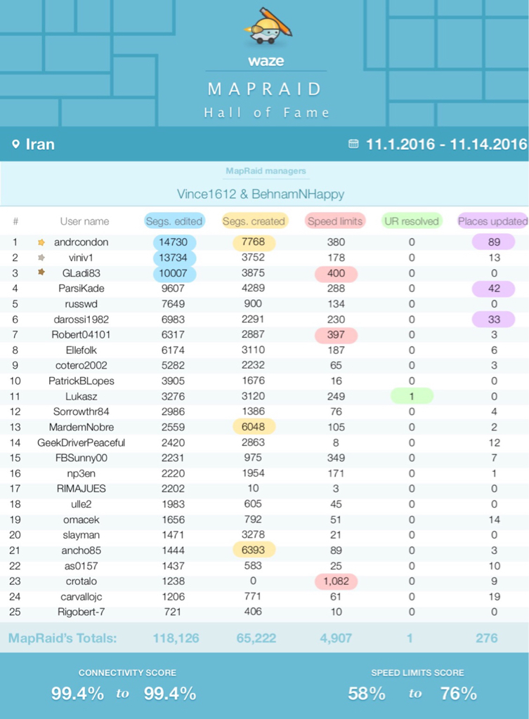
Mashhad Mapraid editing instructions & Rules
Posted: Wed Oct 19, 2016 11:47 am
In this topic we discuss about editing rules needed for Mapraid in Mashhad & Iran.
This is work in progress, please check this page again before the MapRaid begins for updates!
MapRaid dates:
From November 1st to November 14th 2016
Location:
https://i.imgsafe.org/7840171f85.png
Where to register:
 Subscription Form for Mashhad Mapraid
Registration will be closed on 25th October 2016
Editing Goals:
1. Major Highways:
- Roads have at least 3 lanes in each direction.
- No stop signs or Red lights.
-Separated directions of travel.
2. Minor Highways:
- Roads have at least 3 lane in each direction.
-But they have junctions or stop signs
- Usually we name this kinds of roads as Boulevards.
3. Ramps:
- All entrance and exits between highways.
4. Primary streets:
- All roads that have at least 2 lane in each direction.
5. Streets:
- All roads that is residential and open to public. They usually have only 1 lane in each direction.
6. Private roads:
- Roads inside industrial areas.
- limited access like residents only roads.
7. Parking lot Roads:
- Used for inside parking lots (only one row is enough for entering and exiting)
- Petrol stations.
There might be local lanes parallel to Highways:
For major highways local lane set as primary street.
For minor highways set as street.
Naming Roads & Abbreviations:
1.We use dual language names in Iran to be suitable for locals + tourists & Also make TTS work which is divided by dash "-"
Example :
Mirdamad Blvd - بلوار میرداماد
2. Streets & Primary streets: Since double language make street name long Don’t add “Street” or “Avenue” in the name of roads.
3. Minor Highways: “name” Blvd - بلوار نام
4. Major Highways: “Highway name” Hwy - بزرگراه نام
5. There are roads that are divided and they have officially "West, East, South and North in their names. Example: we have "Sarv West" & Sarv East" and should be written this way: Sarv E - سرو شرقی and Sarv W - سرو غربی
Roundabouts:
Roundabouts should also be drawn as simply as possible, with single 2-way segments for each connecting road. Pairs of 1-way entry and exit segments are not really necessary (if it only divided near the roundabout) . If you have an opportunity to remove these when rebuilding a roundabout, please do so. They will look much better on the client.
https://wiki.waze.com/wiki/images/f/f9/ ... oDivRd.png
Steps for redoing a roundabout:
* Delete roundabout and 1-way "V"s
* Drag main 2-way segments to the centre
* Draw new roundabout
- Small and mini-roundabouts should be drawn as large as possible. Any with a radius much less than 10m will not be visible on the client, so aim to get them close to this size if you can.
Naming Roundabouts:
To aid navigation instructions, roundabouts should typically remain unnamed (Just City Name)- where the client comes across a segment with no name it will use the next named segment as the next named instruction whilst retaining any turn signals.
If the roundabout does have a proper, signposted name, then this can be labeled using a 'Junction/Intersection' type landmark that fills the centre of the roundabout.
-If two entry and exit segments share the same junction on the roundabout, the exit will not be counted when entering at that junction. Entry and exit segments should always be connected via separate junctions.
Rules:
1. Mass editing is forbidden (the exiting map has huge mistakes already suffer from previous mass editing).
2. Entering Speed limits for streets & ramps are forbidden.
3. Don’t name Ramps & Roundabouts (Just City name).
4. If URs problem is unclear for you Please let local editors or those map raiders that are able to read & write Persian handle those since they can better communicate with local users.
5. Don’t separate directions of Streets & Primary streets that are divided by just cement blocks.
Example:
https://uploads.tapatalk-cdn.com/201610 ... cb96ed.jpg https://uploads.tapatalk-cdn.com/201610 ... b79c24.jpg
Mashhad's Municipality Map
Street veiw is availave also
Map Raid Group Chat:
Telegram app will be used for Group chat between raiders.
It supports nearly all platforms: iOS, Android, Windows Phone, Windows & MacOS.
- Invitation link will be sent to raiders before map raid start.
Last Update 24/Oct/2016 08:00 GMT
This is work in progress, please check this page again before the MapRaid begins for updates!
MapRaid dates:
From November 1st to November 14th 2016
Location:
https://i.imgsafe.org/7840171f85.png
Where to register:
Registration will be closed on 25th October 2016
Editing Goals:
- Fix a huge number of mistakes in in junctions which made map untrustable.
Example: all directions in this point is allowed which should not be.
https://i.imgsafe.org/7833859893.png - Missing Roads & disconnected Roads
https://i.imgsafe.org/7816f56f2d.png - Road Types.
- Road Names.
1. Major Highways:
- Roads have at least 3 lanes in each direction.
- No stop signs or Red lights.
-Separated directions of travel.
2. Minor Highways:
- Roads have at least 3 lane in each direction.
-But they have junctions or stop signs
- Usually we name this kinds of roads as Boulevards.
3. Ramps:
- All entrance and exits between highways.
4. Primary streets:
- All roads that have at least 2 lane in each direction.
5. Streets:
- All roads that is residential and open to public. They usually have only 1 lane in each direction.
6. Private roads:
- Roads inside industrial areas.
- limited access like residents only roads.
7. Parking lot Roads:
- Used for inside parking lots (only one row is enough for entering and exiting)
- Petrol stations.
There might be local lanes parallel to Highways:
For major highways local lane set as primary street.
For minor highways set as street.
Naming Roads & Abbreviations:
1.We use dual language names in Iran to be suitable for locals + tourists & Also make TTS work which is divided by dash "-"
Example :
Mirdamad Blvd - بلوار میرداماد
2. Streets & Primary streets: Since double language make street name long Don’t add “Street” or “Avenue” in the name of roads.
3. Minor Highways: “name” Blvd - بلوار نام
4. Major Highways: “Highway name” Hwy - بزرگراه نام
5. There are roads that are divided and they have officially "West, East, South and North in their names. Example: we have "Sarv West" & Sarv East" and should be written this way: Sarv E - سرو شرقی and Sarv W - سرو غربی
Roundabouts:
Roundabouts should also be drawn as simply as possible, with single 2-way segments for each connecting road. Pairs of 1-way entry and exit segments are not really necessary (if it only divided near the roundabout) . If you have an opportunity to remove these when rebuilding a roundabout, please do so. They will look much better on the client.
https://wiki.waze.com/wiki/images/f/f9/ ... oDivRd.png
Steps for redoing a roundabout:
* Delete roundabout and 1-way "V"s
* Drag main 2-way segments to the centre
* Draw new roundabout
- Small and mini-roundabouts should be drawn as large as possible. Any with a radius much less than 10m will not be visible on the client, so aim to get them close to this size if you can.
Naming Roundabouts:
To aid navigation instructions, roundabouts should typically remain unnamed (Just City Name)- where the client comes across a segment with no name it will use the next named segment as the next named instruction whilst retaining any turn signals.
If the roundabout does have a proper, signposted name, then this can be labeled using a 'Junction/Intersection' type landmark that fills the centre of the roundabout.
-If two entry and exit segments share the same junction on the roundabout, the exit will not be counted when entering at that junction. Entry and exit segments should always be connected via separate junctions.
Rules:
1. Mass editing is forbidden (the exiting map has huge mistakes already suffer from previous mass editing).
2. Entering Speed limits for streets & ramps are forbidden.
3. Don’t name Ramps & Roundabouts (Just City name).
4. If URs problem is unclear for you Please let local editors or those map raiders that are able to read & write Persian handle those since they can better communicate with local users.
5. Don’t separate directions of Streets & Primary streets that are divided by just cement blocks.
Example:
https://uploads.tapatalk-cdn.com/201610 ... cb96ed.jpg https://uploads.tapatalk-cdn.com/201610 ... b79c24.jpg
Mashhad's Municipality Map
Street veiw is availave also
Map Raid Group Chat:
Telegram app will be used for Group chat between raiders.
It supports nearly all platforms: iOS, Android, Windows Phone, Windows & MacOS.
- Invitation link will be sent to raiders before map raid start.
Last Update 24/Oct/2016 08:00 GMT