US Regions and Coordinators
Posted: Fri Apr 12, 2013 4:28 pm
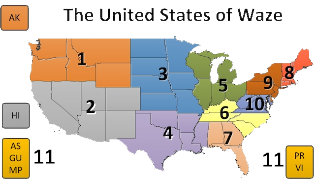
US Regions (Regions updated December 2016
https://storage.googleapis.com/wazeoped ... nators.png
US Regional Coordinators (RCs updated February 2023)
1. Northwest (NWR) - (RC) turbomkt, (ARC) FzNk: Washington, Oregon, Idaho, Montana, Wyoming, Alaska
2. Southwest (SWR) - (RC) ottonomy, (ARC) jemay, (ARC) tonestertm: California, Nevada, Utah, Arizona, New Mexico, Colorado, Hawaii
3. Plains (PLN) - (RC) Bretmcvey, (ARC) ehepner1977, (ARC) SunnyRaynbows: Iowa, Kansas, Minnesota, Missouri, Nebraska, N. Dakota, S. Dakota
4. Southcentral (SCR) - (RC) karlcr9911, (ARC) sketch: Arkansas, Louisiana, Mississippi, Oklahoma, Texas
5. Great Lakes (GLR) - (RC) JoeRodriguez12, (ARC) GizmoGuy411, (ARC) ldriveskier: Illinois, Indiana, Michigan, Ohio, Wisconsin
6. South Atlantic (SAT) - (RC) xanderb, (ARC) dfortney, (ARC) whathappened15: Kentucky, N. Carolina, S. Carolina, Tennessee
7. Southeast (SER) - (RC) itzwolf, (ARC) driving79: Alabama, Florida, Georgia
8. New England (NER) - (RC) orbitc, (ARC) SanzClew, (ARC) banished: Connecticut, Maine, Massachusetts, New Hampshire, Rhode Island, Vermont
9. Northeast (NOR) - (RC) orbitc, (ARC) PhantomSoul, (ARC) RussPA: Delaware, New Jersey, New York, Pennsylvania
10. Mid Atlantic (MAR) - (RC) nzahn1, (ARC) ct13, (ARC) ldriveskier: District of Columbia, Maryland, Virginia, West Virginia
11. Territories (ATR) - (RC) nnote: American Samoa, Federated States of Micronesia, Guam, Marshall Islands, Mariana Islands, Palau, Puerto Rico, Virgin Islands
(Note: ATR = American Territories Region)
Waze Community Manager
Brettc0
https://storage.googleapis.com/wazeoped ... nators.png
| Please use map key numbers only where this map is visible. Do NOT use the numbers in messages, signatures, or in other forms of information exchange without the map visible |
1. Northwest (NWR) - (RC) turbomkt, (ARC) FzNk: Washington, Oregon, Idaho, Montana, Wyoming, Alaska
2. Southwest (SWR) - (RC) ottonomy, (ARC) jemay, (ARC) tonestertm: California, Nevada, Utah, Arizona, New Mexico, Colorado, Hawaii
3. Plains (PLN) - (RC) Bretmcvey, (ARC) ehepner1977, (ARC) SunnyRaynbows: Iowa, Kansas, Minnesota, Missouri, Nebraska, N. Dakota, S. Dakota
4. Southcentral (SCR) - (RC) karlcr9911, (ARC) sketch: Arkansas, Louisiana, Mississippi, Oklahoma, Texas
5. Great Lakes (GLR) - (RC) JoeRodriguez12, (ARC) GizmoGuy411, (ARC) ldriveskier: Illinois, Indiana, Michigan, Ohio, Wisconsin
6. South Atlantic (SAT) - (RC) xanderb, (ARC) dfortney, (ARC) whathappened15: Kentucky, N. Carolina, S. Carolina, Tennessee
7. Southeast (SER) - (RC) itzwolf, (ARC) driving79: Alabama, Florida, Georgia
8. New England (NER) - (RC) orbitc, (ARC) SanzClew, (ARC) banished: Connecticut, Maine, Massachusetts, New Hampshire, Rhode Island, Vermont
9. Northeast (NOR) - (RC) orbitc, (ARC) PhantomSoul, (ARC) RussPA: Delaware, New Jersey, New York, Pennsylvania
10. Mid Atlantic (MAR) - (RC) nzahn1, (ARC) ct13, (ARC) ldriveskier: District of Columbia, Maryland, Virginia, West Virginia
11. Territories (ATR) - (RC) nnote: American Samoa, Federated States of Micronesia, Guam, Marshall Islands, Mariana Islands, Palau, Puerto Rico, Virgin Islands
(Note: ATR = American Territories Region)
Waze Community Manager
Brettc0