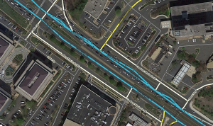
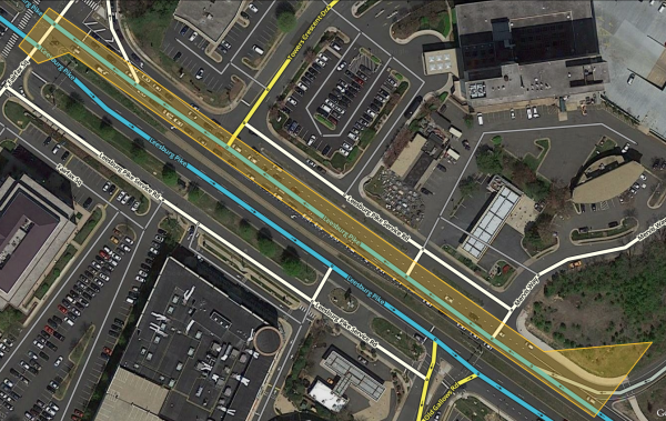
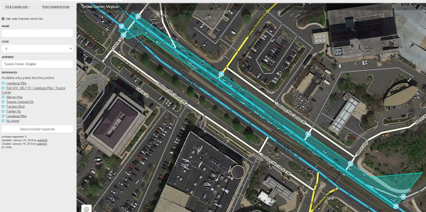
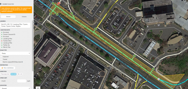
Kartografer (talk | contribs) (internal turn restrictions) |
Kartografer (talk | contribs) (added data examples) |
||
| Line 50: | Line 50: | ||
|4}} | |4}} | ||
With a junction box the connections from A to F, and from A to E are being measured separately, the traffic jam for the red cars turning at D does not have a negative effect on the blue cars going straight through D. Their ETAs are being recorded separately. | [[File:Venice-Lincoln right turn.png|right|200px]][[File:Venice-Lincoln left turn.png|right|200px]]With a junction box the connections from A to F, and from A to E are being measured separately, the traffic jam for the red cars turning at D does not have a negative effect on the blue cars going straight through D. Their ETAs are being recorded separately. | ||
This effect can be seen in the images to the right. During the evening rush hour there is an average 30-second difference to cross the segment that enters the box from the northeast, depending on whether the route turns left or right one segment later. Without the junction box no difference would be detected here, and routing would be less accurate. | |||
===Controlling turns=== | ===Controlling turns=== | ||
| Line 103: | Line 105: | ||
*Routes through the junction box that are prohibited by red turn restrictions between segments within the junction box are not considered. | *Routes through the junction box that are prohibited by red turn restrictions between segments within the junction box are not considered. | ||
== | ==Turn arrow tooltip== | ||
[[File:Wme_turn_override_hover5.png|250px|right]] The | [[File:Wme_turn_override_hover5.png|250px|right]] The [[Map_Editor_Interface_and_Controls#Turn_arrow_tooltip|turn arrow tooltip]] for junction box connections has at most five elements: Voice prompt, Instructions, Restrictions, Switch Route (when applicable), and Difficult turn. If none of these elements is changed, Waze will simply use whatever settings exist for the underlying turns through the nodes that make up the junction box connection. | ||
{{User:Kartografer/Far turn instruction}} | {{User:Kartografer/Far turn instruction}} | ||
Revision as of 22:06, 2 March 2023

A junction box (JB) is a tool used to group separate junction nodes and the segments between them into a single big junction for improved data collection, routing control and navigation instructions. In simple terms, junction boxes tell the routing server, “Although the segments coming into here are connected in a few separate places, they should be treated as if they are all connected together at one place." Because of this, junction box connections provide an extra layer of information on top or instead of the information associated with individual nodes, segments and turns.
A note on terminology
As development around junction boxes has progressed, different words have been used to describe them and their parts. In the underlying data of the Waze Map Editor junction boxes are called bigJunctions, and each allowed route from an entry segment through a junction box to an exit segment is called a crossroadConnection. The newer and similar path entity is called a pathConnection in WME data. The connections between the entry and exit segments of both junction boxes and paths are also known as far turns in some parts of the WME interface; just as a normal turn crosses one node to another segment, a far turn crosses multiple nodes and intermediate segment(s) to another segment. Although editors have often called these parts of a junction box "paths", for clarity this page primarily uses the term "connection" when referring to the routes through junction boxes, with "far turn" used as a synonym when referring to certain parts of the user interface.
Overview
The junction box enables a complex intersection or interchange comprising multiple segments to be treated by the routing server somewhat like a single junction node with multiple entry and exit segments. Considering a complex intersection as a single entity has several beneficial properties:
- Traffic speed data for each connection through the junction box can be collected separately.
- Turn restrictions can be separately controlled for each far turn through the junction box.
- Voice prompts can be separately assigned for each far turn through the junction box.
- Turn instructions can be separately assigned for each far turn through the junction box.
- Lane guidance can be separately assigned for each far turn through the junction box.
Junction boxes are stored on the routing server. They are not visible in the client or on the live map. Junction boxes do not affect the search engine; the origin or destination of a route may be contained in a junction box.
Junction boxes are only considered by the routing server when the route fully traverses through the junction box. Routes that start or end inside a junction box will use the underlying segments for routing and instructions. This means that junction box speed data, route restrictions, and instructions that have been overridden by the junction box will not be used by the app in these cases. Examples where this could occur are:
- When a route's destination is inside the bounds of a junction box.
- When a route's origin is inside the bounds of a junction box.
- When a route is recalculated inside the bounds of junction box, such as after a missed turn.
- When the user experiences loss of Internet connection and must rely on client-based routing.
Improving data collection

Waze routing servers use junction box traffic data instead of the underlying segment and node traffic data, though Waze continues to collect both sets of data.
A complex intersection can skew turn delay transition speed data. At first glance the following example seems like a pretty simple intersection, but if it usually experiences heavy traffic this intersection could be collecting bad data.

Assume that all the roads are two-way and all turns are enabled. Consider the drivers going from A to E, and from A to F, when there is a traffic jam for the left turn (at point D), but traffic going straight through D is flowing fine.
Without a junction box, the traffic from point A to point C is considered to be the same for both the red and the blue cars. The same statistical data is gathered and the average speed skews the ETA for everyone. The turn delay data is only different for the red and blue cars on the one segment before the turn at D, from C to D.

Adding a junction box solves this problem. With a junction box, historical and real time data are collected separately for each one of the possible routes through the intersection - all 12 of them.
- A ➡ B
- A ➡ E
- A ➡ F
- B ➡ A
- B ➡ E
- B ➡ F
- E ➡ A
- E ➡ B
- E ➡ F
- F ➡ A
- F ➡ B
- F ➡ E


With a junction box the connections from A to F, and from A to E are being measured separately, the traffic jam for the red cars turning at D does not have a negative effect on the blue cars going straight through D. Their ETAs are being recorded separately.
This effect can be seen in the images to the right. During the evening rush hour there is an average 30-second difference to cross the segment that enters the box from the northeast, depending on whether the route turns left or right one segment later. Without the junction box no difference would be detected here, and routing would be less accurate.
Controlling turns

Junction boxes permit disallowing, partially restricting or marking as difficult turns complex intersections. Without a junction box, controlling complex turns formerly required adding artificial segments and/or resorting to unrealistic road geometries.
Fine-tuning instructions

Both junction boxes and paths enable editors to give drivers much more specific instructions through complex intersections than are otherwise available. This could be telling the driver to user only the rightmost of three right-turning lanes, because their route has another right turn in quick succession. Or it could involve showing and reading just one of multiple exit signs present at a freeway exit. Far turn instructions and far lanes are powerful tools to improve the navigation experience in Waze.
Where to use
Junction boxes are suitable only where their functions are required. If problems are easily solved with other features such as paths or simple turn restrictions, a junction box should not be used. Appropriate reasons to use a junction box:
- To prohibit a route on the same exit path when there are two different entrances, where using a regular turn restriction would also prohibit other routes that should be allowed.
- To prohibit U-turns over median segments between divided roads at four-way H or # intersections.
- To collect more granular data on traffic that backs up unequally across different lanes of a road through multiple junction nodes, due to conditions like heavy weaving between entrances and exits on a freeway, or busy left turns through an intersection with long cycle times.
- To ensure proper routing and data collection through intricate intersections containing multiple short segments.
- To correct routing issues or improper turn instructions in roundabouts.
Junction boxes provide the ability to fine-tune voice prompts, visual instructions, TTS and lane guidance through them. However, paths also offer this functionality and can be nested, and junction boxes block their use. Therefore, a junction box should not be used purely to alter navigation instructions or lane guidance. These are secondary uses of a junction box that is already required for the reasons listed above.
An exception can be made for roundabouts. Altering the voice prompts of all the turns through the roundabout can be accomplished with one round box rather than many paths, and since lane guidance is currently not supported in roundabouts, there is no concern about blocking paths for lane guidance that might originate from junctions outside the roundabout.
Drawbacks
Certain things cannot be done to segments and nodes that are part of a junction box without first deleting the junction box. These include:
- Changing a segment's direction between two way and one way
- Moving a junction node across the boundary of a junction box
- Adding or deleting a junction node inside a junction box
- Adding, deleting, connecting or disconnecting a segment inside a junction box
For these reasons, junction boxes should not be used for every intersection. Where they are used, turn information should be applied to node-based turns rather than junction box far turns, if possible, to avoid rework if the junction box needs to be deleted in the future.
Note that for many years it had been impossible to cut or merge a segment that enters or exits a junction box; the JB had to be deleted first. This is no longer true. However, if you encounter a permissions error after cutting or merging one of these segments, try disallowing one of the JB far turns that exits at the cut/merged segment. This will usually let the save happen, after which the far turn can be allowed again and saved.
Editing
A Junction box is created by selecting Junction box from the draw segments menu (Shortcut key J). Click at one vertex of the junction box. Continue to click at each vertex of the box until the box surrounds all the junction nodes of the intersection. Double click to complete the box.
- The boundaries of the box cannot be changed once created. If you need to change the shape of the junction box, you must delete it and create it again.
- Before creating a junction box at an intersection, make sure that there are no incorrect turn restrictions including U-turns. Routes through the junction box that are prevented by existing turn restrictions cannot be enabled in the junction box.
- The connections through a junction box can be edited when it is selected. To select a junction box, click on it.
- When the junction box is selected, the left pane will show the potential connections through the junction box as illustrated above. Clicking the check box next to each connection path toggles between enabling or disabling routing between the indicated entry/exit pair.
- The left pane includes a button to "Select included segments." Clicking this button will select all the segments with both ends in the junction box (these are the segments that are not considered for ETA routing purposes).
- The left pane includes a name box and an address. A name can be added to the name box and the address may be edited. However, currently the name and address of a junction box has no effect.
- To delete a junction box, select the junction box and click the delete button
 (Shortcut key Del).
 - Changes to junction boxes (and adding new junction boxes) require a tile update to affect routing.
- If a junction box is deleted and then recreated using the same segments before too much time passes, the Waze routing servers can use the previously stored junction box data for any segment IDs that have not been deleted.
Effects In Editor
Junction boxes can only be edited by editors of at least rank 4. Junction boxes appear in the Waze Map Editor when the Junction Boxes layer is turned on; the two pieces of paper in the upper right of the map editing area. Junction boxes appear as a polygon around all the junction nodes of an intersection.
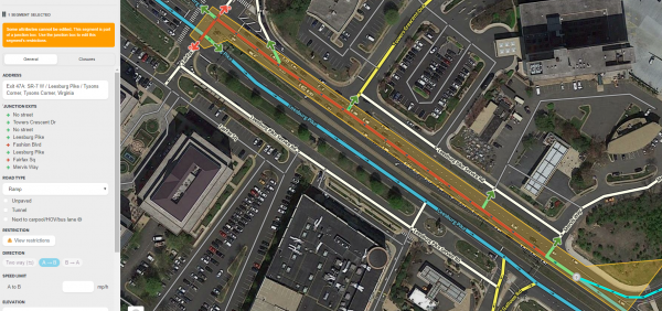
All segments that enter the junction box are only partially editable. Selecting a segment that is part of a junction box results in a message: "Some attributes cannot be edited. This segment is part of a junction box. Use the junction box to edit this segment's restrictions." For further details on which attributes can be edited and which cannot, see when to use.

Selecting the junction box causes the left pane to display the junction box properties. The properties show the editor that created the junction box with the date and the editor of the last update to the junction box. If changes are needed to the junction box or segments associated with the junction box, contact the identified editor or other rank 4 or higher editor in your area.
The left pane shows potential entry/exit pairs with a check box ticked for each pair enabled for routing. Note that only entry/exit pair paths which are fully visible on screen are displayed. So make sure you can see the whole boundary of the JB to be sure you're getting a full list of entry/exit pair connections in the left pane.
- Routes through the junction box that pass through a single junction node (and do not cross any JB internal segments) are not controlled by the JB. Instead, they are controlled by simple turn restrictions.
- Routes through the junction box that are prohibited by red turn restrictions between segments within the junction box are not considered.
Turn arrow tooltip

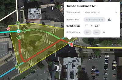
The turn arrow tooltip for junction box connections has at most five elements: Voice prompt, Instructions, Restrictions, Switch Route (when applicable), and Difficult turn. If none of these elements is changed, Waze will simply use whatever settings exist for the underlying turns through the nodes that make up the junction box connection.
Just as with turns through nodes, voice prompts, turn instructions and TTS can be customized for far turns through junction boxes and paths.

Please note: Although turn instruction information is added by hovering over the exit arrow of the far turn, in most cases it is applied at the entrance. Think about what the driver sees at the entrance when adding turn instruction information to paths and JBs.
Voice prompt

If a voice prompt override is added to a far turn, then all internal Waze selected voice prompts are removed, and the voice prompt is announced at the first node of the path or JB connection. As of February 2023[update] (except for in some in-car interfaces like Android Auto) the name of the exit segment is displayed and spoken by default, just as the turn arrow tooltip indicates, even there is a named segment before it inside the path/JB.
If a voice prompt override is added to a far turn, and lane guidance has also been set up where the voice prompt is given, the lane guidance will be displayed with the voice prompt. Make sure to check the lane guidance when adding a voice prompt (and anything else, really) to far turns, and add far lanes if necessary.
Instructions
A voice prompt can also be added in the Instructions panel. If all other fields in this panel are blank or unchanged from their default values, the voice prompt override will function alone, just as if it had been added directly from the turn arrow tooltip. On paths the voice prompt can only be changed in the Instructions panel.
All other elements of the Instructions panel function together (the various visual instruction fields and TTS). They are usually given at the first node, like the voice prompt, but if the criteria of the 50-meter rule are met, they are given at the next full turn instruction. They require a full turn instruction to have an effect; if the driver is not told to turn, exit, continue, etc. where this information would be given, no visual instructions can be displayed there, and no auditory instructions can be spoken.
TTS
Even though the TTS (text to speech) box will show the name of the exit segment in gray, this name may not actually be what's spoken. If the name of the exit segment is required in TTS, be sure to confirm it by clicking the TTS field (turning the text from gray to black), then clicking Apply, before saving the far turn instruction.
Usage of far turn instructions


Where they are used, turn instructions should be applied to simple, node-based turns rather than far turns (JBs and paths), if possible, to avoid rework if the junction box or path needs to be deleted in the future. Reasons for customizing far turn instructions include:
- Multiple signs are displayed for a single turn, with each sign pertaining to the next turn (see example at right). Customize the visual instructions and TTS, but usually not the voice prompt, so as not to suppress the next turn instruction.
- A sign pertains to a straight movement through a divided road intersection, and a continue straight instruction is necessary. Customize the visual and TTS instructions, and add a Continue voice prompt.
- One or more divided roads meet at a roundabout, and normal instructions are desired and/or there are different signs at different entrances that pertain to the same exit. Customize the visual instructions and TTS, and/or add turn right/continue/turn left/U-turn voice prompts, as necessary.
- Segments connect in an intersection in such a way that, with realistic geometry and node-based turn instructions, incorrect voice prompts are given. Customize the far turn's voice prompt.
Conflicts
Far turn voice prompts conflict with all near turn (single node) voice prompts within the connection. If a voice prompt is set on any of the near turns that make up a connection, the far turn's voice prompt has no effect.
Far turn visual and/or TTS instructions only conflict with near turn instructions where they are given (usually on the first node, or on the first turn where the far lanes 50-meter rule is active). Visual and/or TTS instructions can be used on the other turns in paths or junction box connections. Be sure to remove conflicting information from near turns when working with far turn instructions.
For more information on turn instructions, see the turn instruction page.
Restrictions
Partial restrictions, including time-based restrictions, can be added to junction box far turns just as to normal node-based turns. In fact, when a junction box is created, any partial restrictions that exist on segments and turns within the junction box are automatically copied into the applicable junction box far turns, making these JB turn arrows yellow. This is similar to how drawing a JB over nodes with full turn restrictions causes applicable JB far turns to have red arrows. After a junction box is created, all restrictions are controlled by hovering over its far turn arrows and making changes there rather than on underlying segments or turns.
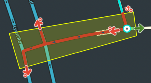
Internal turn restriction
The turn restrictions or time-based turn restrictions for junction arrows on segments that enter the junction box are visible on the node within the junction box. Selecting an entry segment displays normal turn restrictions just like selecting a segment that is not in a junction box. There are also turn restrictions or time-based turn restrictions on each far turn arrow. This is because the junction box has copied all internal restrictions onto the far turns. The same is true for time-based restrictions on entry, internal and exit segments.
Switch Route
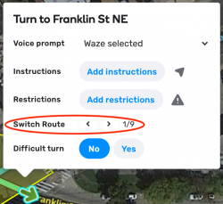
There can only be one route from a specific entrance to a specific exit in a junction box. In cases where there is more than one routing option available, then the Switch Route control will appear. This will allow you to specify the route taken by the far turn through the junction box by clicking the forward or back arrows. If you wish to allow a far turn, make sure the route follows the desired segments and directions and is green. All other routes through the box for the same entry/exit pair are disallowed, even if they would be allowed by the segments and turns under them. If the route selected in the route switcher is red, all routes through the box for this entry/exit pair are disallowed.
If there is only one route available in the junction box, the switch route selection will not appear. It may take several clicks to get to the desired route, potentially hundreds or even thousands for routes with many internal interconnected segments.
Difficult turn
Difficult turns (including time-based ones) can be applied to junction box far turns the same way that they are applied to normal turns. They cause a routing penalty to be applied to the far turn if the user has difficult turn avoidance turned on, which is the default setting for all new users at least since 2019. Please refer to the difficult turn section for editing directions.
Difficult turns may be useful for far turns that are legal but directly contradict guide signs and/or require quick weaving through multiple lanes of traffic, such as entering a highway from the right and then quickly exiting to the left.
Far lanes

Simple lane guidance works well in many places but not all of them. Far lanes were developed in order to provide editors greater control over unusual and complex lane situations. Far lanes may be added to the far turns in the lanes tab for any segment that enters a junction box or path, unless that far turn includes a segment of a roundabout.


Far lanes can be added by rank 4 and higher editors. The first phase of their development was to enable them for junction boxes, which is known as far lanes phase 1 or FL1. The second phase of their development was the release of the paths feature, which is known as far lanes phase 2 or FL2. Although junction boxes and paths have some differences, far lanes work identically whether in a path or junction box connection.
Far lanes have a few effects that can enhance lane guidance, described in the following subsections.
Preferred
One of the most important effects of far lanes is the ability to map preferred lane guidance. This type of lane guidance shows drivers that they should use a particular lane or lane(s) that are a subset of the lanes involved in a turn. For example, there may be two lanes that turn left at an intersection, and then the two lanes split immediately in two different directions. If a driver's route is to turn left where there are two left turn lanes, then immediately keep right using one of those two lanes, the driver would prefer to be in only the second lane from the left, as taking the leftmost lane would require the driver to quickly switch lanes. This is shown in the animated example to the right for the left turn to I-270 S.
Notice that for the turn to I-270 N only the second lane from the right is given, but it is not shown with a full instruction; instead this lane is a view only lane that reads "Continue straight" below it. This is also a preferred lane, but it isn't shown at the same place as a turn instruction. In addition, notice that the left turns are given 500 feet ahead of the driver, with the same lane picture. These different behaviors of far lanes are more fully explained in the next subsection.
Display behaviors
The lane or lanes added to a far turn are treated in one of four ways in the Waze client:
- They are "view only", silently shown at the end of the entry segment with "continue straight" text.
- They are shown after the end of the entry segment, along with the next visible, audible turn instruction, as part of a combined, single intersection.
- They shown immediately at the end of the entry segment with a visible, audible turn instruction.
- They are not shown at all.
View only (> 50 meters to next turn)


If there is no turn instruction for a far turn on the first node after the entry segment, and there is either:
- No turn instruction on any subsequent nodes of the far turn within 50 meters past the first node, or
- Lane guidance before the next turn instruction,
and the far lanes are either:
- Not straight, or
- Straight, with the "View only" setting applied,
then these far lanes will be displayed at the end of the entry segment with "Continue straight" under them.
This can be useful to provide clarifying, advance notice to drivers, telling them "don't turn here, but keep going in this lane, then turn at the next intersection." This is how these far lanes are used in the first far lanes example, for traffic going to Executive Pkwy and I-270 N.
However, this can also cause unexpected results, since a turning lane arrow with "continue straight" under it often appears self-contradictory, and if this behavior happens where the turn is coming up in the same intersection, it could even lead people to miss their turn. Be sure to understand this effect, and if single-intersection far lanes behavior is desired instead, read on.
Single-intersection heuristic (< 50 meters to next turn)

Similar to the heuristic used to combine the lane guidance for separate turns through H and # intersections, there is a different heuristic used with far lanes to ensure that a complete lane picture is shown at every turn through an intersection with multiple nodes and segments. The turns at multiple nodes in a single intersection are tied together, but with less stringent requirements and better control by editors. This is especially useful where an intersection has at-grade connectors, there are multiple short segments to the next turn, or its geometry is skewed too much from perpendicular to meet the requirements for H and # heuristic to work. Another advantage of this far lanes heuristic is that the lanes are only set on the entry segment, and the full lane picture is visible in WME in one place.

The single-intersection heuristic is applied to both left turns toward SR-161 W and I-270 S in the first far lanes example. It is also applied in the example to the right. After lane guidance was removed from the next segment, the driver simply sees one left turn instruction in the proper place.
Far lanes are only combined for an intersection, or "pushed" past the first node to the next turn, if all of the following criteria are met:
- No turn instruction is given at the first node, just as with view only far lanes.
- Voice prompts and view & hear straight lanes are considered, on both near and far turns.
- The distance to first node that has a turn instruction within the far turn must be less than 50 meters (164 feet).
- No lane guidance may be present on the segment immediately before the instruction.


If far lanes are pushed, any visual turn instruction, TTS or voice prompt set on the far turn is also pushed to the location of the next turn. This can cause some unexpected results, so be sure to understand where an instruction will be displayed when using far lanes.
A segment may not support both the non-far-lanes divided-road heuristic combination and far lanes in the same direction. If you decide to add far lanes to an intersection that has the older heuristic combination, be sure to remove any subsequent lane guidance on the median segment and, if applicable, past the AGC. The far lanes must be on the first segment that enters the intersection in order to work properly.
Immediate, full instruction

Just as with standard lane guidance, if a full turn instruction occurs (either because the next segment is not the best continuation, a voice prompt is used to force an instruction, or view & hear straight lane(s) are set on the far turn) at the end of a segment, any far lanes that this turn comprises are shown with the turn instruction.
The lanes tab in the example to the right shows two standard right turn lanes followed by lanes set on several different far turns. If a route follows any of the right far turns, such as to I-10, the applicable right turn lane is shown at the A end of the selected segment.
Not shown
If there is no turn instruction for a far turn on the first node after the entry segment, and there is either:
- No turn instruction on any subsequent nodes of the far turn within 50 meters past the first node, or
- Lane guidance before the next turn instruction,
and the far lanes are straight with the "Waze default" setting applied, they will not be shown.
In the example above, the three straight far lanes that continue on Veterans Blvd are not shown in the app for movements eastward through the junction box. This is the same behavior as expected with standard lane guidance. In general, setting far lanes that aren't shown to drivers only happens in junction boxes, since with paths you can choose which individual connections to make, and there is no point in making a path that has no effects in the app.
Editing notes


Far lanes may only be added to far turns on junction boxes and paths. There are a few things to take note of:
- As of February 2023[update] there is no automatic assignment of lane directions to far turns as to near turns; the lane arrows must be set manually.
- Set far lane arrows based on what the driver sees around the end of the segment selected; far turn arrows merely show which routes the turn information applies to, not where the lanes are shown in the app during the drive.
- Make sure that every lane is checked somewhere, and every route through the end of the segment has lanes assigned either on near or far turns.
- After saving, make sure that the lane guidance does not have any error indicators, especially if not all lanes are assigned to near turns. Any possible "escape" from lane guidance will result in an error that invalidates the entire set of lane guidance for all the turns from the segment.
- The fix for such "escape" lane errors is to "capture" them with lane guidance, either using shorter paths or assigning more lanes to turns.
- It is not always necessary to assign every lane to a near turn, but it is good practice where possible, for the above reasons.
- As of March 2023[update] the LaneTools script indicates errors in lane guidance if not all lanes are assigned to near turns, but this is inevitable in many situations with turn lanes.
Further far lane resources
- Waze staff how-to document for phase 1 far lanes (junction boxes)
- Waze staff how-to document for phase 2 far lanes (paths)
- Waze staff (Gil) office hours presentation on JB far lanes
- Waze staff (Gil) office hours presentation on path far lanes
- WME far lanes recorded demo by whoaitspete (US Champ)
For more information on lane guidance, see the lanes page.
Errors when editing
- Max size - The length of a junction box cannot exceed 0.01° latitude and 0.01° longitude. In terms of distance, the north-south linear limit is always 1110m (0.01°), while the maximum east-west linear limit varies depending on your latitude, because the length of a longitudinal degree decreases as you travel further from the equator. In the southernmost part of the continental US, 0.01° longitude translates to about 1010 m; along the Canadian border (49° N), however, 0.01° longitude is about 730 m. So the max size of a JB in Key West is about 1110 m x 1010 m (N-S "height" × E-W "width"), but along the Canadian border the max size of a JB is 1110 m x 730 m (N-S "height" × E-W "width").
- No overlapping - A junction node cannot be included in multiple junction boxes, nor can a segment be included in both a junction box and a path.
- One connection minimum - A junction box must include at least two junction nodes and one segment, with at least one allowed connection (green or yellow far turn) through them. Otherwise, there is nothing to control. A junction box with only one junction node cannot be saved.
- Sixteen connections maximum - As of February 2023[update] no more than 16 routable connections can pass through a single-junction node within a junction box. A save error occurs if a junction node has more than 16 connections. This does not count fully restricted connections, where the far turn arrow has been made red, as this actually deletes the connection. It is unclear whether the system counts near turns (single-node U-turns or other turns that do not cross the JB's internal segments) as part of this total. In some situations, WME will say that the sixteen-connection limit has been exceeded, even where the number of visible allowed far turns is lower, even as low as twelve. In other situations, WME will save a junction box that has more than sixteen far turns and near turns through a node, even as high as twenty.
- Note that having a U-turn enabled on a two-way segment inside junction box will increase the number of connections and can lead to the saving error. If you encounter this message, look for connections to disallow.
- Adding artificial complexity to work around the sixteen-connection maximum is not recommended. If such a workaround is required, please consult with your state manager or regional coordinator.
- Non-navigable segments - Junction nodes within a junction box can't be connected to non-drivable road types unless connected by a virtual node. Connected non-drivable road types will generate a save error and should be disconnected from the junction within the junction box. This includes railroads.
Final Checks
- Check every connection from every entry segment.
- For the final configuration, if you do not want routing from a given entry to a given exit segment, the connection through the box and its far turn arrow must be red.
- For the final configuration, if you do want routing between these two segments, the connection must be green, with a green (or yellow) far turn arrow.
- It is recommended to save the final configuration of the junction box, then either soft or hard refresh the map. After these steps recheck every route from every possible entry segment to each exit segment. This is recommended because occasionally during the save process WME will set an incorrect route and rechecking each route through the junction box will catch these errors.
Select example use cases


