Welcome to the forum and bigger Waze Community!
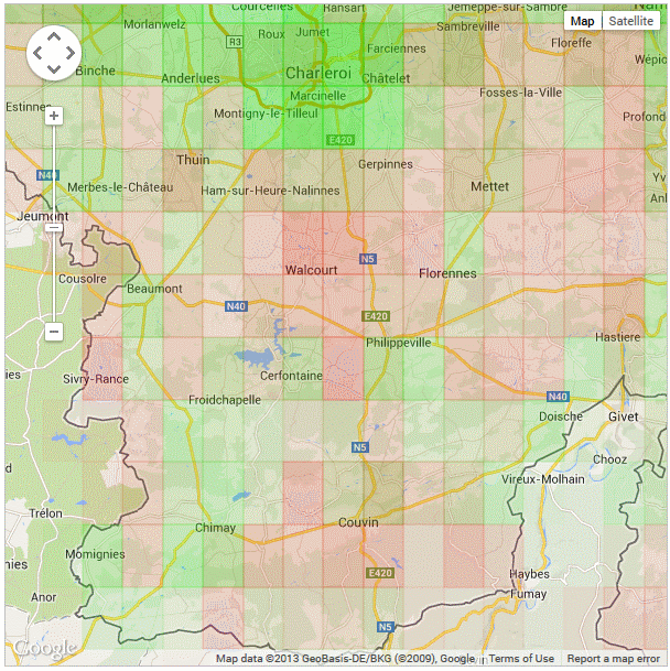
We can surely use some extra help in Wallonia, as you can see, still some work to be done there…
Great you already have that much of edits, in just 2 weeks!
In your enthousiasme, i hope you also took some time to read the wiki and learn something about the guidelines for editing in Belgium/BeNeLux?!
The last couple of weeks the updateprogress of the map has had some hard times… There are periods where we get a daily update of the map, there are weeks it takes a couple of weeks… But overall, i think we can’t complain, since other nav apps have maps that are like 1 year old or so…
I’m guessing/hoping we will have a new update in the next couple of days…
Your edits don’t have to be approved, but it would be great if you got in touch with a level 3, 4 or 5 editor (Area Managers, Regio Managers or Country Manager), to help you coach your edits…
Would be great if you learned fast, are engaged (in editing, learning, and building the community) and became an area manager!
For the map updates (and other waze server related things) check http://status.waze.com/ to see when the latest update was (delays in the map update are announced there as well)
Bonjour Je suis actif en région du sud de Liège. Qui est le coordinateur pour ma région ?
Je suis prêt a faire quelques Kilomètres et éditer la carte (j’ai deja commencé), car il y a en effet quelques erreurs on manquements.
Il n’y a pas vraiement de coördinateur… mais si vous avez des problèmes ou des questions vous pouvez toujours nous contacter, ici, ou par Google Hangout…
Même si il n’y a pas d’area manager dans la zone , les priorités sont :
-Le nom des routes
-Vérifier et corriger les “turns restriction” (flèches vertes ou rouges) Petit astuces Appuie sur Shift + Z t’afficheras toutes les flèches rouges.
-Le réseau principale (Nationale et autoroute doit être prioritaire, normalement il est ± bon mais parfois quelques problèmes notamment au niveau du nom des sorties et accès.)
-Faire du KISS (Keep it stupidly simple) c’est à dire faire une map simple éviter les dédoublements de routes ect . . . y a un tuto dans le wiki.
-Et quand tu n’as plus de zone a éditer soit tu va faires un petit tour dans une zone fort rouge sur la carte pour l’éditer ou alors tu attaques les “landmark” zone de foret , rivière , lac ect…
Bref, Y a du boulot :lol:
Et comme dis steven en cas de problème un petit post sur le fofo avec un permalink de la zone litigieuse et on regarde.
We also discussed some of the language barriers here in the forum, which may be one of the reasons there aren’t that much french speaking people over here, and the community in the french speaking part has some more work to do.
So would be great to see you more over here, and maybe now and then help with the french speaking people…
Aucun souci, je peux faire tous mes post en francais, mais le problème en Belgique, c’est que peu de francophones parlent/comprennent le néérlandais et donc, on a le réflexe de l’anglais. J’ai le problème dans mon environnement de travail, j’ai pas mal de réunions qui se font en anglais pour cette raison. Je comprends assez bien à l’oral et à la lecture mais je ne parviens pas à tenir une conversation en néérlandais. Je sais, c’est triste, mais c’est la triste réalité de notre pays
So, if I can assist anyone in French, I guess I can do it - as soon as this is falling into my scope of knowledge !
Thanks, this is impressive How can you guys generate this ? and also, what green means ? What is taken into account to define that an area is now green ?
It’s not supported by Waze, so we can’t tell you a lot on how it works…
But it works based on how many segments are in the area and how many of them have a name + streetname. So how higher the ratio, how harder te green… How lower the ratio, how darker the red…
It doesn’t totally represent if the map is finished, but it at least gives some kind of direction