GeoApophis and I were having a discussion in an UR I created about the Road type classification of Dakota Dr. in Fargo from University to 12th Ave Bridge. Copied below is the discussion so far:
(To note: I was wrong about the street parking criteria, that’s just one that was used as a default no-no back home in MD)
Secondly, if you look at section 3.1.4 (table 3.2) you see that one of the characteristics of “minor aterials in urban areas” is
. Since Dakota dr. penetrates the Roosevelt neighborhood and is lined with apartments and homes, I believe this disqualifies it from being a major arterial.
To wit, I know that you are just following the Fargo maps and I hate to be picky on this but I live in this neighborhood and I got hit by a car while on my bike on Dakota dr. last fall because of someone going too fast. It needs to be downgraded. After seeing the Fargo maps, I have also contacted the City to see if I can get the road re-classified.
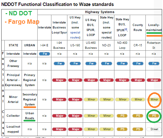
Regarding FHWA and its definitions on functional classification and how it applies to roadways, this is at the national level. The FHWA has given/allowed State (DOT) and local municipalities to handle non-highways and freeways at their discretion. This means that NDDOT and its towns/cities can classify each road how they feel is necessary.
When looking at functional classification in ND and in the cities, you must first understand how DOT and the cities define the classification type. Do not pay any attention to the actual road type in waze. It tends to confuse many.
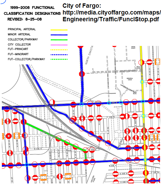
What the city of Fargo has classified as principal/minor arterials and collectors is based on the capacity of the road (how many cars it can handle), the number of intersections, speed, and length of the road. The classification also shows where the city prefers to have its traffic flow through.
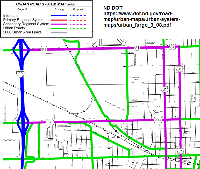
We follow what NDDOT and the available maps show regarding classification. If Fargo labeled a road as minor arterial, then it will be classified as such. That means that Fargo felt that this road was necessary to be classified as a minor arterial because it met the criteria or for future upgrades.
Many states, during the implementation phase of FC, had the same issue. The main problem that arose was that some editors would focus on the name of the waze road type (major/minor highway, primary street) and use that as the basis for what should and shouldn’t be used. That is why the FC table was made. Since each state has different use of classification, individual FC conversion tables were made for states that wished to deviate from the standard list. That is what ND did. You can see that table here.