I currently commute from Hemel Hempstead to Stokenchurch. It’s quite a long drive, but I’m moving closer soon so it’s fine. ![]()
I could just take the M25>M40 both ways and have it done in 40 minutes, but the M25 doesn’t work properly in the morning so I have to go another way around (A41 to Tring, then A and B roads to Stokenchurch. There is a single instance of a single track road right at the end of the trip, but I often ignore Waze and go round depending on the weather). Coming home the M25 just about functions as a road, at least in the direction I’m travelling, so I can just do M40>M25 with no problems.
As one of the alternatives to these two routes, Waze always suggests some other crazy routes going down millions of country lanes, but I never ever want to do that, because they’re country lanes. Simply put: I never want to go on single track roads with passing places unless it’s absolutely necessary. Even through I drive a clapped out old Celica, I do not want to pretend I’m driving a rally stage. Waze, however, seems determined to take me on them, thinking they’re an easy and fun drive around the USA and not what they really are: a great way to practise squeezing between a 4x4 BMWs and a hedge, uphill, or nearly slamming into chav kids going 50mph round a blind corner whilst I’m doing 20. I once had some utter idiot in a 4x4 BMW not reverse far enough back to his passing place (he made an effort, I guess?) which meant I had to skirt around him. My car was literally at 45 degrees to the horizon to get round this guy. (I have a broken nearside coil spring – I was dreading the drop back down to level territory and the inevitable snap. Thankfully it didn’t)
I understand that Waze is an American app, and so it’s rating go from pristine tree-lined streets to “4x4 fun dirt roads” with no inbetween, as that’s all they have over there, but can we not request some kind of inbetween category? I’d really like for these crappy roads to be marked as “single track roads” and also for an option to never go down them unless required.
Perhaps at this UK annual user conference that’s coming up you could take any visiting yanks for a drive down a “primary street” country lane and see how much they like it?
As an example route of these hellish drives: the other day, there was a problem on the M25 at the M40 junction point. Some accident causing lots of standstill traffic? Waze kindly routed around the problem. I don’t know if the accident happened before I set off at ~5:15, and therefore was going on this route the entire time, or if Waze redirected me whilst I was driving on the M40, but had I taken a look at the map before setting off I would have “noped” right out of it and just taken the opposite route to my morning one (go north on some B- and A-roads and back to the A41 by Tring). But I didn’t know what was happened until it was too late. I even tried to abort the mission mid way through, but Waze offered me no sane ways back to civilization, that I could see, so I had to continue on with the country-lane madness.
I don’t know how to link to a route, so I’ll just link to snippets. Note how many of these roads are marked as Primary Streets or normal Streets with 60mph speed limit. Granted, that’s the lawful truth of those roads as they’re national speed limit, but they’re definitely unsafe to drive at those speeds? Plus, a lot of them are unsuitable for goods vehicles and clearly say so with signs, yet they’re still “primary streets” in Waze.
The google streetview pictures are a bit misleading in some cases, as they were all taken in autumn/winter, and so they don’t show the true horror these roads represent in July, when they are all pretty much surrounded by tall, full, scrapey hedges. I could upload some dashcam footage if you want ![]()
-
M40 at Stokenchurch
-
A355 (N)
-
A40
-
Through Chalfont St Giles
-
Across the A413 on the B4442
-
Down more of the B4442
-
Turn of the B4442 onto Roughwood Ln (Which is unnamed segment in the editor?)
-
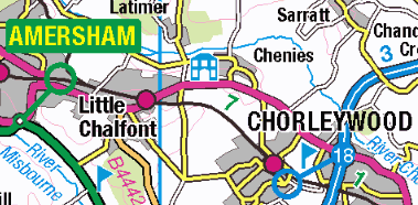
Pass Little Chalfont via Lodge Ln
-
More Lodge Ln to cross the A404. At this point, whilst waiting to cross the busy A404, I was frantically mashing “find route” to try and get back onto the M25… Instead I think all I succeeded in doing was making Waze take me through Belsize>Chipperfield>Kings Langley rather than Hogpits Bottom>Bovingdon>Hemel. I imagine it was the same sort of ride no matter which of those two routes I took.
-
So because of that Frantic mashing I go right on Latimer Rd
-
Up Chenies Hill
-
Through Belsize
-
Up Dunny Ln into Chipperfield.
-
And on past Chipperfield into the back-end of Kings Langley
edit: Sorry, some of the links work, but some don’t! When I open them up, they take me to the right place on the map but some don’t select the road in question. If I highlight the road and select perma-link, Waze gives me the same URL…