While being nosey in areas I have recently driven I came across this nicely drawn junction.
How pedantic should we be :?: Or should we work on ‘if it ain’t broke don’t fix it’ :!: This does need a little work on the turn restrictions is not modified to a single connecting road.
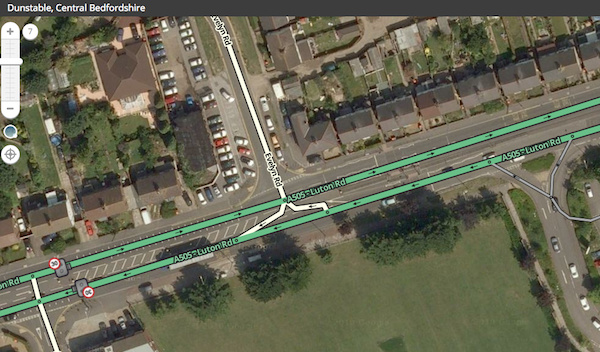
Simple is always better and if it ain’t broke is a rule of thumb generally. I’d be inclined to simplify it if I had the time to check and double check everything is correct when complete.
(Some caveats apply for correct routing instructions)
I’m not sure that road needs to be a split carriageway either (see other threads)
Sent from my iPhone using Tapatalk
Looking at the screenshot, turning right into the sideroad is pretty much still the same instruction, while turning right out of there may not have any instruction. The junction to the west looks much simpler, and will produce perfect instructions for all directions.
Zoom out to ~200ft, and you’ll see what the client sees in terms of map detail. Nothing.
https://www.waze.com/forum/viewtopic.php?t=132721
Less really is more.
Sent from my Wileyfox Swift using Tapatalk
I’ve used this junction many times, though not to turn right out of Evelyn Rd.
When I first started using Waze, the turn instruction from Luton Rd westbound into Evelyn Rd was keep right which is possibly why it was a split initially?
I can’t see why it needs to be 2 now, but if they’re kept, the turn right angle out of Evelyn Rd needs sorted.
On a side note, the aerials in the area are out of date which is why the roads don’t match in Tesco. Streetview is OK though.
So I’m happy to alter the junction to a single connecting road if the minor highway segments are downlocked to L2, to ensure turns are correct etc.
Was there a consensus on the split highway? It looks as though the entire length of A505 Luton Rd is regularly split by traffic islands and longer crossing points etc. I would lean towards leaving it split.
Segments unlocked as requested. There should be 2 disable turns when you’re done, assuming U-turns are prohibited here.
I’d suggest leaving it mapped as dual-carriageway, as it is a wide road and there are physical barriers in places, plus a one-way system at the west end.
All done. I would hope that the Waze u-turn prevention would cut in as the connecting segment is only 7m (half the length required) but I understand restricting the turns is a better safe than sorry approach.
:oops: I’m really sorry about all these cliché phrases today.
The parking lot road on the right looks extremely wrong!!!
Sent from my SM-G925F using Tapatalk
Why? If you are comparing the car park as mapped to the aerial view then you have just fallen into the trap of assuming the aerial view is up to date. :lol:
This is true. I guess the entrance has changed. I should not assume things like that as the aerial view where I am is outdated by years in some places
Sent from my GT-I9500 using Tapatalk
It’s always worth looking at the GPS tracks and then checking the date in StreetView. Luckily in the UK some area’s have 6 updates in StreetView so you can see how the area has evolved. In this case it looks like the car park entrance changed between Nov 2009 and May 2012.