Hi there,
Need some level 3 fluence applied to deal with a UR. A Wazer has commented that he was directed to “keep left” when leaving the A5 and going onto Lon Graig on the edge of Llanfairpwll. I presume this is because the angles are too shallow, although the only list I could find quickly suggested 45 deg was the divider and the Lon Graig one is apparently 49deg according to the Angles thingy. Looking at the map I would imagine the A4080 is also indicated as a keep left and both should be Turn left’s.
It’s all locked at 3 there so I can’t fix it…
Thanks
Martin
I think you’ve got the UR the wrong way round, although you have correctly identified the angles and instructions. ![]()
If you look at the purple Waze-provided route, you’ll see that the reported was heading south west: they were directed to “turn right” onto the A5 (because of the 49° angle) and then to “keep left” onto the A4080 (as you predicted).
Although the Lon Graig turn was over 45°, it was still rather close. I’ve tweaked both junctions now and you’ll see I’ve left them as much closer to 90°. Not only does this make things look a bit better in the app (which is pretty low resolution), but it makes it clearly visible in the editor, which is much better. Little kinks like this tell you that an editor has looked at the junction and very deliberately set the geometry to give the correct instructions. You can therefore move on & look for other things that need doing.
For example, in the collection of roads north of the A5 here, I can see at least 3 junctions that worry me that the angles may not give the intended instructions. Can you spot them? :lol:
I’m confused! The reporter told me they got the “keep left” going into Lon Graig, and the position of the UR would fit with them hitting the button after turning into Lon Graig. However, the angles that were there and the arrows on the waze trails fit your interpretation.
I’ve asked him to clarify and will also go looking for the needles to which you refer ![]()
The needles:
I’ve altered the feed into the parking lane at “Ty’n Caeau”?
I’m not sure about the meeting of “Lon Y Wylan” and “Lon Hedydd” (although I have joined the 2 ends of the latter together as they should be) - is that one?
One leg of “Bryn Bras” is at 45deg?
If there are others I need more clues - I’m only a humble level 2 remember!! ![]()
Sounds like you got 2 of them! :mrgreen:
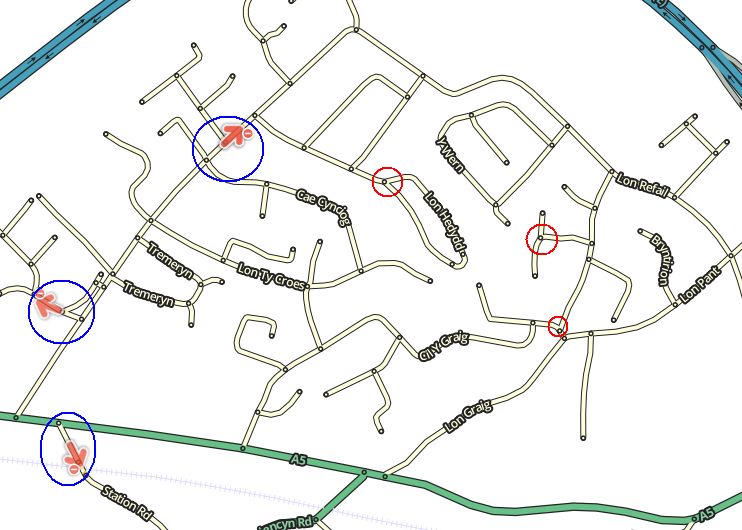
The red-ringed junctions look, at initial glance, like they might not have the proper angles to be sure they give the right instructions.
Also, the 3 red arrows circled in blue might not be correct. I’d certainly check them out in Street View to see if they’re correct.
I’ve tweaked the top 2 (which I spotted) but think the 3rd one is ok.
As for your Red Arrows - I’m sure you sneak them in when I’m not looking!
I’ve fixed 2 - one was were I tweaked yesterday - usually try to check everything twice! Done another but the one off the A5 I can’t changed - level 3 - but you’re right, it shouldn’t be red.
Martin
Fixed :mrgreen: