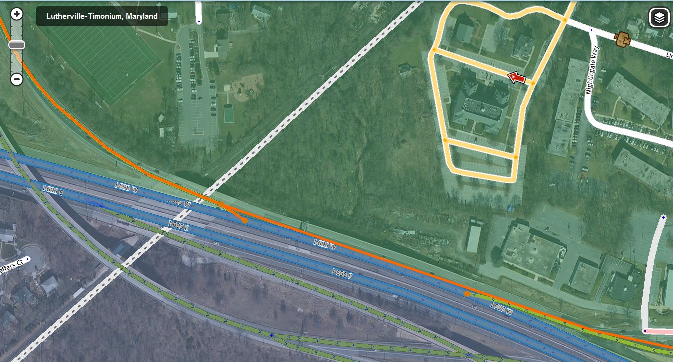
This ramp from N Charles Street needs to be connected just past the node at the beginning of this Exit 24 ramp, and not directly to I-695. The first ramps is signed “To I-83 N / York PA” and should not be connected to I-695 W.
This will solve the UR submitted today where Waze directed the driver to take the I-695 W ramp on the N Charles St bridge and then take Exit 24 from the Beltway.
No stated minimum, it just has to work. It should not be so short that a wandering GPS would skip it and cause a recalculation. So a segment that is a few car lengths is probably a bad idea.
Should this road connect to the ramp I just extended?
Sorry I’m a bit late to this, but I’m confused. This might be because the UR is no longer there. I don’t see how this prevents waze from routing over the I-695 W ramp on the N Charles St bridge and then take Exit 24 from the Beltway. Additionally, although the ramp is signed from northbound N Charles as “I-83 N / York PA,” I have always been under the impression that the ramp would provide access to I-695 W from Bellona Ave, Clark St and southbound N Charles. However, I have not driven the interchange recently. I did look at the the MD SHA here early on in the construction.
The original UR indicated that waze directed the driver to take that I-695 W exit however they chose to take the I-83 N exit. I inferred that they intended to go North on I-83.
Given the amount of traffic on the north side, it would be easier (and safer) for the driver to take the I-83 N exit from N Charles St rather than deal with other Beltway drivers merging into the driver’s lane attempting to take Exit 24. It also eases congestion (theoretically).
That SHA Image was helpful in reconstructing the segments & labeling ramps after someone unlocked the segments for me earlier in January.
I see what the fuss is all about here now. This is a tough one. Northbound drivers on Charles face that BGS instructing them to either take the curved ramp to get to 695 outerloop or the straight ramp for 83.
However, consider drivers heading southwest on Bellona Ave from York Road/Lutherville, or south from Charles/Nightingale Way. To get to the outerloop, as many often want to, they cannot access the curved ramp, so they go straight down the straight ramp to get on the outerloop.
There are no physical barriers preventing drivers on the straight ramp from merging with the outerloop. In fact, with the new lane configuration, they only need to get over one lane. On the outerloop at the end of the ramp the lane config is as follows:
Lanes 1-3 through traffic on the outerloop only
Lane 4 diverges allowing drivers to take 83 or stay on the outerloop
Lane 5 is exit to 83 only
Thus, I think the small ramp segment should be removed, reverted to the way it was before this post, no offense to anyone.
The BGS here is designed to encourage Charles Street traffic to utilize the ramps safely and efficiently. Similar is the BGS from the innerloop/83 saying traffic wishing to go south on Charles and then turn left at Kenilworth must turn right at the light at the end of the ramp.
I went to a presentation the SHA did for this project when it started. I remember the engineer saying they wanted to prevent people from weaving across southbound Charles street traffic to make that left, but there was just no feasible way to physically prevent them without negatively affecting the rest of the road, especially bicyclists.
Similarly, the topic of contention here is the best case scenario with the land and money SHA had to work with.
Chew on this: The original plan called for a grade separated ramp/bridge over drivers heading from the outerloop to 83, so that no dangerous merge would be necessary, but I guess they didn’t have the money for that. Would have been less confusing.
[youtube2][/youtube2]I made a short youtube video this afternoon demonstrating the intersection coming north on Charles Street, and then making the left down the ramp. I was heading onto the outerloop though, in protest to the signage. You can see that it was not particular harrowing, but may be able to see how it quickly gets clogged up. Definitely not an optimal situation. I appreciate everyone here working out a solution.
Okay, I’m late to the party here. And it may be my three cones talking, but I feel like the ideal solution might actually be to duplicate this segment: PermaLink.
Then, change the turn permissions for one segment to allow traffic from bellona to both 695/83 and the second copy to only allow traffic from charles to 83 only.
It may not exactly be kosher, but it would solve the problem.
In my opinion, the current problem lies with how Waze seems to prefer (by UR’s and Live Map) the to I-83 N / York PA Ramp over the Charles St “to I-695 W / Pikesville” Ramp when the destination is west of the I-83N interchange along the outer loop.
This follows the signage (BGS), is safer and SHA’s intent for the interchange. See this post earlier in this thread.
Any more seasoned editors know a way to give this ramp a higher priority without significantly penalizing those intending to drive on I-83N? I don’t think double segments would help here, nzahn1.
This is a tough one. We have four routing scenarios here:
Charles N to 695 W - should use loop ramp
Charles N to 83 N - should use left turn to Bellona ramp
Bellona & Charles S to 695 W - should use Bellona ramp
Bellona & Charles S to 83 N - should use Bellona ramp
I tested them and 1 is the only one that isn’t working for me. I agree with nzahn that we should provide another ramp segment, so we’re not relying on a road type penalty for correct directions. This would also allow us to use the correct names since signs on Charles N say “to I-83 N” while signs on Bellona say “to I-695 W to I-83”. I’ve seen it used in a similar situation here, and I’ll see if I can find the accompanying forum discussion.
This mockup has all the turn restrictions set as they would have to be set, and indications as to all the names that should be used on the ramps (not exact, but clear).
The extra node is to prevent the known “same-endpoints-multiple-segments” bug. The dual ramps are exaggerated for simplicity, but they should be drawn reasonably close together at the actual interchange.
Relying on road type penalties simply will not work. That short ramp should be ramp type (and one segment, not two).
There has been so much general resistance to dual road use that I’m somewhat surprised that the proposal is being met with approval here. We can certainly edit the ramps this way. But it should be monitored or locked very high, as everytime I’ve tried something like this (admittedly not very recently) someone comes along and changes it.
My only caveat is that taking the left turn ramp from N. Charles to I-695 W is not prohibited, so if its actually faster then I would want waze to route me that way. However, it is a difficult merge that the loop ramp is there to avoid, so given the URs I would agree to go with the dual ramp approach.