Hi Editors,
I’d appreciate your help with a map update.
We have a new development going on in Eagle Mountain, Utah. We have entered the two starting roads in Google Maps but it is saying the city is Cedar Valley, not Eagle Mountain. We are requesting the addition of these streets as they have been paved, with four houses already built. Listed below are the physical addresses:
2223 W WANDER LN, EAGLE MOUNTAIN, UT 84013
2217 W WANDER LN, EAGLE MOUNTAIN, UT 84013
3004 N WANDER LN, EAGLE MOUNTAIN, UT 84013
2988 N WANDER LN, EAGLE MOUNTAIN, UT 84013
Here is the parcel SN to view at https://maps.utahcounty.gov/ParcelMap/ParcelMap.html[b]Serial:[/b]59:052:0021[b]Owner:[/b]DAICLH LLC
Permalink: https://waze.com/en-US/editor?env=usa&lat=40.29259&lon=-112.07963&zoomLevel=16&segments=522783702
Reason:
Thank you in advance,
Thanks for reporting the problem! I see these new streets on Utah County and Utah State GIS, and can get them added to the map. And it does appear the little community of Cedar Valley has been annexed by Eagle Mountain, so I will get those switched over to Eagle Mountain as the primary city, including the western end of Pole Canyon Blvd (now Tiffany Ln according to other reports).
It will take 1-2 days for the new streets to appear on the map and a few days or perhaps a week for the addresses to be indexed. The city labels on the map… may or may not update automatically, hard to say. A manual process may have to happen for those boundaries to update; let us know if you continue to see Cedar Valley labeled on the map.
Thanks again, stay safe, and happy Wazing!
Update: I received a response from Google accepting my change to “Firefly Model 101”'s address, correcting the city to Eagle Mountain. I could not get the address to take with a West prefix though, but this should help. Other submitted changes are pending review.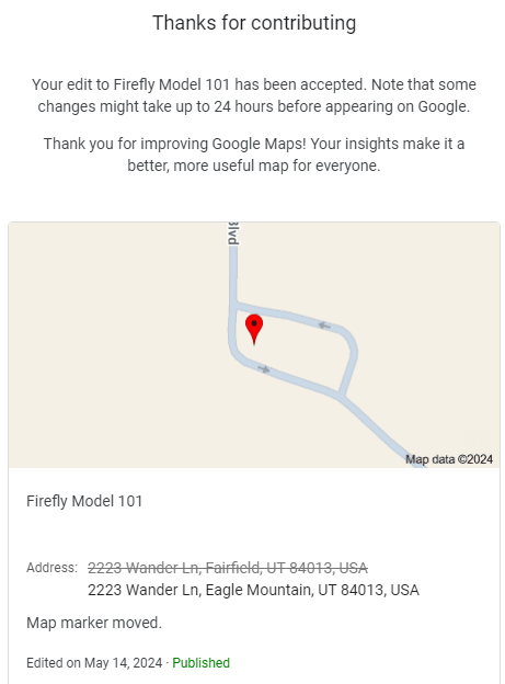
I have received emails from Google Maps accepting 2988 N and 3004 N Wander Ln.
You are amazing! Thanks again for your help. How long does it take for them to accept corrections for how the roads are drawn and named usually?
Thanks, and you’re welcome! Google Maps updates tend to end up in one of 3 categories for timing. Sometimes they’re instantly accepted by an algorithm and show up within 12-48 hours. Sometimes they take a day or two for somebody to look at them first, accept the change as submitted, and then it’s pretty quick.
The third category requires somebody to actually think about it, research, or manually change something. Bad luck in that case, as about 90% of the time in my experience, the edits get rejected or perhaps time-out and expire after about a month or more. That may be what’s going on with the geometry and naming changes I submitted. It may have been too much to get a rubber stamp approval, so it might take longer than your deadline and might be rejected anyway. It might have been more acceptable to make changes one small step at a time, but at this point I can’t do that while my overhaul is still pending.
The good news is the current set up with a one-way loop will direct (prospective) residents and visitors into the neighborhood the correct way, and they’ll know they can just go back out the same way and ignore Google if it tries going behind the homes. Eventually getting Google Maps fixed will be easier once they get updated imagery and more users driving through the area.
Hello @rocketsciguy,
My name is Zach and you helped me last year with this new development. Are you still edititng for Waze? I have some more requests if you’re available! Hope to hear from you soon!
Hello again @usa_csqa6ne5 !
Yes, I am still around and can help out, but my availability is somewhat low this week. But others can jump in if we need to. Where does the map need updating? Can you provide a Permalink from the Waze Map Editor or from Google Maps to the development? Hopefully the county has recorded and published the subdivision streets and addresses already (sometimes Utah County GIS is slow to be updated), as that will make it much easier to map.