I-95 Southern Approach to the Fort McHenry Tunnel Preservation Project
At this point I see no indication of when the ramp closures will occur.
I-95 Southern Approach to the Fort McHenry Tunnel Preservation Project
At this point I see no indication of when the ramp closures will occur.
Cedar Lane at MD-355, Bethesda, MD Closing:
From the SHA:
http://www.roads.maryland.gov/pages/release.aspx?newsId=1921
Based on this UR, is Keith Ave closed off 95 or 895?
I-83 was closed today at Guiford Ave SB and seems to be closed every Saturday (and Sunday?). Here’s a GIF of the VMS
https://plus.google.com/108912181557962474883/posts/Ny2pEUCMD4f
I reported in app but it’d be nice to get the turn restriction in Waze.
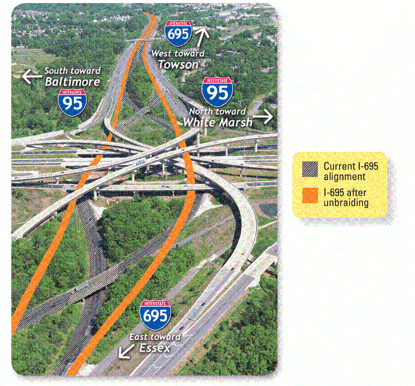
The Unbraiding of the northern interchange of I-695 at I-95
Phase III of the I-95 Improvements with the Express Toll Lanes Project includes the “unbrading” of the I-95 / I-695 Interchange. Construction begins this Summer, involves realigning that portion of the Beltway from US-1 to MD-7. Scheduled completion: Summer 2016.
Links to the Project page.
Permalink
On I-95 Northbound in Baltimore city, there is a lane closure so that 95 is effectively divided into two routes. The left lane, after Caton Ave, becomes an express with no exit before toll all the way through to the tunnel. The next lane is closed with jersey walls. There is no way to get into the rightmost tube from this lane, nor to any of the exits along the way (e.g. 395). This also means that there is no way to exit at Kieth Ave. Should there be any changes on WME?
I should say that there is no safe / easy way to get off at Keith Ave. You’d have to cross like 15 lanes to do it, with a killer blindspot.
I have had the pleasure of being able to avoid 95 through the area. The MDTA seems to have this to say about the lane closure. If permanent, I would map a through lane and local lanes like this separately to ensure that the keep right instruction is given at the split if necessary. The question becomes can we map the trough lane, have the change take effect before “mid-July,” and then get rid of the lane without expending too much effort or leaving any long term problems with the map. My initial reaction is that we can. Do you want to tackle it?
Maryland 832: Six Week Closure for construction in Westminster.
http://ccgovernment.carr.org/ccg/releases/Route%20832%20Closure%202014.pdf
"The temporary closure will start Monday,
July 14 after 9 a.m. "
"The 1.5-mile detour will direct traffic to turn right onto Tyrone Road, turn left onto MD 140,
then left onto Mayberry Road, and then turn right onto westbound MD 832. Portable electronic
message signs, cones and barrels will guide drivers around the work zone.
Crews will maintain driveway access for residents along westbound MD 832 while work is
underway. The six-week closure, near the 2700 block of Old Taneytown Road, will allow
SHA’s contractor to work between 6 a.m. and 9 p.m. "
“All work is scheduled for completion by August 22”
I am the AM in the area of the construction. Since the eastbound lane will still be open to traffic, I plan to make this a one-way road eastbound during the closure.
Waze has a new closure system that is sort of a mega event lite version for construction and emergency road closures. I have submitted this closure through this system. The advantage is that the closure should appear on the map.
Do you think that the westbound lanes will be closed all the way from Tyrone to Mayberry? In other words the way I read the release I’m betting that you will still be able to turn left from Baust Church to Old Tanneytown. Thus, will it be sufficient to simply mark the first segment to the west of Tyrone as closed westbound?
Thanks, Carl! Is it still necessary for me to do anything like disconnect segments?
No. Actually it is somewhat imperative that we do not disconnect segments. These closures are tracked by segment ID. So if there are junctions removed, added, disconnected or reconnected before the closure is reopened it will cause problems by changing the segment IDs. Waze is recommending that I lock the segments at a high level to prevent the segment IDs from changing before or during the closure. So don’t take it personally if I lock you out there for the duration of the closure.
Do post here if the road you find out the road is reopened before August 22.
I’m not entirely sure what they’re going to close. I imagine it would be closed only as far as Baust Church Road, as that is another state highway (MD-84). Indeed, Old Taneytown Rd crosses the Meadow Branch River between Tyrone Road and Baust Church. Since Baust Church Rd does not continue to 140, they will have to detour westbound traffic using Mayberry.
I will commute to work using Old Taneytown Road instead of Route 140 on Tuesday morning, to see exactly what they have closed (eastbound will be open, so I’ll be able to see what they have closed westbound). I usually leave for work around 7:30a, and the SHA press release says they won’t be closing the road until “after 9:00a,” so I won’t be able to catch this on Monday morning.
I drove in to work this morning using Old Taneytown Road (to verify something else).
There is a sign posted westbound just before Tyrone Road: “NOTICE – MD-832 westbound to be closed, on or about 7/14/14. Reopens 8/20/14.”
No posted detour yet, nor any other signs indicating what segments will be closed.
Should we follow the press release (August 22) or the posted sign (August 20) in determining a re-opening date?
Since the press release said by August 22 I put it in for the end of the day on August 21. Seems reasonable to change to August 20 based on the sign.
Verified this morning (by drive-by) that MD-832 W is only closed for a very short distance after Tyrone Road. (Just the culvert repair area is closed.)
Just spoke with the PIO at Baltimore DOT. 83 Northbound will be closed between Fayette (the beginning) and the Madison Street onramp. Drivers will be detoured via Fallsway to the Madison St onramp. Closure is 9PM friday to 5AM monday. Can we close it with a restriction on WME? Level 5 locked.
We are to use the form in this thread: Road Closures Form for All Editors. Closing through the form will show up in the app and Live Map as “closed.” While closing in WME will also prevent routing, it will not show up as “closed.”
Awesome, done!
Elliot,
I’m looking at the entry you submitted. The permalink is only for I-83 N as far as the Gay St on-ramp. Will there be access from Gay Street or only from Madison (that is will the Gay St ramp be closed as well)?