There is also a new place merge feature. A new PP created next to an existing PP (the new PP must have the same name and category) will create a PUR to merge into the existing PP.
Hi,I think there is a bug while changing places of Area type, the Save button is not updated according to changes (not get a red count number at all) and can not save the changes…
(I tried different changes - geometry, adding a street, the problem is always the same)
There was an issue with the closest segment script causing the save button to not update but another change would trigger a change. JustinS83 fixed it this morning. Make sure if you are running that script its the fixed version 1.0.3.0. May not be the issue but something similar so worth verifying.
So when we have a house number ánd a residential place, what is used?
2nd, can you please put the residential place navigation point at the same place as the corresponding house number? And the triangle at the place where the house number is?
Nothing really changed as far as HN and RPP, except that now the RPP stop point can be moved around. There is no conversion from HN to RPP or anything.
How would one use the new entry point for a PP or RPP? I’ve always placed the stop point of the PP/RPP in the correct location, so I don’t understand the purpose of this new feature. Can anyone give me an example?
Edit.
Ok, I basically wanted to +1 this Would be really useful!
Can you explain this feature? How is setting an entry point different from replacing the venue in previous versions of the WME? What does the position of the place itself represent?
When I first saw this, I thought there would be two positions associated with a place:
(1) the actual position (entry) of the place, and
(2) a navigation point.
The “finish bubble” could be shown at the actual position of the place and navigation could end at the navigation point. This way Wazers could easily find the place even if the recommended navigation point differs from the physical position of the place.
We did some experiments and the finish flag still dropped on the navigation point, totally ignoring the location of the place point. We would appreciate more guidance about the use of this feature please.
Previously, creating an RPP or PP, would trigger the search engine to look around for a matching address, street name, or closest segment.
Now you can modify the entry point to places, and thus force the search and routing engines to always navigate to that point for the specific venue.
This is very helpful in cases where a store might be located on a main street, but the actual entrance is out back.
Or if a house has a certain address, but the best stop point to get there is actually on a different street.
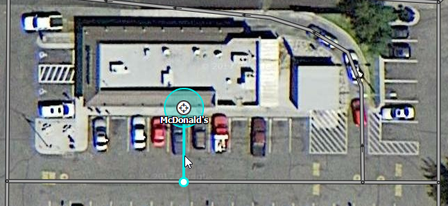
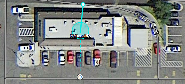
Some locations have the point place, if put directly on the building, closer to a “wrong” segment. For example, a fast food, where the building center is closer to the drive-through rather than the front entry. Until now, we have to nudge the point place closer to the desired stop point:
(non-dashed line connecting PP to nearest segment is a script, not a core WME feature)
Now, we can keep the point place right where it should be, but adjust the stop point, very similar to what we do with Area Places:
I’m not saying map all the drive-throughs, but this is only an example. You can find lots of similar situations without looking too far or hard.

 Would be really useful!