I think there are a couple of problems with this intersection, but I’d like to bounce them off someone with more experience on complex intersections.
Problem 1: When navigating north-east from Station Rd to Seven Hills Rd, the on-screen and spoken navigation instructions given are “turn right onto Prospect Highway then keep left to Seven Hills Rd”. However, for someone sitting at this intersection, Prospect Highway is only to the left, not the right. The right turn is signposted as Seven Hills Rd - although of the two right-turn lanes, only the left-most is permitted to branch to Seven Hills Rd.
Proposed solution:
Remove the street name from segment 100317286 to prevent the mention of Prospect Highway. (This shouldn’t affect the instructions for any other navigation/)
Remove the name from the next segment 90702204 as well, provided this still gives a clear “keep left onto Seven Hills Rd” instruction to those travelling from Prospect Hwy.
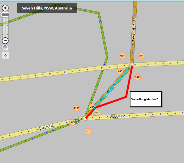
Problem 2 is travelling in the reverse direction. The instructions given are “keep left onto Station Rd” which is ambiguous for those unfamiliar with the area because, from Seven Hills Rd, you can turn left into Abbott Rd and you can’t actually see Station Rd yet. The better instruction would be “turn right onto Abbott Rd then turn left into Station Rd”.
Proposed solution:
Change the geometry at the A end of segment 90718867 so that it starts off straighter, then turns to the right
I’m not sure if the geometry at the B end needs to be kept roughly as it is to ensure a “turn left” instruction?
Something like this?
For removal of doubt, the U-turn segment 90718900 looks to be correct to me and shouldn’t be removed.
That’s a good question. There are only two B roads in the entire Sydney region - B59 heading northwest from Windsor, and B83 heading north from Hornsby (old Pacific Highway) - 40+ and 20+ km (straight line, not by road) from the CBD. (refer http://www.rms.nsw.gov.au/projects/key-build-program/alpha-numeric/index.html)
There’s two broader questions here:
What are our criteria for unsplitting a road that has been set up as split, but doesn’t really meet the criteria for being split? The wiki says
how much imperfection is enough to justify it?
Given the small number of B roads in Sydney, is “B road” the right criterion for a Minor Highway, or should it be something else? If it is not a minor highway, do we still want to lock significant arterial roads in Sydney that aren’t A roads at L3 to reduce the risk of damage?
Having not been through the effort of unsplitting a road - or the effort of cleaning up a major road damaged by an inexperienced editor - I’d defer to the L3+ editors on these questions.
Problem 1:
Your solutions are ok and will fix the issues you have with the TTS prompts
Problem 2:
The problem is more to do with Seven Hills Rd and the turning lane connection to Abbott Rd here.
This is where you are getting the keep left prompt and not from this section of Seven Hills Rd, because the turning lane is unnamed and the angle it connects to at Station Rd.
Another issue you have, is that the u-turn and Seven Hills Rd both connect at the same point.
Looking at street view, unless the lights are phased differently for the u-turn, it looks like you cannot turn left onto Station St and the current configuration allows this in the map.
Just above the section you quoted had the following in bold
Currently the road has been divided and is working. There is a median stip that runs for most of the length of the road. If you are trying to get to a particular business you can be routed the wrong way when the road hasn’t been divided.
To get to the other side of the road may involve u-turns, which in most places is illegal, or some long round about way like round the block. In busy areas that can take considerable time trying to make a turn or waiting at traffic lights.
In this particular case, this road, you can be routed to the correct side of the road to get to a particular business in the area.
Everything we do, when we edit the map, is a compromise between simplicity and ease of use for the driver.
Your example to TimAThing about the gap in GPS tracks did not state the zoom level. The image you posted was at the 10m/20ft zoom level and he may have got the impression that this is the zoom level required.
I have said you can get the same result when there is a visible gap.
The Wiki is an ever changing entity and is in a constant state of change. Most country specific Wiki’s use the main Wiki page details and add or modify things to suit that country.
The Austraian Wiki section Style Guide for Map Editing has a link which points to the Best map editing practice Wiki page which is the link I provided about divided roads.
I was finding it helpful seeing the discussion - helps to see different perspectives on issues and how different people weigh up the grey areas. In any case, once you’ve discussed please post back here so we have a conclusion.
If the best thing is to unsplit the road, I’m willing to give it a try if someone can review or supervise (I’ve only unsplit a very minor road before).
I think most of us agreed that for historical reasons that there is way to much unnecessary dual carriage in Australia.
In my opinion the question became do we do anything about it?
That wasn’t really answered but the rule of thumb is “If a road is working don’t touch it”
My thoughts are if you drive that section of road you can take charge of it. If your keen I can help you single carriage. Then you can judge for yourself. (not keen if you don’t drive it).
That logic makes sense. The problem that I had noticed only affected a small section, not the entirety of Prospect Highway and Abbott Rd, which would suggest a tweak of names and geometry is preferred over a full unsplit.
(I do drive that road - Abbott Rd more than once per week, Prospect Hwy around once per fortnight but it’s close enough that I can divert myself along it when needed.)
What about the other questions, of whether all non-B roads in Sydney should cease to be Minor Highways and whether they should be permanently lowered in lock level? Is there an answer, or should I create a separate thread for this discussion? It’s not clear to me how to reconcile the “B road only” ruling with this text from https://wiki.waze.com/wiki/Road_names/Australia#Minor_Highway:
I think Glomp and myself both agreed that they should be “Primary Street” therefore lock level 1
In summary we only have a few road types so we had to draw a line in the sand somewhere. My guess is that Sydney “B” roads are of a higher standard than the Hwy we are talking about?
For this specific road, I think Primary Street/Level 1 is appropriate. For major arterial roads such as Epping Rd, I’m not so sure but it all starts getting subjective there.
Has someone taken on the task of converting the shouldn’t-be-minor-highways in Sydney to Primary Streets? Or should we just request permanent unlocks and make edits as needed for other ones?
There are no B routes in Sydney (except on the outskirts). I personally think some of these major arterial roads (eg. Epping Road) should be classified as minor highways (despite the lack of route number) for routing purposes, but I understand the wiki rules say otherwise. If we changed them all, Sydney would be one of the only waze cities to only use Freeways and Major Highways (no Minor Highways). I think further discussion is probably needed on this topic.
I believe that possibly, with some exceptions, any road that is not a freeway type road, that roads in red are a Waze Major Highway and all green roads and probably most blue roads would be a Waze Minor Highway. Since i’m not a sydneysider, I don’t have much knowledge on how the road network operates so from that point of view, I’m limited in how I can help out.
In Victoria, especially in the metropolitan area, we use a system which is based whether the roads are controlled by the government (VicRoads) or the local councils, and from my experience it works efficiently.