I have a good few ‘hints, tips & suggestions’ PMs still sitting undelivered in my outbox.
We’ll have to see what new functionality WME provides wrt communicating directly with other editors.
Hopefully this will be released soon.
I have a good few ‘hints, tips & suggestions’ PMs still sitting undelivered in my outbox.
We’ll have to see what new functionality WME provides wrt communicating directly with other editors.
Hopefully this will be released soon.
It is quite surprising how “un-social” Waze’s “Social” editing system is!
I’ve got a bit of a question, after reading the wiki. The following is currently there:
There also seems to be a split between the Rxx and Rxxx routes, in the wording. However, my question is about the following scenario:
Consider the R57 and the R714. Both are a single lane in each direction, both have a wide shoulder, and a 120km/h speed limit. The only stops on the R714 between the N3 near Warden and where it meets the R26 near Bethlehem are the one-way stop street on the T-junction with the R26 and the 4-way stop where it crosses the R57.
Now, the R714 meets the definition of a Minor Highway perfectly, as does the R57. They also both seem to meet the Major Highway definition, with the exception of multiple lanes. The road surface in both cases are almost identical (barring potholes due to lack of maintenance). Therefore the only criteria that differentiates them is the route number (Rxx vs Rxxx). I was wondering, if instead of focusing on the Rxx vs Rxxx naming to determine the type, we should rather focus on the road condition as well.
I am not too sure what criteria the government used to number the roads initially, but to me the above differences feel a little arbitrary. It’s probably been hashed out between the older Waze users before, but I can’t find much on the forum to explain the difference between the two types, so if someone would be kind enough to explain the reasoning here, I’d much appreciate it.
I’m in the process (when I’m not distracted) of trying to get some better content written to replace what is currently on the wiki, but here are my thoughts briefly about the case you describe.
First of all, I would say that since the roads you describe are R roads, this means they should be /at least/ minor highway. Presumably they are not freeways (since again this is fairly unambiguous; I’m pretty sure all of our freeways are demarcated with freeway starts/freeway ends signs), so this leaves the question of whether they should be major highways, or just regular minor highways.
Now, if we are following the lead of the existing standards, there are two choices. The US guys determine Major vs. Minor based on the road type. A Major Highway should have a speed limit at or near to interstate speeds (that would probably translate to 100-120km/h in our case), multiple lanes of travel in each direction, few traffic lights with dedicated turning lanes or ramps at any crossings, etc. Under these guidelines, the R57 and R714 should both be Minor Highway since they only have a single lane of traffic in each direction.
On the other hand, the UK guys took the position that since there is practically no difference in the way that Waze treats Major and Minor Highways, the distinction should be made solely on the basis of the government road designations. So their M roads (Motorways) are Freeways, trunk-class A roads (which are basically their Ax roads) are Major Highways, and non-trunk-class A roads (basically Axx roads) and B roads are Minor Highways. This maps to our road system in roughly the following way: Freeways are N roads and M roads that are actual freeways, Major Highways are N roads that are not freeways, and Minor Highways are R roads. Under these guidelines… the R57 and R714 should also both be Minor Highway.
So I guess in this case it’s fairly clear, but obviously in other cases the US and UK systems will disagree so we need to make a decision. I’m leaning towards the UK system again, just on the basis that it makes it a lot easier to decide which road type to use (you don’t need to know anything about the actual speed limits etc. along the road).
Thanks, that makes sense.
I agree that we should make all R roads minor highways, unless they actually deserve to be upgraded to major highways, or get another designation (perhaps primary street in a city).
Downgrading a minor highway to primary street in a city mostly defeats the point of making it minor highway. The thing that differentiates a minor highway from a primary street is the scope of the areas it connects, not necessarily how amazing the actual road is. As the wiki page on USA road types says:
If we go purely by existing road quality, long-term roadworks and current surface states, we are totally screwed. We would have a large number of secondary routes classed at 4x4/Dirt, and I’m referring to the ones with gravel surfaces ![]()
We likely need to look at the ‘Official’ classification or intent of the roads.
So, just another spanner in the works here, as if there is not enough of them already hampering the ‘hard & fast’ rules.
As far as Freeways are concerned, I think we can all agree on the ‘ramp access only’. They should be easy to spot. In addition to this, roads typed as freeway will in all cases have their start and end indicated by these signs :
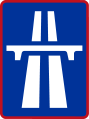


Freeways predominantly makes use of signage on a blue background, similar to this :
The main question is, is large expanse separation required, or would the white line barrier in most places on the N-Routes be enough to disqualify the Freeway classification? Road speeds and access remains on par on most of these sections, as is quite visible on the Jhb <-> Durban ‘N3 raceway’, especially the long ruler lines through the Free State.
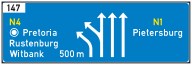
Major and minor routes makes use of signage on a green background:
Where they are NOT typed as freeway, we are likely ignoring some of the ‘shielding’ that is currently part of the road network, similar to the US shielding.These are typically indicators of the ‘National’ or N routes, major R routes and minor R routes.
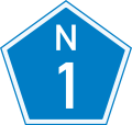
The N Routes likely needs to be classed as minimum Major Highway where it does not comply 100% with Freeway. Majority are multi-lane and signage and maps includes the pentagon shields, but this mostly on printed & web-based maps though (Pssst, Waze Devs, when the US shields are sorted…):
I cannot verify that I have seen recent samples on actual roads, so a permalink would be useful if it still exists and is maintained. Has anyone spotted some recently ? I have not done long-haul trips in the last 2 years, and pre-Waze did not really care. I’d need to hunt for any now.
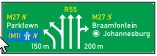
Major Secondary roads use the diamond shaped route markers.

These I have seen on the R24 heading through Jhb, but there it rarely would qualify as major anything due to the intersections. The major ones ares supposed to link up provinces.
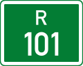
Minor roads like secondary R and some S & D routes uses rectangular shields:
As these are supposedly official indicators, do we use these as broadly based categories supporting some of the rules ?
Freeways should be no-brainers in & around cities and larger towns.
N=Freeway & Major based on signage & ramps. Possibly reduce to Major where there are no large separating Median or concrete barrier. The M1 is a Freeway, just with a concrete barrier.
Rnn=Major Highway where multi-laned, except long intersectioned stretches, where its reduced to minor highway
Rnnn=Single-laned, - Minor highway, possibly reduced to primary streets in Towns.
Primary Street / Street /private - Also no-brainers in 99% cases. Only issue might be the common occurrence of the ‘M’ routes, like Sandton where every second street is part of an ‘M’ route, and typed as Primary Street.
Gravel / 4x4 - Only streets, not extreme 4x4 trails.
Skip all non-drivable, maybe keep rail - People still insist on paving the Gautrain track every 2 days. I’m almost tempted to make it Major Highway so it shows up clearly in the client.
Does this waffling make sense ?
Just as a matter of interest, the routes.co.za website is a very detailed (and Copyrighted) reference covering the N, R and M routes.
Long Haul routing on the N1 ( Pretoria to Cape Town) did make use of Primary streets when I tested a while ago It might fail if the defined Primary streets exceeds specific distances on the interspersed stretches of the higher road types.
So I’ve come around to the idea of setting the Waze road type based purely on the official classification, for the simple reason that this vastly reduces the number of judgement calls that an editor has to make, and potentially clash with another editor over. It also makes the map look closer to what a normal streetmap would look like, which appeals to me for aesthetic reasons ![]()
In this light, the classification would look something like this:
Freeway:
Only roads officially classified as freeway (marked by R401 or R402 signs at start / onramps and (R)401-600 / (R)402-600 at end / offramps). These are the signs identified in Kuhlkatz’s post above mine. For the record, I have seen the “shield” style blue signs recently; I think it may have been along the M1 in the south of Johannesburg but unfortunately I don’t remember where exactly… aha, found it in my IRC logs. Unfortunately the image quality is poor, but you can see the pentagon R29 N shield as well as the rectangular signs for M1 N and M27 N.
For single-carriageway freeways with no dividing median or a very narrow one, the road should not be split into separate carriageway segments, due to how close the GPS tracks are. The existing guidance on the wiki suggests that all freeways should be split, but this is written with the US interstate system in mind which has no single-carriageway freeways of this nature.
Usually freeways will be designated N routes, M routes, or R routes (anyone know of any exceptions?) and should be labelled by their route designation rather than road name, as the signage will identify the freeway by route designation.
Major highway:
N routes which are not freeways, and all R## routes.
Minor highway:
All R### routes, and S routes / M routes which are significant connecting routes.
Primary street:
S routes / M routes which are not significant connecting routes, and any other locally important route within an area.
I’m not 100% sure I’ve sorted S routes correctly above, since I have almost no familiarity with them (I’ve never actually seen one myself while driving).
I was looking for some of these on the non-freeway major & minor routes using the green coloring scheme and couldn’t find any. It seems they disappeared overnight, or it’s just because I was looking for them.
There are S and D routes, which mostly seem to be non-paved. They typically serve as access to farms for farming communities. With the current classification they will likely be typed as “Dirt/4x4 trails” anyway. If Waze does support a separate surface option in future ( paved / non-paved etc.) I doubt that they would be classed above primary, or even street for that matter.
They do act as access roads to other primary and secondary routes for these communities.
You posted a link to a green one for the R24. I think I’m confused about what you mean? ![]() Did you mean a blue pentagon for a non-freeway section of an N route?
Did you mean a blue pentagon for a non-freeway section of an N route?
I was trying to find one in an area where it matters, like on an open stretch of road nowhere near intersections where it can actually be classed as a major route. That part is in the middle of JHB with a traffic light at every intersection and pedestrian crossing, so nowhere close to a ‘major’ in terms of category.
I also could not confirm any rectangular shield visuals on the minors, except for the “S” one listed, which I know offhand from visiting friends in the area.
Sorry to dig up an old post but I feel we need to relook at this…
It would appear that our naming convention doesn’t gel too well with routing server - often giving much longer routes than expected.
See what I mean below:

With a change of type through towns (and a few tile updates) what you get is this:

I asked the Aussies what works their side HERE and the above seems to apply.
Essentially all that I changed was the road type through town. For instance if a major highway came in and exited town all the sections between would have been changed to major instead of being set to primary.
Your thoughts on this would be appreciated.
Hello
Im not sure i’m the most qualified to comment on this, but i agree with changing it to a major highway through the town. Waze should pick up that everyone drives slower through the town anyway if you care about the ETA and routing would be better.
I drove from PTA to Dullstroom this week and the directions it gave me to drive back was completely wrong and i checked the whole stretch of road, there was no errors on the road it just went through two towns.