[Script] WME Naming Auditor — France & Italie

:warning: France and Italy. This script applies the naming rules of the country you are looking at — French rules on a French map, Italian rules on an Italian map (in-town / centro abitato, INSEE / ISTAT municipal boundaries). The interface and the built-in help exist in French and Italian, and the language follows your WME profile, not the map: an Italian editor helping in France reads the French rules in Italian. :warning: The Italian port is in TESTING — feedback welcome.

WME Naming Auditor — v2.50.12

GreasyFork · GitHub

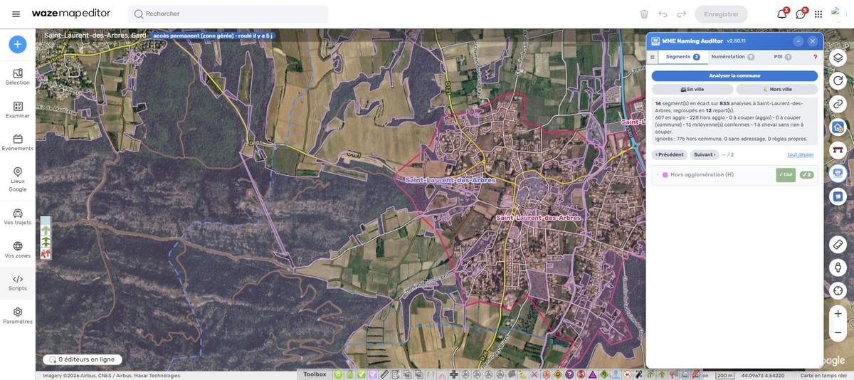
WME Naming Auditor audite le nommage et l’adressage des voies d’une commune entière, selon la règle agglomération / hors agglomération — le centro abitato en Italie —, à partir des contours communaux INSEE ou ISTAT.

Il ne remplace pas l’éditeur : il lit, compare à la règle, et liste les écarts. Rien n’est enregistré.

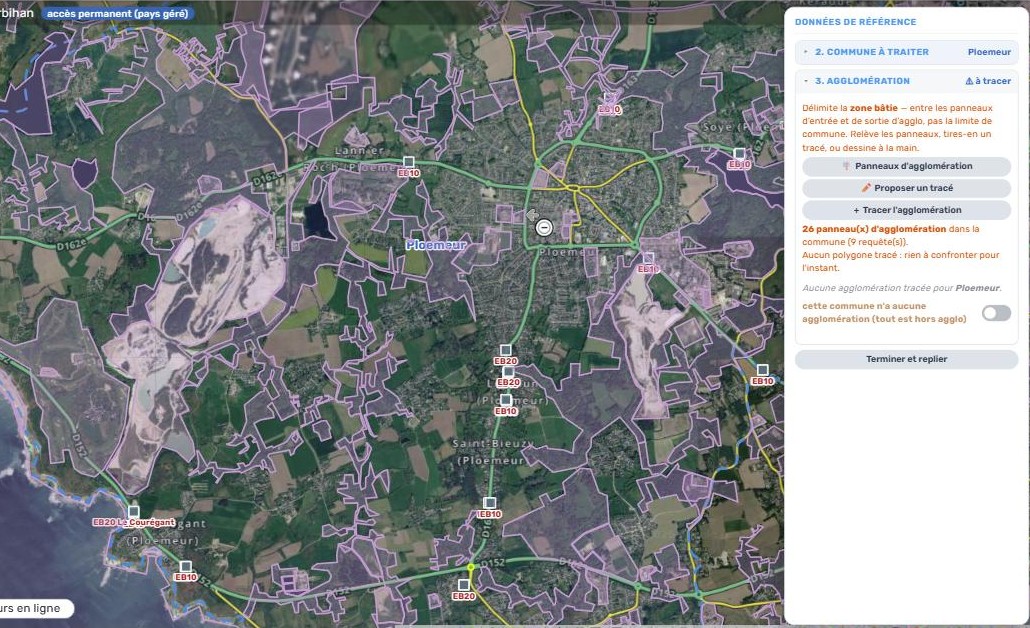
:clapper: Voir en vidéo : la zone bâtie, et les villages rattachés — une minute, sur l’exemple de Gruissan. C’est le point sur lequel on se trompe le plus souvent : le polygone à tracer n’est pas la limite de la commune, et une commune peut en compter plusieurs.

:triangular_flag_on_post: Le principe

La règle bascule à l’entrée d’agglomération (panneau EB10) :

  • en agglomération — la ville est renseignée, le nom de rue est le nom principal, le numéro de route passe en alternatif ;
  • hors agglomération — le nom principal ne porte pas de ville, le numéro de route devient le nom principal, et le nom de rue passe en alternatif avec la ville.

Le script ne voit pas les panneaux. Il déduit la zone de deux géométries : le contour communal, qui délimite l’analyse et fournit le nom de commune, et un polygone d’agglomération que vous tracez une fois par commune.

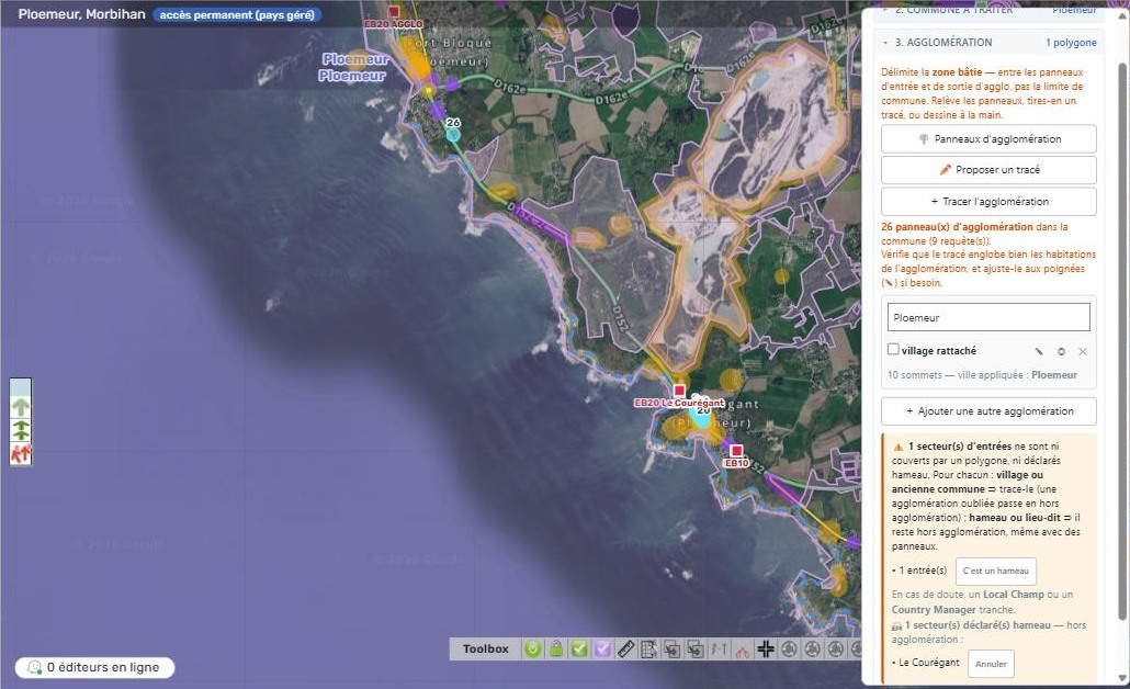
Les panneaux EB10/EB20 servent de point de départ, mais ils ne suffisent pas à faire une agglomération : un hameau ou un lieu-dit reste hors agglomération, même panneauté (règle votée par la communauté française, page Nommage des segments). Pour chaque secteur de panneaux, le script demande donc de trancher — tracer le village ou l’ancienne commune, ou « C’est un hameau » — et s’en souvient. En cas de doute, un Local Champ ou un Country Manager tranche.
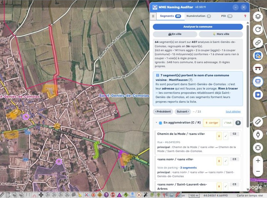
Un segment à cheval sur la limite (entre 20 et 80 % dedans par défaut ; un seuil pour l’agglomération, un pour la commune, réglables de 70 à 95 %) n’est pas corrigé : il est signalé à couper, puisque le bon nommage dépend de l’endroit de la coupure. Sauf les chemins de terre, sentiers, escaliers, voies privées et parkings sur la limite d’agglomération : ils ne portent pas de panneau d’entrée : ils ne sont jamais à couper, et leur ville est laissée à ton appréciation (le script ne propose ni de l’ajouter ni de la retirer).

:mag: Ce qu’il contrôle

  • le nommage agglo / hors agglo : ville, nom principal, alternatifs ;
  • les cartouches des numéros de route ;
  • les bretelles, autoroutes, voies ferrées, pistes, ferries, rocades, giratoires — chacun avec sa règle propre ;
  • la rédaction : abréviations, contractions, majuscule initiale, et confrontation au dictionnaire communautaire de WME Check Road Name ;
  • la numérotation : numéros de rue hors agglomération, POI résidentiels, doublons ;
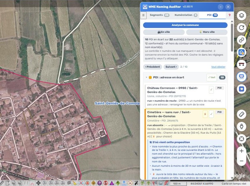
  • l’adresse des vrais lieux (POI) : rue, commune, numéro. Les aires, échangeurs et péages relèvent d’une règle propre — leur adresse est le nom de l’autoroute, sans ville.

Chaque contrôle s’active ou se coupe séparément.
:white_check_mark: Ce qu’il ne fait jamais

  • Il n’enregistre rien. Une correction proposée est déposée dans WME comme une saisie manuelle : elle se relit, elle s’annule (Ctrl+Z), et c’est vous qui enregistrez.
  • Il n’invente aucun nom : il réorganise ce qui est déjà saisi. Seule la ville vient d’ailleurs — du contour communal.
  • Il ne crée pas la norme : quand une règle n’est pas tranchée, il compte le cas sans proposer de correction. C’est ce qu’il fait pour les numéros de rue posés sur une voie nommée « Dxxx ».

:warning: La correction en un clic est réservée aux L5, L6, les Champs et le Staff — ce sont les seuls à pouvoir modifier partout. Le repérage, lui, fonctionne pour tout le monde : chacun voit les écarts de sa zone et les corrige à la main.

:bulb: Il explique ses propositions

Sur un POI, le script dit d’où vient l’adresse qu’il propose : quelle voie, à quelle distance, et sur quel critère. Une proposition qu’on ne peut pas vérifier ne se corrige pas de confiance.
:rocket: Mise en route

  1. Installer depuis GreasyFork.
  2. Dans WME, ouvrir l’onglet :label: du panneau latéral, puis Afficher la fenêtre.
  3. Cocher un département et Télécharger et charger : les contours arrivent
    en un clic.
  4. Choisir une commune, tracer son agglomération, analyser.

Le tracé de l’agglomération se fait une fois par commune et se conserve.

:speech_balloon: Retours

Les remarques et les défauts sont les bienvenus — plusieurs correctifs récents viennent de retours d’éditeurs sur leur propre zone. Ici, ou en issue GitHub.

Sources des données : contours communaux Admin Express (IGN) + COG (INSEE), Licence Ouverte. Rien de ce que vous éditez ne quitte le navigateur.


:it: In italiano

WME Naming Auditor verifica la denominazione e l’indirizzamento delle strade di un intero comune, secondo le regole del paese guardato, a partire dai confini comunali ufficiali.

In Italia applica le regole della Wazeopedia italiana :

  • dentro / fuori il centro abitato — il nome principale porta la città dentro, il numero di strada fuori ;
  • scudetti SS / SR / SP ;
  • frazioni nel formato nomefrazione, nomecomune ;
  • abbreviazioni vietate (V.le, C.so, P.zza), lettere puntate, sigle attaccate (SS12), date in numeri romani ;
  • obbligo di accensione dei fari fuori dal centro abitato ;
  • rotatorie : né nome né numero civico ;
  • formato delle rampe (> Verona, Uscita 17: Jesi Centro).

I confini vengono da openpolis / ISTAT — 110 province, caricamento automatico senza chiamate di rete.

:warning: Le regole seguono la mappa, la lingua segue il tuo profilo WME. Sono due cose indipendenti : un editor italiano che aiuta in Francia legge le regole francesi in italiano ; un editor francese che aiuta in Italia legge le regole italiane in francese. Anche la guida integrata cambia contenuto secondo il paese : non descrive mai un pulsante assente dal tuo schermo.

Lo script non modifica né salva mai nulla da solo : ogni correzione viene depositata in WME come se l’avessi fatta a mano — sei tu a rileggere e a salvare.

:warning: Il supporto italiano è in fase di TEST. I riscontri sono benvenuti : scrivete qui, o al Country Coordinator italiano.

GreasyFork · GitHub

:label: WME Naming Auditor — v2.39.00 — GreasyFork :link: — GitHub :link:


A one-minute video finally explains municipality zoning — the flagship feature of this version. It is linked from the script’s help section and from the first post in this thread.

Three editors in a row asked the same question: should my polygon follow the city limit? It wasn’t due to distraction — the script draws one outline on its own, then asks for a second one, and the interface said “Draw the outline of ‹municipality›” while the municipality boundary was actually displayed right next to it in blue dashes.

The drawing banner, the step-by-step guidance, and the button tooltip now say “Surround the built-up area of ‹municipality› — between the urban area entry and exit signs, not the city limit”. The video shows the case of Gruissan, which has three built-up areas, including two attached villages.

Also in this version:

  • Ramps: a name format check. The three existing checks prohibited specific errors — a direction that is a road, two stuck-together numbers, a poorly spaced colon. None required the format, so a ramp named “Av. de la Gare” didn’t trigger anything. The new check expects A6a: Paris, Sortie 18: Valensole, or > Orsay when no number applies. It highlights without suggesting — the number and destination are on the sign, which the script cannot see — and it is unchecked by default.
  • An incorrect figure in the help section, replaced by a measurement. It used to say “measured across five municipalities, two have no signs”. Measurement redone on two entire departments, with a sample of one in eight municipalities: 98% of the municipalities in Ille-et-Vilaine have at least one recorded urban area sign (41 out of 42), compared to 28% in Hérault (12 out of 43) — even though both departments are served by the same source. The discrepancy occurs at the department level, not the municipality level: where the source is provided, “Suggest a path” is the shortest route; elsewhere, manual drawing remains the norm.

:it: v2.48.01 — Italy, and the script in Italian

WNA now applies the rules of the country being viewed: French rules on a French map, Italian rules on an Italian map. Port requested by Silvio, IT Country Coordinator.

What Italy brings: openpolis / ISTAT boundaries (110 provinces, automatic loading without network calls), the centro abitato (built-up area) and its flowchart, the scudetti (road shields) for SS / SR / SP, frazioni (hamlets) in the format nomefrazione, nomecomune, forbidden abbreviations (V.le, C.so, P.zza), dotted letters, joined acronyms (SS12), dates in Roman numerals, the obbligo di accensione dei fari (mandatory headlight use) outside the centro abitato, and the ramp format.

The interface AND the built-in help are translated. The two axes are independent: the rules follow the map, the language follows your WME profile. An Italian editor helping in France will therefore read French rules in Italian. The help content itself changes depending on the country — it never describes a button that is missing from your screen.

A fixed bug that affected an entire province: the boundary source names 124 comuni (municipalities) in both languages (Bolzano/Bozen) where WME only lists one. Since the boundary name is the city that the script suggests, the 116 comuni of South Tyrol were flagged as discrepancies, and the fix suggested a city that does not exist in WME.

On the French side, three fixes from the same project: the panel had two “1.” sections (renumbered 1-2-3), four grammar errors in the help text, and the “Why only France” section still stated that the script closes outside of France.

:warning: The Italian port is in the testing phase. Feedback is welcome.

:it: In Italian

v2.48.01 — Italy, and the script in Italian.

WNA now applies the rules of the country being viewed: French rules on a French map, Italian rules on an Italian map. Port requested by Silvio, IT Country Coordinator.

What Italy brings: openpolis / ISTAT boundaries (110 provinces, automatic loading without network calls), the centro abitato and its flowchart, the SS / SR / SP scudetti, frazioni in the format nomefrazione, nomecomune, forbidden abbreviations (V.le, C.so, P.zza), dotted letters, joined acronyms (SS12), dates in Roman numerals, the obbligo di accensione dei fari outside the centro abitato, and the ramp format.

The interface AND the built-in help are translated. The two axes are independent: the rules follow the map, the language follows your WME profile. An Italian editor helping in France will therefore read French rules in Italian. The help content itself changes depending on the country: it never describes a button that is missing from your screen.

A fixed bug that affected an entire province: the boundary source names 124 comuni in both languages (Bolzano/Bozen) while WME only lists one. Since the boundary name is the city that the script suggests, the 116 comuni of South Tyrol ended up with discrepancies, and the fix suggested a city that does not exist in WME.

:warning: Italian support is in the TEST phase. Feedback is welcome: write here, or to the Italian Country Coordinator.

GreasyFork · GitHub

@asterix06

:label: v2.49.04 — the hamlet rule

The wiki page Naming of segments now states what the Country Managers have voted: EB10/EB20 signs are not enough to create a built-up area. A hamlet or a locality remains outside the built-up area, even if signed.

WNA aligns with this:

  • For each sign sector, a “It’s a hamlet” button — in the pre-tracing window and at the end of zoning — declares it: no polygon, and the guide no longer requests it. “Cancel” puts it back to be decided.
  • In case of doubt, it is a Local Champ or a Country Manager who decides, as the wiki says (and no longer the SM or RM).
  • Declared hamlets travel in the share export; the import only adds them to missing municipalities.
  • :it: The entire tracing area is translated into Italian, including texts containing a number or a name.

GreasyFork · GitHub

:label: v2.50.07 — des corrections plus sûres, et une nouvelle apparence

Le script est passé par un audit complet. Ce qui change pour vous :

  • Une correction ne peut plus écrire à moitié. Tout est vérifié avant la première écriture : si une commune visée n’existe pas dans Waze, rien n’est écrit — le script ne crée jamais de commune.
  • Un nom composite « D980 - Route de Bagnols » est séparé en numéro et en nom, sans perdre le numéro. Un tronçon de type Autoroute est traité comme tel, même nommé « N165 ».
  • Le :high_voltage: d’un groupe laisse de côté les écarts qui portent un doute, et le dit : ils se corrigent un par un.
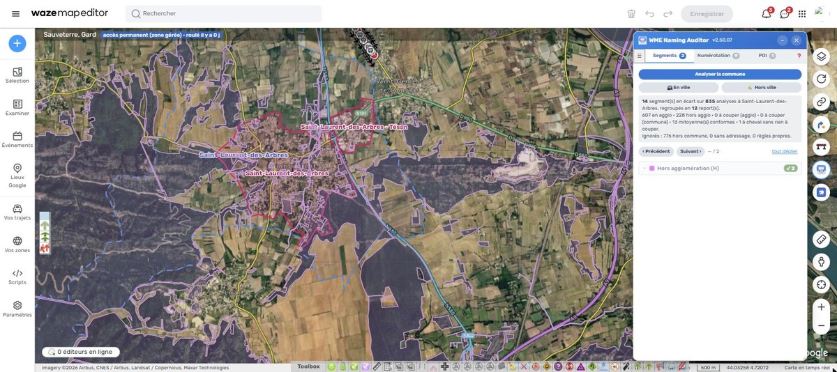
  • Supprimer un polygone affiche « Annuler » quelques secondes avant d’enregistrer.
  • L’import d’un fichier de partage respecte vos choix : une commune vidée, ou décochée « sans agglo », n’est plus réécrite.
  • Nouvelle apparence, commune à mes autres scripts : icône, boutons, interrupteurs, onglet Scripts avec explications repliables. La fenêtre reste dans la carte quand on la déplace ou l’agrandit.
  • La pastille de mise à jour installe la nouvelle version d’un clic.
  • :it: L’interface italienne est complétée (onglet Scripts, boîtes de dialogue, bilans), et le script dit « ISTAT » en Italie.

Rappel : la correction en un clic reste réservée aux L5, L6, Champs et Staff ; le repérage des écarts marche pour tout le monde.

GreasyFork · GitHub

:hammer_and_wrench: v2.50.08 — le cartouche hors agglomération, et la liste des communes

Deux corrections, remontées par des éditeurs :

  • Plus de proposition de cartouche sur un nom de rue hors agglomération. Quand tous les segments d’une rue portaient le même numéro de départementale en alternatif, WNA proposait de poser ce cartouche sur le nom de rue (exemple : « Route de Bussy » à Alise-Sainte-Reine). Hors agglomération, la règle met le numéro de la départementale en principal, sans ville, et la rue en alternatif, sans cartouche sur la rue : c’est ce que WNA propose désormais. Merci à onryou et à Glenan56.
  • Ouvrir la fenêtre charge les contours du département visible. Ouverte sans bouger la carte, elle laissait la liste des communes vide.

La mise à jour arrive toute seule par GreasyFork.

:hammer_and_wrench: v2.50.09 — no splitting at the sign where there is no sign

A fix, reported by onryou:

  • No more suggestions to « split at the built-up area entry sign » on dirt roads, paths, footpaths, stairs, private roads, and parking lots. These roads do

v2.50.10

  • Chemins de terre, sentiers, escaliers, voies privées et parkings à cheval sur le polygone d’agglo : le script ne propose plus d’y ajouter ou d’y retirer la ville, c’est à toi de voir (merci onryou).
  • :italy: Toute l’interface est maintenant traduite en italien : reports, bilans, barres de progression, contours, corrections…
  • Une vingtaine de fautes d’accent corrigées.

Mise à jour automatique par GreasyFork, ou Tampermonkey › Rechercher des mises à jour.

v2.50.11

  • Deux seuils de rattachement au lieu d’un, dans Réglages › Analyse : un pour l’entrée d’agglo, un pour la limite communale. 80 % par défaut, réglables de 70 à 95 %, avec un bouton « Seuils par défaut ». Un réglage à 100 % faisait signaler « à couper » un segment qui dépassait d’un mètre : il est ramené à 95 % (merci onryou).
  • Un bouton « ✓ tout » dans l’en-tête de chaque groupe pour tout marquer comme traité d’un clic ; un second clic décoche tout.

Mise à jour automatique par GreasyFork, ou Tampermonkey › Rechercher des mises à jour.