To all states?
Is there any wiki page with that explanation so Magic can point the editor?
IMO unless it is a major landmark or somehow has a meaningful impact on navigation or situational awareness, and especially considering they aren’t named and thus can’t be found as a destination, that stuff shouldn’t be mapped in the first place, just adds server/client/rendering load and brings no value. I like how Magic highlights these random unhelpful features without names. Click click click. Goodbye, unnamed thing.
Like this?
First, I do not agree with this mindset. Plenty of unnamed or un-usefully-named bodies of water which are helpful to map for situational awareness. We have a number of drainage canals that run in medians in my area which have names like “Canal no. 3” which are not signed, not useful, and not known to the general public. Nevertheless, the map looks empty without them.
And please note that policies for mapping natural features are not the same around the world. Many areas in Europe have very visually rich maps which include, for example, forested areas — and, if I’m being honest, I wish we did more of this in the States.
https://www.waze.com/livemap?zoom=13&lat=48.19773&lon=12.27705

I agree with sketch. I often find the map is too monochromatic, mapping even somewhat insignificant lakes and parks adds a nice aesthetic to the screen
I agree with you, in Portugal it’s the same. On the Magic side, since we want most of the landmarks named and want the plugin enabled, the best balance is to add a string as alternative name that Magic will accept as “yes, we want this landmark without a name” and not highlight it.
What do you think?
I don’t disagree that mapping lakes, trees and parks is not a bad idea. I do think that mapping a group of a dozen or so trees is a bit to much but that is just my opinion. I have no issues if a state/country/region wants to map every grouping of trees and small bodies of water, if that is the route they want to do. If they are mapped then they don’t need to flag Magic since most likely they will just be a group of trees and not a named forest.
I know that sketch has added many canals in LA and I think they look good and do help the map.
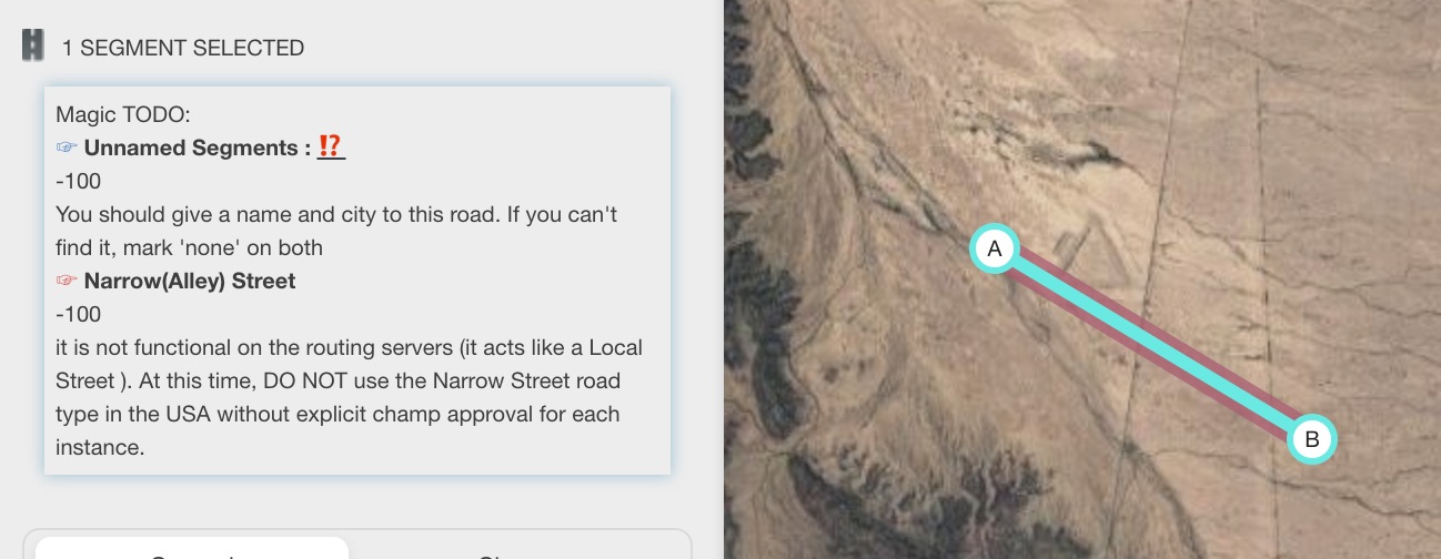
When there is a walking trail connected to some road, WME Magic classifies such road segment as “Simplifiable segment”, what I believe is not correct… There are many examples around, but if you want, you can check this one.
Fixed. I’m avoiding Virtual Nodes for now.
Version 1.1.1 adds HL for alleys (only enabled in the states)
I don’t think we are actually far apart on this issue. You’ll note the first half of my opening sentence:
Hi guys, version 1.0.113 published.
Updated WME code…
Hi gang, i’ve remove the changelog feature as WME has it’s own!
Is it 1.0.113? Mine shows 1.0.118

Dbcm releases many versions and does not tell us change log for EVERY release of WMEMagic. Most likely implementation of very small code changes / tweaks
Latest version is 1.0.119
Mostly are country config syncs or bad deploys…
… or fixing Magic to work with the latest WME version ![]()
Thank you!!!
Version 1.0.20 (or higher) is in the wild.
Added two new HLs.
- aggressive turns (angles < 30º), more or less the same behavior that WME gives on MP (map problems).
- parking lots over each other
1 Like
Those are great additions. The double parking lot is going to be very useful!
Sean