Hi Guys
I’ve been thinking about naming the whole of “State Hwy 1” city field in the south island to “South Island”
The theory would be when you zoom out the only name left would be “South Island”
Thoughts?
Hi Guys
I’ve been thinking about naming the whole of “State Hwy 1” city field in the south island to “South Island”
The theory would be when you zoom out the only name left would be “South Island”
Thoughts?
My view is that the city field should be used in all roads to reflect the area that the road is actually in. If its done properly I don’t see why it’s an issue. When zooming out the area/town names across the country is what you will see.
In bigger cities the field can show the suburb and in smaller towns or rural areas just use the name of the town etc.
motorways in the city should just have the city name.
Where this has been done in Auckland looks good on the map with suburb names being displayed in the correct places. I’ll have to try again but in the past I did an experiment with searching and found that a road with the suburb in the city field can be searched using either the suburb or the city name. Waze knows the greater city name even when the suburb is put in the city field.
Are you sure about this?
I used to think this but now I believe some streets are labelled with the greater city name so it gives the impression that waze knows the greater city name…
I know it used to work, but that may have changed.
I’ll find some roads around auckland again where I can try it out.
This.
I’ve found recently that you can now search without specifying a city and Waze will return results closer to you first. In the past it seemed completely random.
I disagree with this, its fine in places like Auckland where everything is very connected, but once you start going out into the rest of New Zealand the client starts doing weird stuff, for example the middle of the town/city is the middle of all the roads that have that name. And recently ive found largish (50k) towns that are in the middle of nowhere because the city name had the name on the small road.
On top of that as ive mentioned in the other thread when people are setting the city, its based on ‘ive just done this one’, and everything in between doesnt exist until someone fixes it. For example Taranaki had a lot of places like this, Inglewood, Eltham, Midhurst, Patea, even Hawera were all listed as the incorrect towns because someone had done a town/city before it, entered the name and then when someone else came along they didnt update the field. At least if its set as No City it wont cause what the forum calls a City Smudge.
yep, im with “nzhook” on this one
I’ve just tried out my theory on searching using Ormonde Rd in Remuera.
It’s named Ormonde Rd, Remuera (City) and here’s the results based on varying search strings:
I was sure option 3 had worked in the past so either I am mistaken or the search has changed since then.
Searching for roads in Taranaki has mixed results when there is no City field in the road name. for example Upland Rd in Egmont Village is impossible to find in a search. Entering ‘Upland Rd’ alone provides a number of Upland Rd’s around the country not one of them in Taranaki. There is one in the results labelled ‘Upland Rd, , New Zealand’ (with the city field blank) but that is in Kelburn, Wellington.
There are two issues that need to be resolved regarding the City field
What we want to achieve in both cases is
The search-ability should have a higher priority than the visual appearance of names on the map.
I still believe it is best to use a city value in the rural areas and name them correctly. The challenge perhaps is finding the correct name. The Wiki talks about not being able to use Google imagery for copyright reasons (http://www.waze.com/wiki/index.php/Map_Editing_(new_Editor)#Using_External_sources_.28such_as_Google_Imagery.29) - does that include the actual map data as well? It’s very easy to see the boundaries on the map by searching for the town/area name. E.g. searching for ‘Inglewood, Taranaki’ will show the boundary. If the City name is displayed in the middle of an area where it is used, and the roads are named in this way, then where it’s displayed should be appropriate.
Upland road (or many of the country roads in Taranaki) is a bad choice as ive only just named it before the latest map update and the routing server will not have caught up on the names (I dont understand why there have to be so many copies of the data updated before everything in the client works - but thats a different topic)
However the real question that needs to be asked is, is Waze a replacement for a navigation system like Google maps in that you can navigate from Auckland to somewhere you dont know. Or is it a user based traffic assessment app that you use in your local area to get around current problem spots?
Eg. Would I use Waze to find Second Ave, Whangarei when I live in New Plymouth? No.
Would I use to take me to work in the morning and avoid areas where there maybe delays? Yes
(ill also add Would I use Waze to find the fastest way to Second Ave if I was already in Whangarei? Maybe)
If I search for a road in the area im in, Waze will normally return the closest match (which if Upland Road was upto date, would be the one that runs from just outside of Bell Block through to just outside of Inglewood), where as if I was in Wellington it would return the one closer to Wellington.
That also leads into the other question, what is better to have city or suburb. City is helpful from a zoom level further out and doesnt clutter up the map, but as you get closer or start navigating you really need the suburb. This is why I like ispy’s idea of having the city against primary streets and higher, but normal streets have the suburb. Its a pain if the street you want in a suburb is listed as primary, but now that they have added Alternative names back in, it should allow us to have both the suburb name as well as the city name (Only the primary name shows on the map, but the routing server apparently will search for both - once its updated with the most recent data).
The alternative names maybe why it worked correctly in the past, someone had entered them with both names.
For the copying from Google maps, that article is more talking about using it as an overlay. You can use it as a reference if need be, much like you could use a map from AA. You however can not use it to copy the roads (or imagery - which is something that maps Taranaki really hard - no good imagery) directly into Waze without first getting permission from the copyright holder.
And the areas shown in Google maps dont make a lot of sense for those driving the road, take a look at Egmont Village (70k speed limit thru the built up area), Inglewood (50k speed limit thru the built up area), and Waiongana (Theres no built up area so its all 100k)
Personally, if your driving 100k (or Open Road Speed) outside of a motorway then its ‘No City’. Its the easiest option to explain for new map editors, shouldnt cause city smudges, looks correct on the map, and the client should find the streets correctly if your already in the area.
BTW, I would be happy with a town/city entered on all streets if we were doing postal addresses, had more fields to determine the built up areas and suburbs + could guarantee that all the city/towns/villages… were correctly entered.
Both.
But it doesn’t do the first very well. Having said that its getting better.
I just had a quick look at the UK and the section I looked at (secondary highway) didn’t have a city name (no name)?
I Agree. Finding the fastest way between two known points is great for day to day commuting and it’s essential that a good navigation app be able to search and find addresses (or at least streets), and provide the fastest route to get there.
would you suggest that drivers should use an alternative navigation app if they need to ‘find’ an address or street rather than Waze?
Why limit the capabilities of Waze when it can be so much more than just a tool for daily commuting?
So what are we going to do?
We all agree that we need to set some standards?
http://world.waze.com/wiki/index.php/How_to_label_and_name_roads
I don’t think any apply to NZ?
Correct, and thats where Waze shines. It does find the fastest at that time, unlike navigation apps which take you from place A to place B using the proven shortest/fastest route 2 years ago when they were mapped.
No, if the place your looking for is in the area you are then, it will work as it needs to (search for the street name, it pops up the closer results and away she goes). Its when you start trying to navigate 200 km+ that it starts getting sketchy, as the search for that type of distance is crap.
Because its limited by design, you would currently be trying to fit a large round peg into a small square hole and that wont work.
Personally I would love it if people could use it for both, and when we put country, island, state/region, city/town, suburb and maybe even postcode into separate fields, and Waze can search on all/any of them then i would gladly call it a navigation app but until then having a city defined on rural roads is probably going to cause more complications down the road.
However this conversation seems to be focused on having a City against the primary field, ive already mentioned a number of times of using the alternative names, which would mean having No City against the primary, and then an alternative name with the city (or suburb for when City was used in a suburb)? IN this case:
So in major cities we would put the suburb in the primary city field and the city name in the secondary city field. This as you say would ensure a search for either will find the street.
Driving around Auckland at the moment the map looks quite good with the Suburb names appearing in more or less the correct places - except where people have labelled streets incorrectly. If the correct suburb name is put in the primary city field it will work.
If I understand you correctly, your suggestion in rural areas is to leave the city field blank and put the correct name in the secondary field to aid searching - is that correct?
Like this?
That would look real nice
Thats a big job but think how many easy points you could gain
I was thinking the other way round - Suburb in the primary and City in the secondary.
Especially in the bigger cities that would look great with the suburbs showing on the map.
It’s great being able to add secondary names so easily!
Yes to the rural, No City for the primary entry and the city in the alt.
As for the City/Suburb side, the client only shows the primary. So the rule would eb something like:
Primary Street or higher = City Primary, with Suburb alt
Normal street or lower = Suburb Primary, with City alt
That should then allow for the zoomed out view to show the City, while when you get closer to see the suburb.
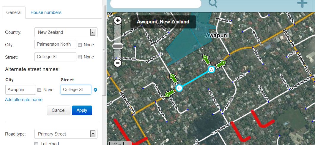
BTW, pcp Collage street in Palmerston North is a primary street. So what isp has done is what we are all thinking now (I hope)
I quite like the ideas, but given the potential volume of change would it be best to “proof of concept” it first, and wait until a tiles update to see what it looks like in practice?
Maybe pick a rural area with lots of the classic kiwi crossroads “village” and set the alternate names, and then in a smaller city do the motorway/primary=city, others=suburb?