As we received many requests and suggestions to improve the toll tool, we thought it would be a good idea to update all of you with the tool improvements and the suggestions that are currently under consideration in here! We also want to take the opportunity to hear new suggestions in this post Please be aware that we are doing our best to push forward all of your requests for improvements, but some things might take a bit of time and/or get prioritized
IMPLEMENTED IN JULY
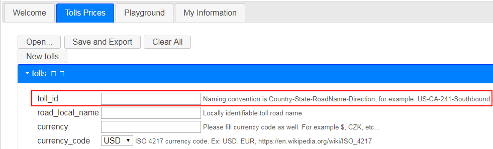
Friendly Name for entry/exit matrices for the same road (e.g. normal rate, peak rate, holiday, etc)
Replace CAV with EV
Search for file by road name, file name & username
Auto-populate for segments
Hover over file name reveals toll road names in Load tolls screen
Many other small UI suggestions were also implemented (:
GOOD IDEAS
Add HOV Pricing
Add max price per toll id
Population tool should work with “toll-free for motorcycle”
Add a Pop up or a message that shows you successfully saved a file
Move the permalink to be first in the segment tab
Ability to search by segment
Ability to drag sections into different order
Give the Community the ability to upload a file in production.
Add map problems dedicated to pricing: This will make the information exchange between drivers & community much more effective.
Flagging in WME if a segment is mapped to a toll price: Currently community has to add very high lock levels and add map comments to help people understand not to change seg ids (cutting/merging etc.)
Dynamic Pricing
Add a stop functionality
NOT RIGHT NOW (OR NEED MORE INFO)
Function to increase all prices by a constant amount or percentage
Single section discount
Receiving an automatic email with segments that have been changed (split-merged) that involve toll roads
Map Stats: Ability for everyone to see what is already uploaded/saved as public on the map & maybe stats on number of segments mapped to the tool, roads uploaded per country
Launch WME view: From the playground tab create a button which would launch WME centered at the current center of the playground map. Something like "Launch WME for Current View” →[i] I just want to clarify that you can currently see the WME toll segments by clicking “ Show Waze Toll Segments for current view”[/i]
Logging in with your Waze account in toll tool
Zero-dollar toll for entry/exit combination → [i]please send us specific examples[/i]
Huge interconnected networks (i.e.: France) → [i]We are working with communities to try to understand the challenges better. If your country has one of those huge interconnected networks you don’t know how to map, please let us know[/i]
When reversing the polyline for the other direction, checking via “draw” it is not visible which direction it is.
Reservation required (for ferries) - It would be nice to be able to display “reservation required” next to a toll price.
Thanks to everyone who sent over the suggestions and for the great engagement and excitement that all of you are constantly showing about this feature!
Hi Tamar, I had emailed toll prices support with a suggestion to add a “reservation required” checkbox in the tool and corresponding banner in the app. This is useful for certain ferries. It would enable us to map them normally and give prices, so that drivers could decide whether to book before they go.
Since tolls include components from WME and the Toll Tool to be “integrated” - and WME Tile updates and Toll Verification/Uploads are dys-synchronous from each other, I am wondering what can be done as far as change management when updates are needed, either because toll prices are increasing, or because there are changes in road structure or tolling structure. Well coordinated uploads of Toll files (or possibility of community upload as suggested) would certainly be welcome.
I think of this as I’m thinking about changing a toll structure from existing two one-way directional files with Matrix in/out formatting, into a single bidirectional in/out matrix file for easier long term maintenance. But this conversion would also require changes in some WME segments. Without tight coordination between the Tile updates and Toll upload it could be days or weeks without toll prices if this sort of update is made.
As a start I think it would be good for us to have notifications or ETAs on when Toll uploads are planned. OR we could request in advance a Toll upload date, or have a way to specify an activation date for an update Toll file, and have a way to specify a date that an active Toll file gets replaced by a new one.
I would recommend that the map used to make the POLYLINE have the search option. This would facilitate the initial location of the toll through the use of reference points.
Allow the Playground to generate routes based on Waze roads rather than Google Maps.
I had a situation where a new bridge span was added and a new toll was placed. I created a parallel segment for the new span with appropriate RTC dates to control which was active. I was unable to test in the Playground because I couldn’t get a route over the new segment.
In these cases, wouldn’t you want to adjust which toll segments are entered so that it can be used as a non-toll route? In other words, you should change which segments are tolled so that users with “avoid tolls” can use the free route. I wouldn’t want to see a toll flag - even if it’s free - with avoid tolls selected.
Here is an example in New York (prices attached). There is a free “toll” from Exit 25A to 24, 25, or 26. But trips to/from any other exit than have a toll (even 24 to 25). We want users with avoid toll to be able to drive from Exit 25A to these other exits, as Exit 25A to 24 is around 20 minutes faster on the highway than the side roads), but still have a toll for everyone else. So we implemented tolls on the entry/exit ramps on the directions not used by the “free” toll.
We do get a UR once every few months by a user saying they were put through a toll booth, but they learn at their exit that it was free, and the responses have generally been thankful when we do get a UR reply.
You could still have a $0.00 toll price show, but without a toll segment to trigger the system, it wouldn’t load. We found it more positive to have no toll segment and deal with the URs that come in, rather than falsely have a toll flag and an additional 20 minute drive.
Hi Everyone
Thank you for all your messages!
Please see my answers below
Hi Kartografer
You are right, we received such a suggestion and I added it to the original post
I apologize for the inconvenience and thank you for bringing this up
Ideally those files would be uploaded directly by the community (as I mentioned in the original post “Give the Community the ability to upload a file in production”)
Good call, I will add it in the backlog of the suggestions in our side
Even though the playground doesn’t look like Waze, it uses the Waze routing, so the routing in the playground is updated with the tile update.
If you see a difference in routing between the app and the playground then please let us know.
Thank you for the example
I will forward it and keep you update in the next update post!
Thank you again to everyone who sent us suggestions for improvements
Tamar
Can we get the warnings / errors that show on save to text wrap in the pop-up box, it is extremely difficult to read and understand the warnings when you can’t see it all :!:
It would be nice to have the name of the toll file somewhere in view while working, so no need to repeat the general info in every toll entry
it is better keeping overview if we can have a more specified name in the various toll entries of one file. Adding the general part make long names and makes it unreadable without scrolling.
For time-based tolls, where a road charges a toll to everyone at certain times but is free at other times, there is no way to enter these into the editor without a hack. The least hacky way is to make a toll-free restriction for the times when the road charges a toll, and to select a vehicle type that can’t and probably won’t be used in the app, such as public transportation or bus or truck. We have to do this, because WME doesn’t allow us to save a toll free restriction that applies to nothing. Can we get WME to allow toll-free restrictions that have no criteria except for valid times/dates, so that there’s no need for this hack?
I know that this is more of a WME suggestion, but Daliah asked me to post it here since it relates to toll pricing.
The only thing you avoid with the hack is a toll penalty in routing. For the prices you can enter the times. At free times, it will return 0 (or nothing’)
An alternative workaround for routing perhaps is to make an extra road (2 segments) without toll mapped under the other one, open at the times when it is toll-free. Scripts like validator and magic will give a warning, but it solves the issue.
Yes, entering prices of 0 is also necessary, in the case that someone’s route includes a toll road somewhere else. We don’t want the default price of the part-time free road to be added onto the price of the other toll road.
A penalty is applied to toll roads even for users who don’t have avoid tolls on, so that can make a difference in routing. Of course the “avoid toll roads” penalty makes a big difference. Other hacks can be employed (thanks for yours), but I’ve been advised to see if staff will fix things before resorting to hacks. So I’m suggesting this, now that we have the interface to support it.
at level of “Tolls” confirmed:
it searches Toll_ID and road_local_name.
However, all sections need segments with nodes populated. 1 faulty or missing and it doesn’t search the whole file.
at level of “Sections”
It searches fromNode, toNodeand the segment_ID,
but NOT the Section_ID
Strongly suggest to also include Section_ID in search. Especially in case of broken segments we can still easily find the intersection or toll booth by name.
Unfortunately, a Champ changed some segments in his managed area, without knowing that some segments were included in the country-wide tolls project.
I’ll have to check in WME for every single segment in all uploaded files to find which segment IDs were removed from the map because of the merge (trying to reduce the number of nodes), and find the new ones (or split them again).
OR, a periodically generated report of removed segments would help on this SO MUCH!!! Just include the URL, section name and other relevant info from the JSON file.