My name is Felipe Silva, and I work with Transdev Ireland, the operator responsible for managing the Luas tram system in Dublin.
I’m reaching out to seek your support and guidance regarding the Waze Maps platform. In Dublin, we are experiencing a growing number of incidents involving pedestrians, cyclists, and road vehicles at shared tram junctions. As part of our ongoing efforts to improve safety, we would like to introduce a fixed sign or alert on Waze to notify road users when they are approaching a tram crossing.
This initiative has been successfully implemented in other cities where Transdev operates, including Doha, Qatar. However, we’ve found that we are unable to make these edits directly in Waze for the Irish network.
Could you kindly advise us on how to proceed? Specifically, we would appreciate any information on the appropriate contacts, procedures, or guidelines to request the addition of tram crossing alerts to Waze in Ireland.
Your support on this matter could make a significant impact on the safety of Dublin’s transport network for both our passengers and all road users.
Thank you in advance for your assistance. I look forward to your response.
Best regards,
Felipe Silva
Transdev Ireland
felipe.dasilva@tdlr.ie
Can you tell us what kind of alerts Waze shows for shared tram junction in other countries? Are the same as the alerts for railway level crossings, or do they have a different appearance?
Note that Waze only supports private car drivers and not pedestrians or cyclists.
While it’s technically possible for us to show alerts for railway level crossings, we’re not sure about showing alerts for tram junctions, because these have no barriers and are controlled by normal traffic lights (from the point of view of cars; I know the tram drivers see a different kind of signal).
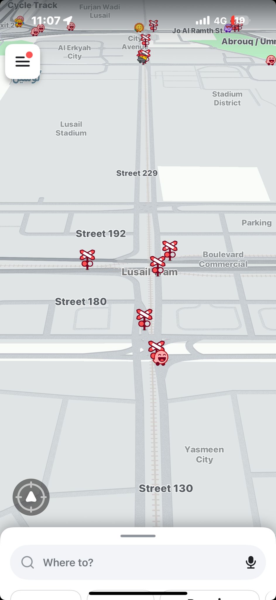
Can you tell us what kind of alerts Waze shows for shared tram junction in other countries? Are the same as the alerts for railway level crossings, or do they have a different appearance? - In Doha, Qatar, for instance, Waze displays alerts for railway level crossings, accompanied by a specific icon on the map (please see the attached screenshot for reference).
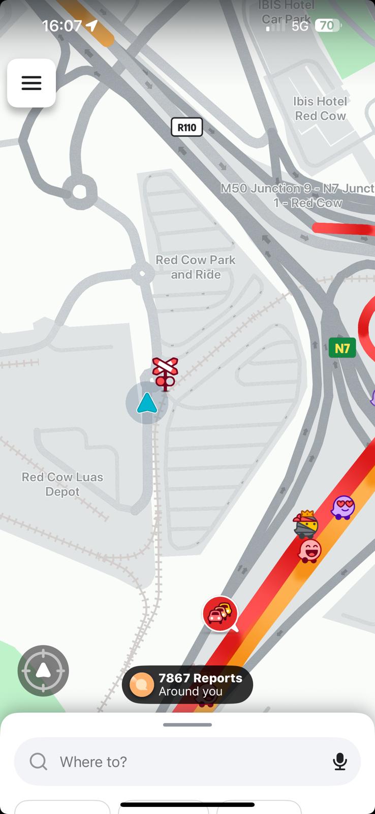
While it’s technically possible for us to show alerts for railway level crossings, we’re not sure about showing alerts for tram junctions, because these have no barriers and are controlled by normal traffic lights (from the point of view of cars; I know the tram drivers see a different kind of signal). - This is the core issue: tram junctions are fundamentally different from railway level crossings. In Dublin, these are operated by Dublin City Council through traffic lights. Unfortunately, we’ve seen a significant number of incidents at these junctions caused by drivers running red lights. Our investigations reveal that approximately 75% of these incidents involve drivers from outside Dublin, unfamiliar with the area and relying solely on satnav guidance. - To help mitigate this, our idea is to introduce a unique alert such as “Tram Crossing Junction Ahead”. This would serve as an additional safety feature—raising awareness, preventing incidents, and contributing to a safer road network across Dublin. - We’ve observed a practical example of this in action: in front of our Head Office at Red Cow, there is a Waze alert that marks the location as a railway level crossing (screenshot attached). While this was not implemented by us, it has significantly reduced incidents at that site.
With that in mind, we have two questions:
Is it possible for Waze to create a distinct alert type specifically for tram crossing junctions? Referring to these as railway level crossings would be misleading.
If a dedicated tram alert isn’t feasible, would it be possible to replicate the existing railway level crossing alert (as used at Red Cow) at other key junctions, simply to raise driver awareness—even if the label isn’t entirely accurate?
To answer one of your questions: we can’t do a dedicated alert type for tram crossings, but it is possible to do railway level crossing alerts (we’re just a team of volunteer editors in Ireland: we don’t have any control over what features Waze might (or might not!) add to the app)
We’re just debating amongst ourselves whether to map alerts all junctions containing Luas tracks; we’ll make a decision soon.
Thank you so much for the updates. I really appreciate your feedback
I was under pressure to give some answers internally.
Waiting your feedback later on.
Sorry about the delay getting back to you. I’ve discussed this with the rest of the editing community here in Ireland, and we’re reluctant to place these kinds of alerts everywhere there’s a road junction containing a tram line. The alerts are quite distracting to drivers and obscure turn instructions while they’re on screen, which is why we don’t like to show alerts any more than is necessary.
However, you mentioned one at the Red Cow Luas depot, which we did add as an experiment last April. We also added many others at the same to parts of the red line, especially south of Red Cow.
Although that was only three months ago, it would be interesting if you could monitor accident rates between private cars and trams since for a decent period of time and compare these accident rates to before the alerts went in. If you can provide compelling non-anecdotal evidence that these alerts really do have a statistically significant effect on accident rates, then we can reconsider.
We’re certainly not opposed to improving safety, but we are quite conscious that the alerts themselves have the potential to cause distraction and that many drivers find them annoying.
Thank you very much for your response. Transdev Ireland greatly appreciates the volunteer work that you and your team are doing – your efforts are truly valued.
We understand the concerns regarding the alerts and the potential implications, as outlined by you and your colleagues. We are happy to proceed with the proposed approach: monitoring incidents at locations where signs have already been implemented and reverting to you once we have gathered sufficient KPI data to assess the results of this initiative.
However, we would like to highlight a critical point: our two main junctions, which are responsible for approximately 70% of reported incidents, currently have no alerts or signage on the map. These are:
A29 Junction: Benburb Street × Queen Street A21 Junction: Davitt Road × Suir Road
These two junctions pose the greatest safety risks to Luas operations and have recorded the highest number of collisions over the past 20 years.
We believe that adding alerts and signage at just these two locations could have a significant positive impact on network safety. It would also provide us with a meaningful opportunity to analyse the effectiveness of this implementation using a well-documented historical baseline.
Would it be possible for you to review with your team the feasibility of adding the alert feature at junctions A29 and A21? From there, we would propose initiating a six-month monitoring program to evaluate the impact of the newly added alerts and signage.
Additionally, if you could share a list of the locations where alerts and signage have been implemented since April, it would be extremely helpful for us to begin a structured monitoring program in those areas as well.
Once again, Transdev Ireland sincerely appreciates your ongoing support and dedication to improving the safety of road users in Dublin.
I’ve mapped level crossing alerts at those two high-accident-rate locations. Please monitor these and let us know if there’s any significant impact on accident rates here (the alerts will go live in a couple of days).
We appreciate your attention to this matter.
It can have a huge impact in our operations. In 6 months time we will generate a report collecting all the data from the next semester to analyse the impact of those alerts in these two locations.
If you guys have the chance, one last request:
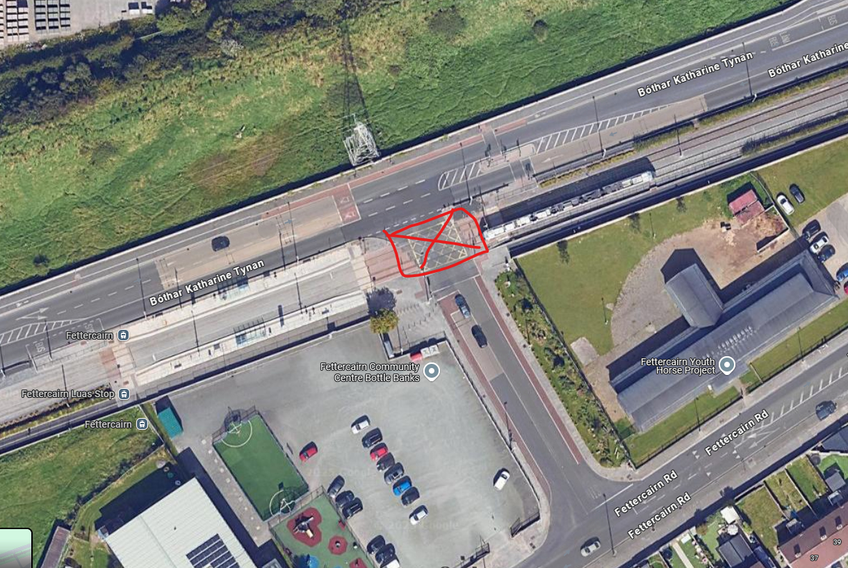
If you could add the junction A105 which is located at Fettercairn platform on Bothar Katharine Tynan X Fettercairn Link Road. (See map below)
This is our third big location if you analyse the map, most trucks coming from N7 (North) and N81 (South) Road often hit the tram in the level crossing. If you could also add on this one would be the perfect scenario.
We have monthly meeting with Governmental Regulators (TII, CRR, NTA) and we will bring the news about your action and support.
Before we add any more junctions: can you share some statistics with us about the incident rates at these three locations, and also what kind of event counts as in incident? Presumably a collision between a vehicle and a tram, but perhaps other kinds of event?
Finally, please note too that Waze only supports private passenger vehicles and taxis. Other vehicle types (such as delivery vans and trucks) are NOT supported. I think trucks typically have their own GPS navigation systems which would support low bridges and tight corners that trucks need to know about.
If trucks are involved in collisions at junction A105, Waze alerts would have no impact here, because trucks should not be using Waze.
Please note too that the Waze map is maintained by volunteers who do this in their own time (as a kind of hobby). That means that, although we do our best, we can’t be 100% accurate at all times, and the level of accuracy depends on which volunteer editors have time to look at a particular area.
Sorry for the late response, I was on Annual Leave.
Coming back now, we are more than happy to share some statistics about the junctions.
Considering the sensitive data, do you have any e-mail that I could share those KPIs?
In time, we notice that few more junctions around the network have now the alert of rail crossing settled 500m before the approach. Could you confirm if it was applied by you guys?
This is a huge improvement and we will start monitoring the KPIs to track the impact of this action.
In advance, we would like to thank you and all volunteers involved in this process. In 6 months time we will provide some data for you guys and we can discuss once again this subject.
You can send the statistics to wazeiecms@gmail.com — that will go to the volunteer country managers for Ireland.
As for the distance at which alerts show up: this is determined automatically based on the speed of the approaching vehicle: the faster you’re travelling towards an alert location, the further away the alert is shown (because it takes more time to react if you’re moving quickly, of course). We don’t have the facility to manually adjust the alert distance.
Now that six months have passed, would you have any statistics for us about accident rates at the locations we talked about? That would be useful to see whether the warnings about level crossings have had any effect.
Felipe very kindly sent on the results of the study a few weeks ago, but I haven’t had a chance to look closely at it yet. I’ll post here whenever I get around to it…