Following recent discussions in about Places, Car Parks and Petrol Stations, I’ve put together this list of guidelines for mapping Places. This should be read in conjunction with generic Wiki page about Places.
They’re not wrong if there weren’t any guidelines at the time
The brand should appear in the search results, and Waze have said they will put that back in “soon”. Ergo, it shouldn’t be necessary to put the brand as the name of the place. Petrol stations often have a proper name, some better known by locals than others. You may find the petrol station isn’t displayed on the building, and supermarkets are particularly unimaginative.
Search results also show which road the petrol station is on (or off of), so that should aid differentiating between stations on opposite sides of the road. YMMV.
I’m happy with “Stn” as an abbreviation.
Meh. Users can submit that information from their cars…
How would this retail park be mapped? The retail park itself doesn’t have a name as far as I’m aware. If it did, I’d remove the car park Area Place, put an Area Place that covers what’s currently mapped as two Shopping areas and name that as the retail park name and add Point Places for the individual outlets. Should the Area Place in this case be left out, or unnamed?
There aren’t any plans to change them. Is there any advantage to doing so?
In this specific case, I’d suggest it was fine how it is (without the car park) given the size of the businesses involved. “Crawley Leisure Park” to the south could have some points added.
:? Confused. The draft says “Enter the name of the building as the street name for the point places within it.”, whereas the current guidelines say “don’t name them”. (I don’t think the PLRs should be named.)
I mean, set the “street name” in the address of the Point Place to be the name of the shopping centre.
This is mainly for very large shopping centres / malls which have their own name and are more well known that the roads they are on.
For example:
Trafford Centre - area place - address is B5214 - Trafford Blvd, Manchester
John Lewis - point place - address is Trafford Centre, Manchester
Parking lot roads remain unnamed
Is that over complicating things?
Is there an advantage of setting the Street name of a Place? A new place picks up City by default. If there’s no advantage my vote would be to leave it as optional.
How do we map a shopping centre with an integrated car park above or below the shops? Do we just take the roads to the edge of the building? Examples at St Davids and John Lewis in Cardiff
That’s an interesting question, and one that should be noted as an exception. Navigating drivers to the entrance is probably sufficient, especially as they’ll have zero GPS reception if parking is below the shops.
Just thinking, how about a Place (point) at the/each entrance to the car park labeled ‘[P]’ alternative name also marked, for example ‘NCP John Lewis’?
Yes, points can work well for car parks. They appear in search results but don’t obscure the map.
I would prefer it to have the full name though, i.e [P] NCP John Lewis. I’m unsure about keeping the [P] bit though, as the category search for parking has it’s own special P icon.
Would it be a good idea for petrol stations (at least) to include the road classification in their “street”? And where it can only easily be accessed from one direction, put that direction in the street name as well, even when not present in the adjacent road. This would cause the “navigate”->“fuel” list to come up with
rather than just
I think this would make it a lot easier to pick out the most convenient station to refuel at, and sometimes also help pick the right one of multiple stations when updating prices.
I’m going to suggest something more radical: keeping with the ‘don’t drive inside landmarks’ and ‘only map buildings’, how about these extreme rules for mapping Car Parks?
Only map public, general purpose car parks, not tied to any specific businesses
Will also allow Airport Car Parks / Drop Offs, as they’re never confused for in-town parking
This means no car parks for supermarkets or shopping centres!
Only map car parks as Points, not Areas (unless a multi-storey, which is a building you drive in)
Points place at entrances to the car park, with minimal PLR segments as per usual
Always labeled with their full name as written on the sign, e.g. George Street Car Park
Never use [P] text at all, ever!
Rationale is thus: keep the map free of clutter, and only showing actual, physical ‘landmarks’ in the true sense. Users can search for a car park near them (or near their destination), and be sure to get one they can actually park in. The [P] flag isn’t necessary in the search results.
A counter argument might be that people thing that drivers should be able to look at the map to find parking, but that doesn’t seem practical to me.
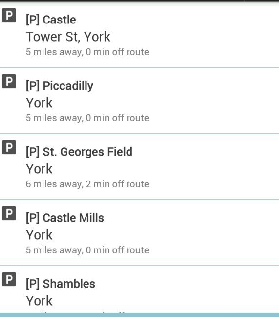
To illustrate my point, here’s what the user sees when they search for ‘parking’ or ‘car park’ when they already have a route set:
Look how naff the text Ps look next to the icons, and there’s plenty of space to add the words ‘Car Park’ on the end of each. Extra information like long/short stay, free and NCP would be useful additions.
Of course, when the user searches for ‘car parks’ or ‘parking lots’, they get a generic search that contains any old landmark that vaguely matches. We can probably fix that with translations, but I’d guess that adding ‘Car Park’ to actual car parks would help them be found for more queries.
There are a number of missing categories in your note (which had left me scratching my head trying to decided what to do). What’s the current preference for categorising Community Centres, Garden Centres and Newsagents - and can this be included in your guidance note
I’ve tweaked my draft document to include a few of the points raised so far. I’ve not (yet) added anything about turning ALL car parks into Points, as I’d like a few more opinions on the matter first.
I do strongly believe that unnamed car parks are completely useless to anyone, and I will happily delete any that I come across. :twisted: