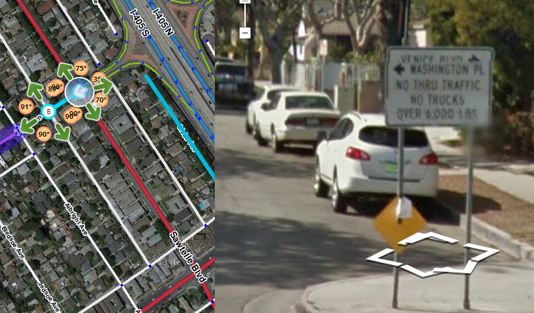
Exit from the ramp shows that you cannot go to Matteson Ave.
That is incorrect,
There is restriction there for trucks,
however normal cars are allowed to enter Matteson Ave.
I took a look at the sign that’s posted at the entry to Matteson across from the freeway off-ramp. It’s true that the only full prohibition is on trucks weighing over 6,000 lbs, but it also says “No through traffic”, which indicates that regular vehicles are allowed to proceed to destinations within the immediate community to which Matteson leads, but not to use it as a path to points beyond. It is a regulatory sign (black on white), which means that it is theoretically enforceable.
Getting Waze to route only into that area, but not beyond it, would be tricky. I’m going to study it, and see if there’s a practical way to accomplish that through the use of Private road segments, but I don’t think there is an idea answer to this one…
It is covered in Private Installations.
I believe we need to mark each street segment inside the Primary, mH, or MH square as private (not the highway segments themselves.
I can’t tell you how many times I’ve looked at that sign and tried to figure a way to do it. If I remember correctly, I even drew ottonomy’s attention to it last year, and we ended up stumped then, too.
@kentsmith9, the thing is, it’s not a gated/private community. Everything there, and all other “entrances” to the Big Block are regular local streets. I believe the intent of the sign is simply to discourage freeway exit traffic from using that neighborhood as a route to Points Elsewhere (specifically, taking Matteson as a shortcut to McLaughlin Avenue). This was also probably the genesis of the “roundabout”/traffic calming circle at the first intersection on Matteson. Privatizing the whole Big Block would work for the purpose of that one intersection, but would then unnecessarily restrict all other paths routing through that square area.
This is why I’ve always chosen to just restrict the straight turn and let people who live there ignore Waze and drive through the intersection.
You can test this out with some map changes and then check the livemap after the next update. The private roads setting will prevent crossing the segment unless the destination is in the group of private roads. You don’t need a physical gate for this to work like a gated community.
Just know that a sign saying no through traffic is enforceable as a traffic violation, so IMO it would be better to try to restrict the traffic.
Yes, I well understand how private installations work. I’m saying I don’t think this case warrants it.
Setting all of those streets within the “square” as Private would indeed tend to prevent freeway exit traffic from traveling across that neighborhood, but routing between these two segments on Venice and Washington Place, mid-square, for one example, would then become an around the Big Block route, rather than straight down Bledsoe, or straight up Minerva. A route from McLaughlin straight across Matteson to the I-405 S onramp, which is NOT prohibited by any signage, would also become a “round the Big Block” route.
You may also note in Street View, that there is not similar signage preventing the N/S traffic on Sawtelle from entering that street, (I could be wrong, but I don’t believe that one sign is CVC-worthy to limit those turns-- can’t reasonably read it until you’re mid-turn) and in fact there is a Left Turn Arrow Signal on northbound Sawtelle. This reinforces the notion that simply restricting exiting freeway thru-traffic is the intent.
I’m not at all saying the “neighborhood entrance” at the ramp intersection should be unrestricted, I’m saying that a simple Red Arrow (the way it is right now) solves the greater problem while inconveniencing the fewest (residents of that immediate neighborhood, who also benefit the most from the restriction), to the tune of ignoring Waze’s instruction to turn left or right there and proceeding straight through the intersection with privilege. They can know/learn better, because they live there. It’s not perfect, but IMHO it’s a much better solution than making all other routes across that area off-limits.
And what’s not immediately apparent to anyone who hasn’t driven these streets during rush hour is that a route around the block-of-blocks via the big boulevards can literally be a 45 minute undertaking at 5PM, so badly do these streets get gridlocked adjacent to the 405. Legal paths through the neighborhoods are important to preserve, so that Waze has some options when things are at their worst.
Another thing which I just realized, when looking over this particular grid, is that it has a network of alleys, currently set as Parking Lot Roads. If the streets were set to Private, would Waze still be able to penalize routes over the PLRs (they sharing the same penalty properties as Private)?
I understand PLR and Private have the same penalty.
The sign at the front of the entrance of the neighborhood shows that through traffic is a moving violation.
Therefore this inner neighborhood needs to be set up as a private installation per the Wiki guidelines.
Kent, there seems to be a serious disconnect here. Please listen carefully to two experienced editors who know this neighborhood firsthand.
The salient point here is that this is not a private installation by any stretch of the imagination nor of the Wiki page.
It’s not even an installation. It’s a regular PUBLIC city block. These are all public streets.
The intersection under discussion is not a “front entrance”, it is one of twelve “entrances” to the block (not counting alleys).
This is one turn restriction at one intersection. All other turns at all eleven other “entrances” to this block are completely unencumbered. No movement other than the Freeway exit to Matteson has the “Thru Traffic Only” restriction.
If you can show what I’m missing on the Private Installations page which applies to this situation, I’d be happy to see it.
I see the confusion. I know there are no gates, controls, or other physical means to restrict access, but the sign is actually serving that same purpose: restricting access to locals only. In this thread we just discussed an identical situation and the Private Installation guide is the solution we use for these situations.
What is needed is an addition to the Wiki to cover this condition. The configuration used in a private installation will produce the same results as we need here, preventing Waze from routing through traffic into those roads.
I started a discussion on this pending Wiki change here if anyone would like to add their comments.
Kent, I think that all of us in this discussion actually have the same basic point of view. You can see from my post here that I advocate the use of Private road type in some situations where public roads need to be avoided by Waze for through-routing. In that case, there was a single street at issue, and clear signage on both ends prohibiting through traffic. I was also the one who brought your attention to this thread, as I was myself pondering Private options for reducing traffic through this neighborhood.
It was tonestertm who originally placed the TR from the freeway exit to Matteson, which set off this thread in the first place. From that, I think you can tell that neither of us has the point of view that public is public, and damn the signs. In fact, we respect them.
I just don’t see the situations in the two threads as being identical. The signage here does not restrict traffic from any direction but from the freeway. The TR may not be an elegant solution, but it is effective, and I don’t think that the single sign, clearly designed exclusively to shield the neighborhood from freeway exit traffic, warrants closing off the whole area to through-routing.
As tonestertm pointed out, none of the other intersections bordering this neighborhood have any signage whatsoever, or even a hint of a traffic calming device, for that matter. The city of Los Angeles is unambiguous when it wants to keep traffic on the main streets. They extend curbs, put up No-Turn or No-Entry signs, making certain streets exit-only. Here, we have no such thing, anywhere on the perimeter, with the exception of the intersection with the freeway ramp.
But I don’t think either one of us would argue this particular case so tenaciously if it weren’t for the fact that the principle could be equally as well applied to ANY residential neighborhood in the parts of LA where traffic gets horribly backed up, and drivers try to find ways around things. Finding those routes is the very purpose of Waze, where they are legal. Our point here is that this neighborhood is no different from thousands of others, where the residents would be equally as pleased not to have extra cars running down the streets. But that traffic is part and parcel of owning property in LA.
If we restrict this neighborhood, I can show you hundreds of other, better candidates, but I believe that we need to use the actual signage and official traffic controls as our guides, or it becomes a horribly complicated judgement call on the part of the editor. This is not a private or unified community. That does not alone tell me that we shouldn’t use Private segments within it. But it does not have limited entry points in any respect, and there is not the slightest indication that the city has any plans to change that. The turn restriction now in place does exactly what the city had in mind with their single sign. Private segments throughout would be massive overkill here, in my opinion.
None of the foregoing is in argument with the basic concept of using Private segments in public places where doing so will make Waze route appropriately. I stand behind you 100 percent in principle. It’s merely the specifics here on which I disagree, because I can’t find anything that makes this neighborhood different from thousands of others, and I don’t think we should potentially start a crusade to eliminate all Waze routing through residential areas.
To summarize: The problem is that one entrance has through traffic restrictions, but others do not. So we do not want through traffic coming into this segment, but we DO WANT to allow through traffic to shortcut via other entrances where it makes sense. Marking the entire community road network match private installation would prevent the latter usage. Therefore there is no good solution for preventing traffic routing that violates this one sign, which is unfortunate, especially as a driver may not realize this is the case.
However, in a nod to the probably intent of the sign, a turn restriction from the freeway has been added, which has nothing to do with our usual procedures. It is probably helpful, in that the majority of traffic coming through that turn should not be making the turn, though that does needlessly restrict local traffic (both visitors and residents). Hopefully, resident Wazers will know intuitively to just ignore Waze’s routing instruction at the exit, and if we are lucky, will also inform guests that when they exit the freeway they should just enter here.
I hear what you guys are saying and I will note that I have recently made a reply to the key points of your concern in the “No Thru Traffic” thread I started to consolidate the discussion and keep it for easier future retrieval.
On the point of restricting traffic from the freeway to that street, you are preventing the people who live there from being able to get to their own house. You will get URs from them and MPs from the routing engine saying the turn must be wrong.
I propose we continue this conversation in the other thread since it is more universal a question and not a specific LA Lock 5 issue. ![]()
Responding here, just to reply to specific points, and because it is specific to this situation.
This TR has been set to restrict Freeway traffic (as it currently is) for approximately a year. This is the First comment of any sort that I’ve seen there (not that I couldn’t have missed something, to be fair ) . Before that, the sheer volume of traffic coming off that offramp developed URs regularly, when Waze tried to route through there. Now, it wasn’t set to Private then, so this is not any sort of proof, but the number of Wazers who live in that city block can probably be counted on two hands, if that. So, if we get an occasional MP (which I have yet to see there) I think it’s a win, compared to the number of URs and MPs we would get by turning everything Private and denying all the shortcuts through there.
I blame any errors on tapatalk… ![]()