Updated segment data guidance for US

Hello Wiki-sters,

I’ve been out of the Waze documentation game for a while, so I’m posting this here to find out next steps for updating the wiki. Based on a poll in the US State Manager forum, accessible by SMs, RCs, CMs and Champs alike, we have voted to make the following standard/guideline addition:

Affects: Any segment which 1) has a delivery address specified by the United States Postal Service, and 2) has primary segment City name which is different from the USPS address.

Standard: There shall be (an) alternate street(s) defining the USPS street/city combination.

For example:
Screen Shot 2016-11-12 at 10.32.25 AM.png

Why: addresses for which we have no City defined in Waze (for map visualization purposes) are not searchable in Waze using a House Number nor a Residential Point Place.

I have documented several Q&A which may be of use, but not sure how that will fit in the wiki, or where. But can provide those on demand. (They are in the thread linked above.)

For those of us without access to the thread you linked, can you please put the Q&A in here?

As the poll and associated guidance are relevant to the us, this proposal should be made in the US wiki forum. Perhaps a forum mod can move this thread there.

Michael (Kartografer) and I are going to be collaborating today/tonight on a draft, and will post it here for discussion ASAP.

Here is the QA post quoted.

One of the things I think is important, is going to be guidance on how to find the USPS city. From what I’ve found, that isn’t a very easy thing. Zip code maps are all over, but USPS delivery city for an address is hard to find.

So far, I’ve used https://eddm.usps.com/eddm/customer/routeSearch.action successfully, but it is not terribly friendly.

TIGERweb from the US Census Bureau is one of the easiest ways to see both city (corporations and CDPs) and ZIP code boundaries, and I think the original Waze city layer may be based on its data. Just check the ZCTA box to see ZIP codes. Once the ZIP code is determined for an area, the default city can be found using the USPS ZIP code lookup tool on the cities by ZIP code tab.

OK, the text for the proposed guidance is below. It’s also hosted with images on this userpage:

https://wiki.waze.com/wiki/User:Machete808/Editing_city_data_to_improve_search

Please do respond with any corrections/suggestions that could clarify my admittedly limited understanding of the issue. Also, Kartografer is proposing combining this with the existing guidance on duplicate cities for a more unified city page, so any thoughts on that prospect will be appreciated. Thanks!


Editing city data to improve search

To keep city names from sprawling over too wide an area in the Waze app, in WME and LiveMap, editors follow standards of placing the city name on segment details only within the boundaries of the city polygon. That means many addresses on the map are in these “no city” areas, particularly in rural regions.

The search problem

An editor can create a Residential Point Place (RPP) in the correct location with an accurate address, but Waze may not route to the RPP if the city is not on a nearby segment. It will turn up under the “more results” tab in the app, but will be listed without a city and thus unlikely to be chosen.

Waze search defaults to best match of search terms, whether they’re entered in search fully or selected from the autofill results. If the Wazer enters or selects a postal address and there is none on the Waze segment, Waze will go to its Google backup data that matches and will route to that pin. That’s not always optimal, especially in rural areas or other locations where the destination is some distance from the named road.

There are sometimes multiple city names in use for an area — a municipality or a Census Designated Place (CDP), in addition to the postal address.

But because many Wazers will search for a location by its postal address, U.S. management has established an editing standard to include the city designated by the U.S. Postal Service as an alternate on segments having no name, or a conflicting name, in the City field.

For example, these images show a discrepancy between Waze RPP and Google coordinates, and where the Waze app puts the search result. The example shown in the images is 10020 SW Grabhorn Rd, Beaverton, OR.

The solution

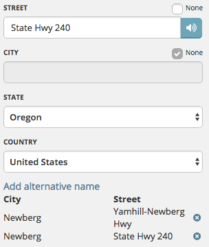
The city has now been added to the segment off the main road closest to the RPP. NOTE: In order to add an alternate city to an unnamed road segment, it’s necessary to put the street name of the address in the primary position, and then save, to get the option to add an alternate. The street name can be deleted from the primary after the alternate is in place.

The improved navigation result can be seen in the final screenshot from the app.

There are other standards in place for other purposes requiring adding other street data in the the alternate. The addition of the USPS data does not change any other standards but is in addition to anything existing already on those affected segments.

Identifying the correct postal city

Editors should use official USPS tools to check the city. If you know the ZIP Code, the city can be looked up here, or entering a city believed to be correct can be verified:
https://tools.usps.com/go/ZipLookupAction_input
Every Door Direct Mail, a mapping tool from USPS, produces a map with ZIP Code boundaries:
https://eddm.usps.com/eddm/customer/routeSearch.action
TIGERWeb is an online service of the U.S. Census Bureau:
https://tigerweb.geo.census.gov/tigerweb/

I made the address in the example be a link to the WME PL for the RPP. I removed the S from the httpS in the source links at the bottom.
See the change comparison here.

Thanks for this. I’m hoping to hear input from others, too, on which tool(s) they find most useful. I have to admit, I lack sufficient practice with all of them to make a good recommendation, so I’m throwing them out there for discussion, for now.

On this EDDM specifically, I believe that guidance on how to use that tool should be provided. You search by city name, and it shows you all of the routes which use that city name, which then means all those segments along those routes are using the same city name for addressing purposes, regardless of zip code.

Northern Virginia specifically Fairfax County has thousands of steets that have CDP as the primary name and route just fine and do not use the mailing address.
Is this supposed to be rural areas only or as the post above says any location is US with different mailing address than the Waze CDP?

What this is intended to address is the segments which have no city data on them at all right now, and have no valid way to found in a Waze search result. This is primarily rural parts of the country where there are gaps of tens or hundreds of miles between cities. If we set the primary city on all of these, the city polygon could spread over thousands of square miles which are not part of the city.

I have made an update to the proposed wiki page/text, adding the questions & answers I posted previously. Is there anything else I need to do to get this published?

I understand and agree with changing for areas where there is a Routing problem. I was just trying to point out that the guidance put out has wording which implies change all areas in US to have postal address in the alt name. I would just word it differently so only in rural areas where needed and the HN or RPP does not work otherwise.
Basically just a small clarification so new editor(s) don’t come across it and do a lot of work that really does not change the Routing or what app users see.
Like I said in other posts I support the change but would like the guidance to be a little more specific for when to implement.

Sent from my iPhone using Tapatalk

Ok, I get what you’re saying. There are places for which the city name which is set on the segment may be one or more names which are not the USPS address, and those other cities would be what someone living there would give as the city name to a friend routing to their house. In those cases, then the USPS address may be unnecessary, I agree. (But there also isn’t any “harm” in having it in there.)

However, to continue moving forward, I think we can word the page properly, which I’ve tried to do now, so go take a look please.

AOTB,
Looks good, I am in.

Thanks for the clarification.   V/r subs5

Hey, I want to get this page published. Where should it go?

At this point it seems you have consensus and it is a US only page with US champ approval so all we need is to find a home for it.
I think the core message should be a section under here on the USA Road Names Page .

I would make a few tweaks though, having the whole discussion (and Q&A) in the page is a deviation from the typical ‘user manual’ style of our wiki pages. I want to separate the main content for inclusion in the city naming page, and then leave the rest as a subpage which can be linked to as “more details”.

The text of the guideline currently is:

I think it would be better written as:

All that sounds reasonable.