Following discussions in Discord: Thanks to all that provided feedback in Discord.
The current guidance for mapping rivers, lakes and forests is very restrictive.
I am suggesting we remove the extreme restrictions. While mapping these features may not directly affect routing, adding the visual aspects to the map can be an aid to the driver. Beyond that, it will add a little bit of color to the plane map. I believe the original reason for the restriction was because the app had a very hard time rendering so much data which would cause app issues. The app has improved and I don’t believe this is an issue anymore.
My recommendation is the following:
One of the main things to point out is that this change is not an attempt to create a project of “add all lakes (or forests or rivers)” to the map. It is very simply a change to allow the mapping of the lakes, rivers, or forests.
The end of your suggestion makes it seem like this is for lakes only but the discord discussion was more about all natural features (forests, lakes, rivers, etc.). Should that last sentence be updated?
Despite my attempted defense of the current guidance for Forest/Grove, I can understand the arguments put forward by proponents of the more liberal standard and I have been more or less swayed to their side. The only thing I would suggest is a sentence stating that Forest/Grove does cover the native water layer and that any water underneath Forest/Grove needs to be remapped using the appropriate category AP.
Perhaps:
”Natural Feature - Forest / Grove - Area - Do not map individual trees. Remap any water covered by the AP.”
I really like the removal of the National Forest language. I felt that that created confusion.
I’m not trying to be funny, but what if there are two trees together? Can those be mapped? It’s unfortunately that some editors will take it literally and infer that they can do so.
How about something more generic (but with better words than I can think of right now), like “Don’t map insignificant amounts of trees”. And really, don’t use my exact words, it’s just the thought that I’m trying to convey. :lol:
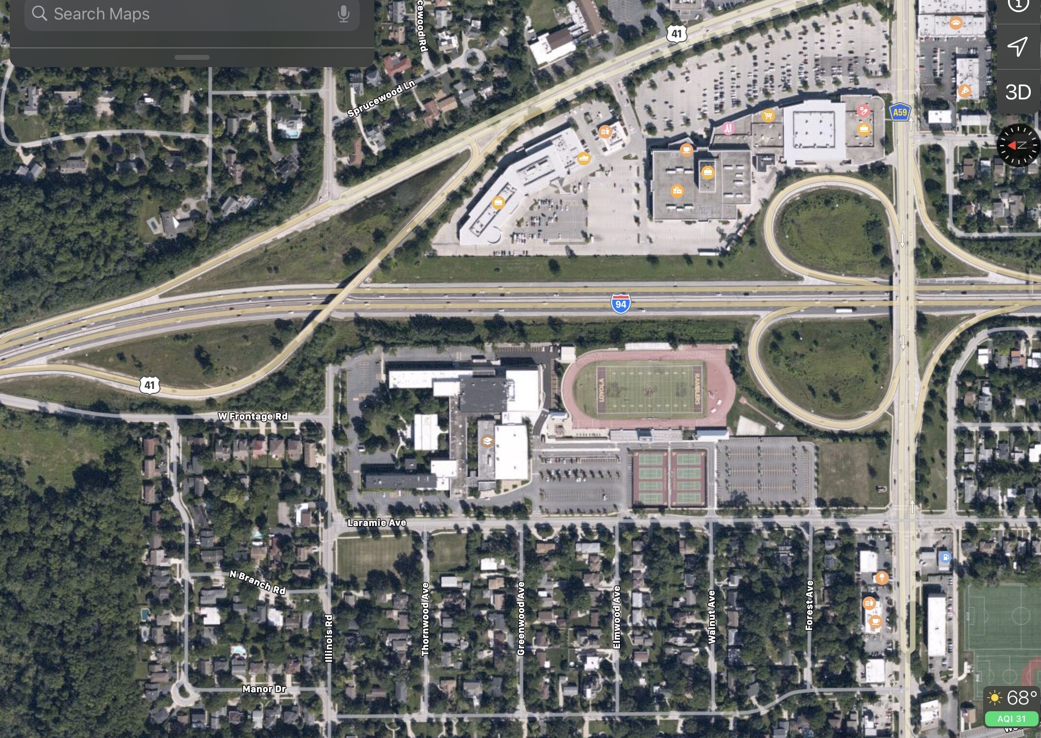
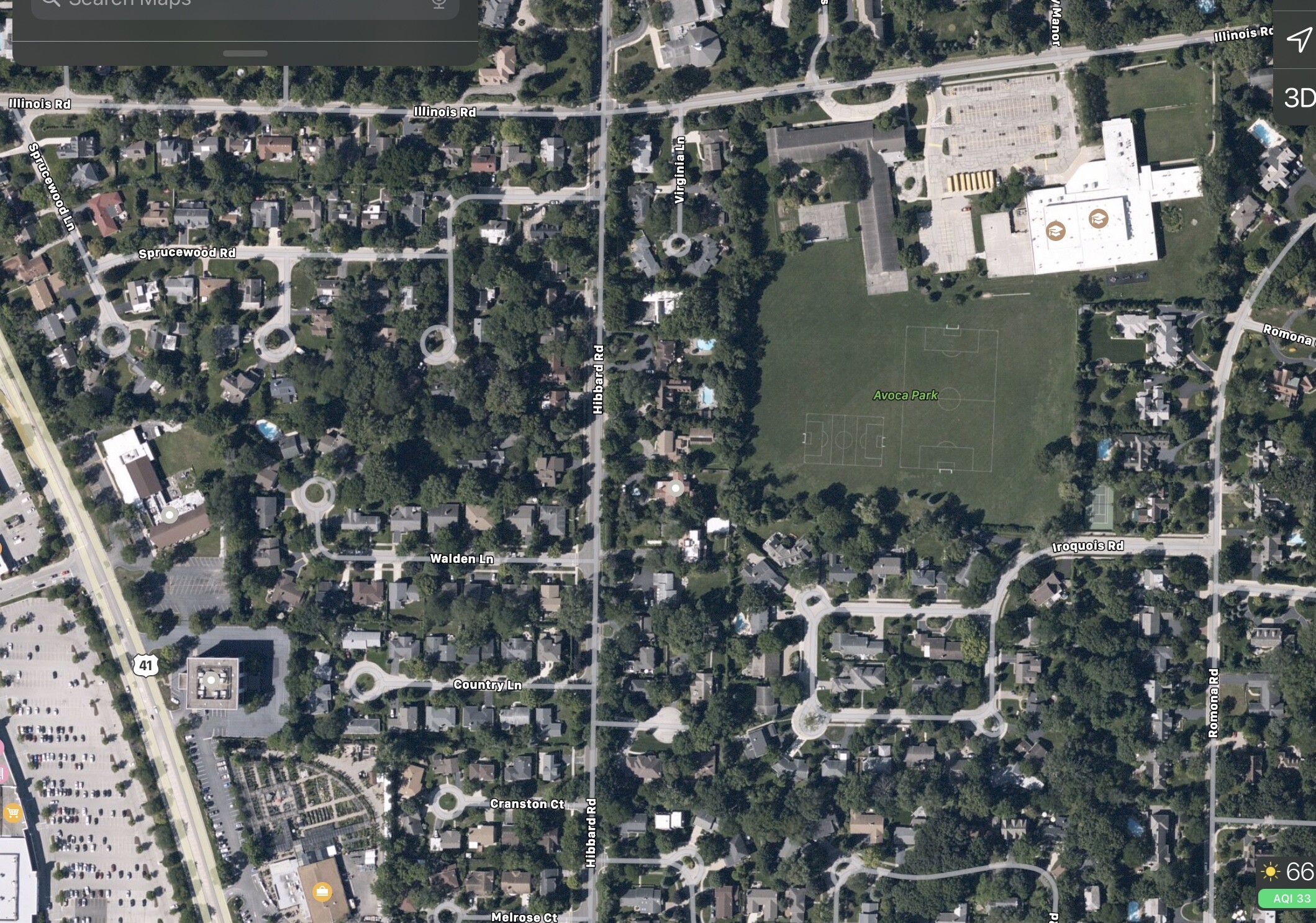
I’ll echo Lisa’s statement. I’m for making some update to this guidance but we should come to some consensus as to when its either not appropriate or is only appropriate. One thing I noticed looking at Apple Maps is they have nearly every school field mapped green. Many of those have lots of trees. Is that the type of Guidance we want? Some go as far as mapping the whole property as green with a few buildings on top of it. I’ll post some example images later. SO in short we should definitely come to a more clear consensus. Also not trying to call you out directly John, someone had to start somewhere, so much thanks for taking the first leap for us
This highlights one of the concerns that several of the Michigan editors had with changing the guidance, that once mapping this category was allowed, that we would get all kinds of crazy stuff if there weren’t specific constraints.
I personally believe that we would be best off to restrict the creation of very large unnamed forest APs for ease of editing. I’m not exactly sure what would be defined as very large without sitting in front of a computer; maybe 100 km²? Something small enough that the entirety of it could be seen at the highest zoom level.
On the opposite end of the spectrum, while I like the idea of smaller APs, obviously there is a size at which they are too small to render in the app effectively. I’m not sure what that number is, but we could consider a minimum recommended size. Perhaps 1000 m²? This seems more objective than trying to count the number of trees.
Joe’s concern makes total sense to me, and it was for the same reason that I did not like mapping national forests. What is green supposed to signify, anyway? I’m not sure there’s a good answer for this, because golf courses and parks are green on the map, so users are already aware of the fact that green does not always equal trees.
i’m in favor of a change with a caveat- instead of just the table saying it’s ok to map there is a section for Natural features added under “Detailed guidance for select categories” in the places wiki. The natural features section can address the concerns of mapping over existing water layers in the app, identify how many trees to map, etc… as others have pointed out editors will read it’s ok to map trees and go forth mapping all the trees. so we need a section that spells out more about how natual features should be mapped.
Agreed. At a bare minimum, there should be a bit of positive guidance before any “don’t”s. For example, for forest/grove, “Use to map any forested area.” For the water types, “Use to map any waterway or body of water that either (1) isn’t on the native water layer or (2) is on the native water layer but (a) would otherwise be covered by another area place (park, forest, large campus, or otherwise) or (b) is so significant that the name should be shown in the app.
But it does deserve its own section, and its own section would be easier to follow.
These aren’t necessarily examples I’m saying we should or shouldn’t map, but something we should at least keep in mind to what others might see and think or want to add. Personally I think it would be nice to see more on the map than we currently have, for example having the green space for fields at a school would be a nice touch, especially for larger high schools that have large amount of field space. Some may have designated names already that should be mapped but others might not.
other things to consider might be, mapping of green areas that aren’t officially named(see green space near highway above). Are we encouraging non named areas to be mapped? Does/should guidance be different in urban and rural areas?
We will never get to the level of detail in Apple Maps but I think here is room for improvement
(unavailable attachment: 0F09FE99-FD56-4B21-BF1B-BE6320B3B28B.png)
Glad you mentioned that actually Joe. A few years ago I added the quads as “parks” on the Tulane and Loyola campuses, and it adds a nice bit of flair to an otherwise gray blob. Might be nice to also add unnamed park areas to, e.g., the fields of open-air sports stadia and the like.
Thank you everyone for the fantastic comments and ideas so far.
Valid point Seth - I have updated my suggestion based on the input that sketch made.
Good point Lisa. Right now I am thinking just saying “forested area” which in my mind is meaning a grouping of many trees But if someone can come up with a way of saying not to map a grouping of only a few trees while still allowing the grouping of a decent amount of trees, please help.
Below are my updated suggestions based on the input so far.
I don’t think that it needs to be limited to just publicly owned lands. Most of these will be unnamed places and not designed for routing. They are primarily for visual affects in the app. I do agree that if the forest or lake is going to be named and added for routing then it should not be a private place.
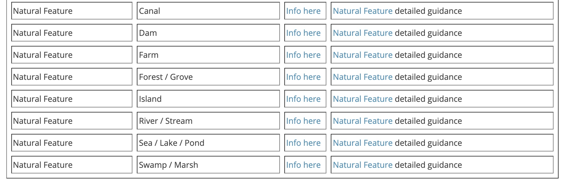
since i proposed adding a page for Natural Features to clarify the mapping of these features i figured i should back it up with something. here is proposal using some of the language from Jm6087 last update and expanding on clarifying how places render in the app. this page would also be referenced in the “Detailed guidance for select categories”
in addition to this page i propose adjusting the area/ point table to the following:
i put “Info here” which would link to the natural features page. this would be an attempt to get editors to understand the complexities of adding these area places instead of just seeing “Area” in the table and blindly moving forward.
well, any land that isn’t on the native land layer addresses the issue because the land isn’t in the app but it should be. it’s better to keep the wiki general instead of adding specifics for everything. there are other specific use cases for the other categories that i can think of that i also didn’t add.
I agree with adding that bullet point. It also helps someone that thinks of an island by the definition of “a piece of land surrounded by water”.
Further down, “When adding any area place such as Forest / Grove, Farm, or Island in WME it could potentially cover up the native water layer which is undesirable.”. I would remove “which is undesirable” because it is desirable in some circumstances (such as an island covering incorrect native water layer).
Under Farm, “Farm should be mapped as a point place. If it is mapped as an area place” sends a mixed message. Is it a point place or an area place or whatever I want to use? It should be a point place. We could possibly change guidance to allow area places for landmark type farms, but really that’s all that should be mapped in the first place. We don’t want places for “Joe’s Farm” and “Ben and Sarah’s Farm” all over the map.
The additional page is a good start. As with any page, it would be nice to add some examples, do/don’t with pictures. :twisted: (you don’t have to, but I think it could be helpful). In general, I think it is nice to call out a new page IF it has significant additional guidance and help. Otherwise, we can just put the text into the boxes in the table and make it easy for people to see them at a glance.