There was a request for an overlay that showed Puerto Rico’s districts
https://greasyfork.org/en/scripts/11810-wme-counties-puerto-rico-districts-census-2014
There was a request for an overlay that showed Puerto Rico’s districts
https://greasyfork.org/en/scripts/11810-wme-counties-puerto-rico-districts-census-2014
Alaska and Texas could be split if the resolution is an issue. the problem with attempting this is the census files are not sorted in a way that would be helpful.
Joining the smaller areas would be more work then it is worth.
I have asked that this not be used in the MapRaid, as it’s adding confusion for a lot of editors.
Is anyone else having an issue where the overlay is duplicated and stuck on the last segments edited?
This tends to happen after using the Awesome Screenshot Chrome extension.
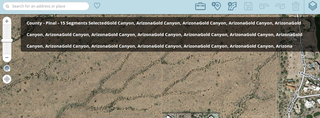
Yes, this is what I posted about in August. I do not have the extension you speak of. It never went away so I stopped using them.
all of the county overlays have been updated to work with the new WME. they all should be version 2.1.
Fredo-P and driving79 this update made changes to the function that added the area name to wme, as part of the update I removed a few lines of code that might of been causing your issues.
Can’t wait to test it out.
Hi.
So, I am out of Virginia and I noticed that for ex: Williamsburg, its a city, and its showing up as a county. Its only a little bit confusing when looking at city layers v county layers overall, so I do pan back and forth. But its most accurate than the WME drawn color layer due to the sheer amount of smudging. 
Either way, This will be a great asset to me in the near future!
I did not attempt to validate any of the county information it is a direct conversion from the US 2014 census. I just checked and 2014 is still the most recent file posted. Changing the name would be easy, but count shape would remain the same.
i just updated all of my overlay-ish scripts to remove unsafeWindow, if there is any issues let me know.
Just a suggestion, but it would be easier to read if formatted as “X County - City, State” rather than “County - X - City, State”.
I made the change myself in my own copies of the script –

(Also, the Louisiana one should say X Parish rather than X County.)
Ah. Okay. Its not a big thing, its just a bit confusing when I do not have my city color layer on and I am on “smudge patrol” as I call it. Thanks though!
I like keeping this script on and seeing the county borders as I move around PA. But I noticed that the city name doesn’t update as I move around. I could be in Pittsburgh, and the bar will read “County - Allegheny - Pittsburgh, PA” and then if I move to Philadelphia, the bar reads “County - Philadelphia - Pittsburgh, PA”. I can scroll all over the map and the county name updates but the city will still read Pittsburgh until I refresh my browser tab.
If you replace the CurrentRaidLocation function with the below CurrentRaidLocation function it should fix this issue.
[code]function CurrentRaidLocation(raid_mapLayer){
var mro_Map = Waze.map;
for(i=0;i<raid_mapLayer.features.length;i++){
    var raidMapCenter = mro_Map.getCenter();
    var raidCenterPoint = new OpenLayers.Geometry.Point(raidMapCenter.lon,raidMapCenter.lat);
    var raidCenterCheck = raid_mapLayer.features[i].geometry.components[0].containsPoint(raidCenterPoint);
	var holes = raid_mapLayer.features[i].attributes.holes;

    if(raidCenterCheck === true){
       var $span2 = $('#state-county');

       if($span2.length === 0)
       {
           $span2 = $('<span>', {id:'state-county'});
           $span2.text('County - ' + raid_mapLayer.features[i].attributes.number + ' - ');
           $('.location-info').prepend($span2);
       }
       else
       {
           $span2.text('County - ' + raid_mapLayer.features[i].attributes.number + ' - ');
       }

        if (holes === "false") { break; }
   }
}
}[/code]
*Note - I have only tested this on the Ohio Counties overlay script
Thank you, Justin, that does seem to be working in PA now. As I scroll around the map, all the info updates.
Thanks for the fix. They work for me now
Not sure when this happened, but this overlay script now depends on the WME Map Editor - Validator Fix scrip to work.
Appears the overlays are not working under the /en-US/editor URL’s. I can switch back to English from US English and it works again.
Tried to change the @include to the regex version, but did not work.
I run in en-US and they are working fine for me
It works for me under US English only if I also have the “WME Map Editor - Validator Fix” script running.