Dealing with Road Closure Requests (MP)

Road Closure Requests are a new type of Map Problem that are automatically imported into the editor from Elgin. Here’s what you should do with them…

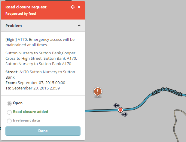
A170.png

First, attempt to verify if they are valid, and maybe get some more accurate details about the location, direction and duration. The reports from Elgin (also Roadworks.org.uk) are mostly spot on, although often claim the closure is for an entire day rather than just working hours.

If the closure request is bogus, for example on a cul-de-sac, non-drivable road or lane closure, then mark it as Irrelevant data. This feedback will be passed back to the feed provider so they can improve their information.

If you have necessary permissions to set closures on the relevant segments, then go ahead and set the closure. If you don’t have permissions, then you can pass the request up to a higher editor to implement for you, as per this thread. Remember to include all the information needed to set the closure.

Further tips:

  • The UR/MP Tracker extension can show you all the closure requests in your area.
  • If the segment needs splitting, and the closure starts more than a week in the future, you can probably get away with it as long as you remember to come back after the map has updated.
    Otherwise, you’ll have to figure out which segments are best to close.
  • Daytime or overnight closures that repeat over several days are easier to apply via the Closures sheet.

Addendum: Requests from TrafficMaster will no longer appear in WME.

If the segment needs splitting?

Like if the bridge is closed, but the segment is much longer and between two junctions. Sometimes it’s necessary to chop the segment into 3: one for the bridge (higher elevation while you’re there) plus one either side. Segments get new IDs when you split them, so you won’t be able to apply a closure until the Livemap is updated again.

If there isn’t time for the map to be updated before the closure is needed, then you’ll just have close the whole segment.

A couple of weeks ago, we had a major batch of these closure MPs appear. I did practically nothing else last week and have probably dealt with about 700 closure MPs over the last 2 weeks. So I’ll share a few thoughts from my experience.

Small closures in long segments. Often these closures are at bridges/underpasses. As said above, if the closure isn’t for a few days, you have a chance to split the segment and set the correct elevations. Whilst you’re at it, I would advise doing the same for any other bridges you see nearby. Rail bridges, in particular, often have maintenance work or scheduled inspections. If you split them now, it will be much easier next time there’s a closure. Plus, it drives me crazy when I see a 1 mile segment at elevation -1 because 30 yards of it goes under a dual carriageway! :twisted:

If a closure in a long segment isn’t at a bridge, it may not be worth splitting it. Another editor may come along later and remove the split anyway. Most of these tend to be in rural areas anyway. Consider who you’re implementing a closure for: is it a very small number of local visitors, or for people who would otherwise be routing through here on the way elsewhere? If there are few destinations on the long segment, perhaps you can just close the whole thing?

Roadworks.org is Elgin: every closure MP will have details from roadworks.org. But to find them, you may need to select a few extra things from their layers menu:

  • Live Incidents: Road closures
  • Road closures & diversions: Road closure, Diversion route (helps you visualise what’s going on), Bridge closure
  • Traffic restrictions: Road closure crossing
  • Public events: All of them. Many of these closure MPs are for special events
    Don’t forget to view roadworks for, at least, the next 2 weeks. It defaults to “today” and keeps changing back to that! Often, the detail popups for the icons will have links to useful documents like Traffic Restriction Orders. Sometimes the closure icon won’t have details, but there will be an associated roadworks icon that does.

Cul-de-sacs. I need to slightly disagree with Tim. :shock: You don’t necessarily have to add these closures - their effect on Waze routing is truly minimal. But I wouldn’t mark them as irrelevant - if they are correct, why effectively “mark down” the data supplier?

Hertfordshire CC have a really bad habit. They publish a load of closures along the lines of “Closed for 2 days within this 20 day period from micro-surfacing”. What can you do? Mark them as irrelevant and move on. :frowning:

Duplicate MPs. Some of the big batch of closures were duplicated. Whether that will be an ongoing thing I don’t know, but keep an eye out for second closure MPs directly under the first one.

Times The MPs almost all state a time of 00:00 to 23:59. I’m sure that’s because the closure times are not included as an available part of the structured data. Even if roadworks.org has the times, they are often in the text description. Generally speaking, I start closures at 6am (assuming they may close the road an hour or two before starting work) and end closures at 8pm (allowing time for finishing a bit late). If a closure is Monday to Monday, I sometimes assume that, because it apparently includes weekend working, the closure is aimed to finish in time for Monday morning traffic - particularly if it’s a major road. In those cases, I set an end time of 6am Monday. These are all guesses - feel free to make your own. :smiley:

Are some Elgin road closure now being added automatically?

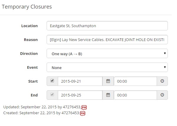
I was just looking at this request in Eastgate Street, Southampton and then realised that the closure is already there, apparently without an real editor approving?

closure.jpg

This has not been added directly - try refreshing your browser and you’ll see who added it - with several errors:

  • Start & end times set to 0:00 - it’s very unlikely they will start & finish work at midnight. I would set 7am-7pm (since the nights are starting to draw in)
  • End time set to 00:00 on the last date listed by Elgin - so guaranteed not to be closed at all for the last day of working.
  • Entire Elgin description copied into closure - useless for the app. “Cabling works” would be appropriate.
  • MP not closed.
    Advice for closures is in the post previous to yours. :slight_smile:

Whilst we are thinking about dear old road closures, can an easier way be found to add these?

For example :-

If we have a closure that is going to be ongoing for 2 weeks, Monday to Friday 8am till 6pm, this entails an editor doing 14 separate edits.

Can this no be more like restrictions where we select the times and days?

This would make life easier and reduce the chance of errors.

M

Bump: There are around 500 Map Problems in the Editor right now - if anyone can pitch in and help, I’m sure Iain would appreciated it. :lol:

Some quick tips to help you get through them:

  • If you have your own custom areas, you can enable the “Hide all but <x>” filter to do those first.
  • Enable the ‘Hide visited’ filter, and wizz through the list looking at the start dates.
    Concentrate on the ones starting soon, leaving the rest for another time.
  • Any closure on an unnamed street with no GPS tracks can usually be ignored,
    as any closure is unlikely to affect any users.

I’d like to suggest we take a bit more care with closures.

One of the reasons they take some time to get through (for me at least) is that I invariably find mistakes in the area or even on the roads I’m closing: missing names missing roads, badly-aligned junctions. If you think it’s worth closing a road to provide a benefit to Waze users, then isn’t it worth correcting the obvious mistakes that will benefit them for far longer than the week or two the road might be closed?

Of course, you have to be careful with any corrections you make before adding a closure, in case you split or delete a segment that you need to close. I’ve caught myself out several times this way.

I have a rapidly-growing list of places I’ve bookmarked that need more work. If I ever get through this latest batch of closures there will be quite a few places where routing will be improved.

Also, if you decide to split a segment (say at a bridge) ready for a closure that’s some distance in the future, please drop a [NOTE] UR there to say what you’ve done. It’s quite irritating to enter a closure only to find that, when you hit save, WME can’t find the segment to close. :lol:

Done a handful around Watford in my lunch break. Having not spent much time dealing with closure MPs before, I’m finding the UI is as much of an impediment to completing each one as the somewhat patchy quality of the data imported into Waze from Elgin - who thought having the closure editing window opening on top of the MP details window, obscuring all of the details you need to know in order to fill out the closure, was a good idea?

And regarding the comments already made about how these MPs generally list the closures as running between 00:00 and 23:59, the ones I’ve just dealt with all had more accurate timings listed in the “Closure in force” field on roadworks.org, so it’s a shame that information isn’t being included as part of the Waze feed from Elgin where available…

We’re all aware of the problems with authorising closure areas, since Waze will not accept an AM area, only a permalink. Whinging about it here won’t help. I’d rather hear from editors who do want to help than those who aren’t going to.

In the meantime, as a reminder to all editors please make sure you have the live users layer active and you are visible when you are working on closures. That way other editors won’t waste time working on a closure, only to get a save error because someone else has duplicated the effort. :evil:

Just in case someone else is unaware of what this means, you need both “live users” checked in the layers drop-down and “visible” in the chat room box (although you don’t need to have the chat room box open).

How to close a level crossing without splitting the segment

  1. shrink the existing segment down to just a few metres
  2. connect segment to railway to form a junction
  3. draw new segments either side and add original name, turns, etc
  4. close 1st segment, which will work before and after map update

If the closure starts before the map updates, then the whole road will be closed as before. After the map update, just the small section will be closed. Also works for bridges and other roads that need it, as long as you don’t change the segment ID.

The alternative approach for a level crossing that does already have a junction node is to put in one-way closures either side, in the direction away from the junction. That way, drivers will be navigated to addresses near to the crossing but not across it. (Hat tip Dave2084)

I’m not quite following this, doesn’t step 2 immediately blow away the original segment ID we’re trying to preserve here?

No, it doesn’t. Only splitting or merging segments will change the segment ID. Other edit operations do not affect it.

Yeah, that was the mistake I’d made earlier - I was thinking that the shortened segment from step 1 would still be crossing the railway segment and therefore step 2 would require the splitting of both the rail and road segments to form a crossroads.

Whereas, if I’ve now got things clear in my head, step 1 shortens the original segment to form a stubby t-junction with the railway, and then one of the new segments drawn in step 3 completes the “crossing” of the railway. The resultant closure then doesn’t straddle the railway (which is also what I was, too literally, visualising as the required end result of the whole process) but has the same desired effect on routing.

Like this…

…however hard I try WME just won’t let me enter the 39th of November :lol:

The UR-MP Tracking script has been updated. It should be more robust during scans, and now supports road closure requests. Sort by date is very handy (but careful about clashing with other editors following same order).

Sent from my Nexus 4 using Tapatalk

I seem to have been doing little else but closures for weeks now. UR-MP stats tell me there are currently 629 closed MPs in the UK, of which I’ve closed 507. I’ve probably done 1500-2000 closure MPs in the last month or two. As I continue to get more experience of these closures, I thought it’s time to share some more knowledge. :geek:

Most importantly, many closures that appear to run continuously for a number of days do not, in fact, do so. Some are overnight only, or off-peak daytime only. I have to say that for most closures, it is necessary to check the details on roadworks.org, rather than taking the details in the MP at face value.

  • The A and B points are fine if it’s a simple road that’s closed. If you have, say, an area of roads closed for an event, the position of A and B may be pretty meaningless. Check the red closure lines on roadworks.org if there is any doubt.
  • The MP marker is always mid-way between the A & B points. If you find an MP in the middle of a field, it might be for the closure of 20 miles of B road!
  • Closures to major roads or long segments are often not 24/7. The bigger a road, the more likely it will be overnight or off-peak closures.
  • “Carriageway patching” mean pretty much what it says - fixing patches of road surface. This is often done during off-peak daylight hours, leaving the road open for rush hours, overnight and weekends
  • Resurfacing can be done in sections allowing traffic through in between times. Again, major roads may have resurfacing like this. Rural roads, or roads where there is an easy diversion route are more likely to close 24/7
  • “Micro-surfacing” is still re-surfacing. It just means skimming off & re-laying the top layer of tarmac. It’s cheaper, but still closes the road
  • Most utility works (gas main, water main, sewer, telecoms duct etc) involve digging up the road. These will generally be 24/7 closures…
  • …unless the details say “working in the footway/verge”. In that case, the closure is for the safety of men & equipment and the road may be open outside the working hours
  • “Communication pipe” is nothing to do with BT! It seems to be a term referring to the pipes that come off of a water main/sewer/gas main etc going towards properties. So a “burst communication pipe” does not mean someone tried to download too much porn. :lol:
  • Please keep the description brief & meaningful. You don’t need to copy in the whole MP text.
  • Level crossing closures are almost always overnight at a weekend
  • Related to that, closures may not run from the start date to the end date continuously. If you see a level crossing closure for 3 weeks, for example, often the actual closures are for the Saturday night during those 3 weeks only

Lastly, and most importantly, if you are not sure about a closure MP please leave it! I’m fine with closing the MPs for closures on dead-end segments - adding the closure will make no difference to routing. But if you find a closure in the middle of nowhere and you don’t feel it’s worth actioning, just leave it. I will get to it sooner or later and do it. Some MPs get re-posted 2 or 3 times and I’ve found MPs re-appear for some major road closures that were never actioned, right next to closed MPs.

Of course, if you’ve really searched and you cannot find enough details to action a closure, then close the MP. I’ve done over 100 closures for Remembrance Day Parades. Some councils give great info. Cheshire, on the other hand, give no closure times at all. Some of their closures I’ve managed to do by finding details on local websites, but some I’ve just had to close unsolved because I just can’t find the details.

If you are doing closures in Devon, please be aware: they are posting a lot of closures for a long period. When you check the details on Roadworks.org (you are checking, aren’t you? :wink: ), there will be an attached PDF with more likely dates covering a much shorter period.

For example, closure has dates 12th-25th April. PDF says the closure is 12th-16th, which is much more likely for the length of road being resurfaced.