There is a main thoroughfare near my hose that closed yesterday in both directions for the next 13+ months for construction. I tried to enter it on Waze Map Editor and gave up after 30 minutes. While the app looks simple, it is difficult to use.
Hi,
You normally have to be an experienced editor to add closures.
Can you tell us the city/state/country you are referring to and the road that is to be closed with the start and stop intersections of the closure. Also will any cross traffic be allowed at intersections? This will help us get it into the app. Thanks.
Road Closure (both directions) no cross traffic allowed on Bradley between the concrete closure barriers - from August 4, 2025 to September, 2026 (13+ months) to allow the construction of a bridge across a creek bed that overflows during the rainy season.
City Project Link
https://www.cityofmenifee.us/1070/Bradley-Bridge-over-Salt-Creek-Project
Bradley Rd. in Menifee, CA 92586
North end of closure is just south of Pebble Beach Drive (see attachment for barrier placement)
South end of closure is just south of Rio Vista Drive (see attachment for barrier placement)
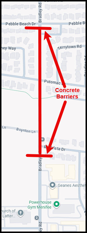
Thank you.
I’ve put in a closure through the end of October 2026.
Please let us know if the closure ends before or extends beyond October 30, 2026.
The Bradley Road closure is set to reopen tomorrow, October 1, by 5 PM based upon reports from the Menifee City Council.
Thank you. I’ve set the closure to end at 5 pm, Oct 1.