Heathrow Airport (Public) Private Roads

Sorry this is a bit long but here goes anyway :shock:

There are many roads around Heathrow that are mapped in Waze as public but are in fact private and should only be used if accessing the airport, not as short cuts or for traffic avoidance.

All roads inside and including the Perimeter roads are private (on the north side of the airport all roads south of the A4 should be included) and should not be used for general routing. If you don’t know Heathrow this may not sound controversial but we have these roads mapped as primary streets, one of them is a dual carriageway!
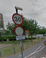
except for access.PNG
At each entrance to these roads is a sign with a red circle on a white background usually with Access Only posted below along with a copy of Heathrow Bylaws. However as we haven’t marked any of these roads as private Waze will happily use them for shortcuts or to avoid traffic.

Some examples:

  1. There are several UR’s on the A4 just north of the airport where Wazers travelling east have been directed just into the airport to join the M4 Heathrow spur and hence up to the M4.

  2. I was stuck in the usual M25 northbound queue last week when Waze suggested exiting at J14 following the M25 link into Terminal 5 then routing around the western and northern perimeter roads and onto the M4 spur. This then routed up dual carriageway and eventually onto the A40 / M40. Fantastic short cut bypassing all the M25 traffic but not legal!

  3. Traffic from the south east side of the airport can be directed by Waze to use the perimeter roads if heading north or west rather than using the A30 / A312 / A4.

Therefore I propose that all entrances to the airport should be properly set as private roads (where they pass an access only sign) but should the roads also be demoted from Primary street to just a street? I’m assuming the best way to do this is to just set a short one way only private road so that routing in is prevented but not routing out of the airport.

In addition there is an authorised vehicles only sign where Wright Way joins the Northern Perimeter Road. Presumably this is to stop traffic from T5 exiting the airport by any route other than the M25 link road.
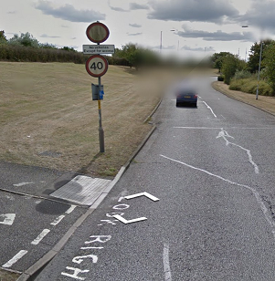
except for access A30 slip road.PNGexcept for access A3044.PNG

Andy.

It sounds to me like the entire perimeter road plus inner roads should be marked as Private Roads.
This is the usual guideline for these kinds of access-only areas.

Is there a particular reason or benefit to having the perimeter as a Primary Road? What would be the downsides of having it as a Private Road? I don’t believe that routing would be affected this close to a departure/destination.

Adding Private roads to the entrances and exits is a possible solution, which I’ve used on a small village that was access only. Getting it right for Heathrow could be tricky, and one mistake could unbalance routing for the entire place.

Any sections of road that are restricted to authorised vehicles only, then Restrictions can be added to prevent routing any drivers that way.

Sounds ok to me, certainly having all the roads as private will be easier than only marking entrances as private. If the private status on one entrance was accidentally deleted it would completely mess up routing although locking at lvl 5 should protect against this.

If we do make all the roads private it should ease my second proposal which is to delete all the airside roads which can mess up navigation. Airside roads are all those only accessible having passed through security and can only be driven on by someone holding a CAA approved driving licence. There are many at Heathrow (and Gatwick) which are often closer to a destination than publicly accessible roads and there are currently several UR’s around Heathrow due to airside roads. Therefore I suggest we nuke all airside roads and lock the entrances at Lvl 5.

Sent from my iPhone using Tapatalk

Sounds good to me, I’ve never understood why airside roads are on the map in the first place - but I’ve lacked the courage to stick my neck out and delete them.

While you’re there, there’s a bit too much detail with all those green landmarks…

I’ll nuke the Heathrow ones and leave Gatwick to you. I work airside occasionally, mainly at Gatwick and the airside roads in Waze are useless. Depending on the drivers license we either have to stick to airside roads around the periphery or we can drive right across the taxiways and aircraft maneuvering areas. :roll:

Nuked, I can’t believe that someone actually bothered to map all the little bits of grass between taxiways and runways. Mind you he was a foreign editor who probably had hours to kill between flights so I guess he was limited in what he could do with only a three mile raduis of T3. :lol:

Gatwick private roads nuked. Except for part of the Southern Perimeter Road which leads to large car parks.

I’m rather angry that ALL of the green landmarks at Heathrow have been deleted. I spent a good few days restoring these recently after BlackCatYamoto turned them into point places.

It makes the map look better having them on there.

http://i.imgur.com/GT3tTAD.jpg

So can the person who deleted them now put them back please? It’s unnecessary to remove them even if a couple of people think they don’t need to be there.

How about drawing the runways instead? That would give a much clearer overview of the airport, and would look better in the app.

I was going to, it was only a few days ago that I finished restoring the grass.

I really do think it looks better and there’s no benefit to removing it.

I think it’s more than a couple of people who think it’s good they’re gone. I’ve been wanting to get rid of them for a long time as I think areas like these just clutter the map on the app. They don’t affect navigation nor do they help a driver orient themselves i.e. passing a park on the right etc. They are entirely cosmetic and shouldn’t really have place on a map whose only purpose is navigation.

Its only purpose isn’t navigation.

The live map is a map. You can say it’s only for navigation as much as you like but it’s nonsense.

At the end of the day the ‘Park’ area is designed for mapping areas of grass which gives users of the waze app a better idea of their surroundings. It’s not unreasonable to drive just to the right of a patch of grass and to expect to see it on the map!

Look how awesome some other airports look:

Charles De Gaulle
Gatwick
Heathrow

Compared with these empty spaces:
Brussels
JFK
Manchester

They look crap

You also have to bear in mind that not everyone has a modern, fast handset with a large, high resolution screen that renders quickly. A small but significant chunk of the users will be using older devices. My partner has such a device and not that old either which is why it’s an issue for me. These areas of green take a little while to display and look really awful when they do. It is often hard to see the roads. While it’s rendering the green bits the roads aren’t rendering. Whenever we go past Gatwick, which we do a lot, the app virtually stops working. We have to consider the experience for the entire user base, not just the ones with fast handsets.

Then perhaps Waze HQ need to adjust the app. We shouldn’t have to remove landmarks to suit people’s phones. Perhaps a ‘Slow CPU’ mode for those with lower spec handsets?

And if anyone deletes Gatwick’s grass areas which took me several hours to add, I will be exremely unhappy. I’m sure you wouldn’t appreciate it if you had hours of (voluntary) work deleted.

You’re absolutely right. The Waze developers should consider that but I don’t imagine it’ll be along “soon” From my personal experience it’s worst when there are a lot of landmarks close together like these areas at the airports. I’m sorry if I’m being selfish but from my point of view these detract rather than enhance the navigation experience for users with slow handsets and I tend to hear quite a lot how slow Waze was on the drive to Crawley (and why can’t I do anything about it!)

I completely understand that a lot of effort has been put in which is exactly why I haven’t cleared Gatwick even though it irritates me. I would be upset too. I’m just arguing that now Heathrow has been cleared we should think carefully before they are put back.

I like pretty looking maps and it looks quite good on the live map.
My phone has no problem processing the images, however it has a fairly small screen and the result is that Heathrow looks messy on my phone.

Mapping the runways would help with orientation whilst keeping the map clean.

The other problem with mapping the grass is that we have to classify it as a ‘park’, and there is definitely no way that those scetions of grass are park.

I seem to remember the CAs had a discussion about the Heathrow landmarks when we first noticed them. Initial opinion was “nuke 'em all”. But then we agreed that it actually didn’t look bad in the client and it was a shame to throw away all the work someone had done - even if very pointless - and we left them alone.

I am a very big fan of marking landmarks (in the very literal sense of the word) that can be seen from the road. If you’re driving along a road and passing big and obvious landmarks that don’t appear on the map, it breaks the mental connection between where you think you are and where Waze is telling you you are. On the other hand, if you drive past a wood and Waze shows a corresponding landmark passing on the map, this reinforces that mental connection. It may all happen subconciously, but it’s something that has a very real effect on drivers’ confidence in the app.

Landmarks that can not be seen from the road are far less useful. If you look at the map and consciously wonder why there’s a big empty space between some roads, a mapped park may satisfy your curiosity. But, unless it’s a landmark that may actually be navigated to, it provides little benefit.

I doubt very much that data or processing will have implications here. Remember that, however complex a segment or area appears in the editor, the geometry gets drastically simplified during the tile build process. Most fine detail simply won’t be transmitted to the app. And if the app isn’t up to showing a few landmarks around Heathrow, it ought to fall over & die in Central London.

Another consideration is the amount of time spend creating landmarks like this. It is almost entirely wasted. However, who are we to dictate how somebody should spend their time editing the map? Yes, I’d rather editors spent their time on more useful work, but they aren’t employees. You probably won’t get made an AM if 90% of your edits are places, but you’re not going to get blocked either. In this specific case, the effort on the Heathrow landmarks may be entirely wasted, as we are still waiting for HQ to restore places edited by BlackCatYamoto. Edits made in the interim may be over-written - or they may end up having taken time to do what the rollback would have done anyway.

Finally, there’s the matter of good manners. If someone has taken the time & effort to do something, even if you think it’s quite pointless, you ought to have some concrete reasons and general agreement to undo that work. And, of course, you shouldn’t do it without giving them a chance to respond.

Well said. I appreciate it’s not necessary to add them but they do look nice.

I was rather upset to come to this thread and see that someone has deleted the several hours’ work I put in at restoring those landmarks at Heathrow.

The Landmarks Wiki does mention the points Iain makes - maybe the upcoming UK Places Wiki needs to make the points a bit more strongly to avoid people spending hours mapping loads of detail that the client won’t show or help people navigate to where they want to be.