My Level: 3
Reason for request:
sign matching: would it be better to have
“to I-80 / I-5 / SR-99 / San Francisco / Reading” (US-50 W is nowhere on the sign)
“to US-50 E / Placeville / S Lake Tahoe” Permalink
Perhaps we should use the 2nd last sign, which is only very short ways from the “very last sign” (you can argue that the “very last sign” really the first sign after the fork too).
“Exit 298A: to I-80 W / San Francisco / I-5 / SR-99 / US-50 E / S Lake Tahoe”
I don’t know, that sign is just as big of a mess. It’s like I want to put an “and” before US-50 to separate it!
My attempt to organize the sign: (to (I-80 W / San Francisco) / I-5 / SR-99) / (US-50 E / S Lake Tahoe))
I thought that entire shield abbreviates into “I-80 BUS”? (This is my first time actually encountering a business loop in Waze.)
I took care of the add-on “since we’re in the area” requests.
Of late I have become less enthusiastic about monolithic wayfinders. A user has reported that when the name gets too long, he tends to remember only the last part of it, and as a result can make incorrect lane decisions.
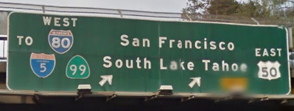
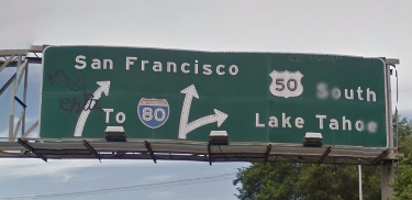
The penultimate BGS looks like this:
The final BGS looks like this:
The instructions as currently configured will be EITHER
Stay to the right to US-50 E / Placerville/ S Lake Tahoe
OR
Stay to the right to I-80 W / I-5 / SR-99 N / San Francisco / Redding
My take is that using these inherited names is better than parroting the monolithic BGS.
The only struggle I have is that the inherited names have detail (Placerville and Redding) that are not on the original BGS. One R6 I respect has suggested to me that names inherited from later turns should hardly ever say things that are not on the signs present at the earlier, inherited turn. If we follow that advice here, we would remove the Placerville and Redding control cities from the later fork.
If we did that, the instructions would be EITHER
Stay to the right to US-50 E / S Lake Tahoe
OR
Stay to the right to I-80 W / I-5 / SR-99 N / San Francisco
I think this last option draws the healthiest balance between matching the signs at the two forks without getting excessively wordy or risking driver confusion.
So my tentative approach here would be to leave things as they are except to remove the Placerville and Redding control cities from the later fork. But I’m open to alternatives.
My personal philosophy is to follow where the sign is “cut”. If it’s cut (either separate signs for one set of lanes, or drawn in lines on the physical sign), the sign actually gives more information (lane guidance), and that our guidance should match accordingly. Essentially, if the monolithic sign is visually divided, then guidance should also be aurally separated.
In this specific situation, staring at this, I think my question is more, “Is the ultimate sign that you described the ultimate sign of the first fork, or is it the penultimate sign to subsequent ramp-ramp split?”
I think I am leaning now for your penultimate sign to be the ultimate sign, as you cannot really see your ultimate sign until milliseconds before the fork; even in SV, it can’t be seen until you clear the 5th Ave bridge. In fact, the inner lanes’ solid white anti-dbag-queuejumper line starts well beyond any guidance from your ultimate sign. In this case, I don’t think there is a big problem with later instructions either, as there is almost 800m before the next split. TTS commands end before you exit, so I think it’s best to follow what one can see as it’s being read out. Separately, this also matches the advance sign here, 1 mi away.
My vote is for monolithic still, but for different reasons (the other sign can’t be seen!). My final vote:
“Exit 298A: to I-80 W / I-5 / SR-99 / San Francisco / US-50 E / S Lake Tahoe”
(the “to” is also kept, as does not directly lead to any of the routes per-se), and then subsequently,
Stay to the right to US-50 E / Placerville/ S Lake Tahoe
OR
Stay to the left to I-80 W / I-5 / SR-99 N / San Francisco / Redding
Where did “Exit 298A” come from? The originating freeway is SR-99 and the right fork is for SR-99, so I don’t believe technically it is an exit. The two BGS do not label it as an Exit, and they’re usually pretty good about that. Granted I could have missed one of those little exit signs someplace. I’m not saying it ain’t so, just wondering where that info is – and whether including it could confuse drivers rather than help them.
The “Exit 298A” question aside, I agree with this approach in principle. My problem here is that the guidance is just so dang long! It takes Jane just under 10 s to read the whole thing once, and Waze will read this essay to the driver possibly three times.
Our ultimate goal is to make sure the driver takes the correct exit with confidence. Copying the sign as faithfully as possible is usually the best way to accomplish that goal, but I don’t believe it is always the best way. Is this case an exception to the rule? I would lean that way.
My personal experience as a driver is that, when Waze has been talking for more than a few seconds, and I already figured out what sign it is referring to, I become increasingly annoyed, not increasingly confident. I have no idea what the average Wazer thinks of course.
One thing we agree about, and that’s that there should be plenty of time after the sign to get instructions for the next fork. So the question here is mostly about the sheer length of the guidance, and only minimally about prepping drivers for their next maneuver.
Otherwise, I’m willing to use your solution as well. You can kind-of chop the sign in half with the grouped shields. This sign ranks pretty highly on “most congested signs in California”.
I have looked at both suggestions and they each have pros and cons. For the longest time, I have been like Nagamasa, thinking that routing guidance should match the BGS exactly or as close as possible. However most recently, I have been gradually moving over to the “inherited name” of the guidance debate. Therefore, in this case I am leaning towards the Dwarflord suggestions. I really would like to get Tonestertm guidance after his pondering.
If one stays left at the junction we’re discussing, one is following signs to I-80 BUS E, NOT signs to SR-99. But lo! Caltrans has signed SR-99 Exit 298B to Broadway a half-km later.
Caltrans is basically saying SR-99 stays to the left, but then dies in a local exit in a half-km. So if you actually want to remain on SR-99 for more than half a km, you must of course exit from SR-99 at “Exit 298A” and find your way to the I-5 shared alignment. During which time you are apparently not on SR-99 but in some kind of inter-99 Caltrans limbo.
Our ultimate goal, as I’ve said before, is to help drivers take the correct exit with confidence. But there is nothing I can see about following Caltrans’ specifications literally that would inspire confidence here. Yikes. I am terrifically reluctant to tell drivers they must take official Caltrans Exit 298A from SR-99 so that they may continue on SR-99…even if that is technically correct.
I’m going ahead with the plan I outlined and that citeman supported, viewing this as an interim solution in the absence of additional review.
 and actually commit to a name: it’s supposed to be I-80 BUS and unsigned I-305. I have a feeling these signs actually pre-date the re-alignment of I-5: