mods sticky this pls
an update on what bangus236 posted
A question to the map editors for the Philippines, keep the road maps simple or follow dedicated turn lanes? The reason I am asking is that adding dedicated turn lanes (usually right turn) adds additional junctions to the road. An example would be the intersection of Julia Vargas and Meralco Avenue here https://world.waze.com/editor/?lon=121.06372&lat=14.58422&zoom=6&layers=BFTFTTTFTTFTTTTTTTTTFT
and the intersection of Julia Vargas and San Miguel/ADB Avenue here https://world.waze.com/editor/?lon=121.05991&lat=14.58439&zoom=6&layers=BFTFTTTFTTFTTTTTTTTTFT
I’m for the simple approach or the first example, how about the other editors?
hey kaz…
what does additional junctions do?
most editors would add those turn lanes for sure.
they add a time penalty for every junction. not only that, it clutters the road and makes maintenance a bit harder.
the time penalty is used to determine which street is faster for a given route, a street with a lot of junctions will be slower compared to a street with no junctions. this may be due to incoming traffic from those junctions merging into the street. the turn lanes will add to the time penalty and i don’t see any value it adds to routing except that it follows the real road geometry
Hi guys,
I was driving this afternoon and Waze wanted me to make an illegal U-Turn along Ayala Ave.
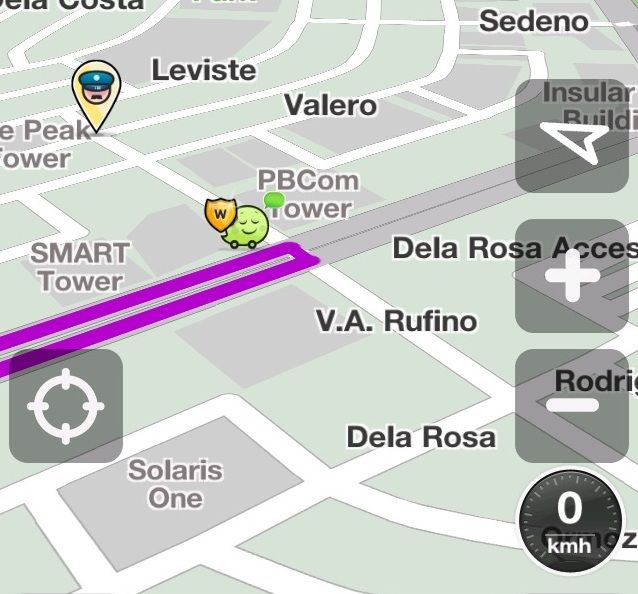
Tonight I checked hoping to fix this but everything seems fine, no Left Turn allowed (so no U-Turn, too):
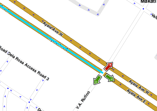
Can anyone check to see what’s up? Thanks.
I’ve already edited this error, although the fix might not be available on the live maps until the next map tile update.
fellow wazers & map editors,
please give extra care on labeling the CITY of your edits.
unlike STREET names which reflects edits (or corrections) made quicker and appears on the next update, CITY names unfortunately embeds much muuuuuch MUUUCH longer on the CITY tiles in the servers.
so misspelled CITY names reflected during an update WILL… will appear for a long loooong LONG time in the client (waze) despite any corrections made.
this i learned from experience.
kindly stick to the OFFICIAL (but shortest possible) NAME of the jurisdiction being edited.
also, if you are UNSURE of the POLITICAL BOUNDARIES of the “CITY” you are editing, leave it at that for the moment. let’s leave it to the more experienced & knowledgeable editors to sort this mater out.
pasalamat na rin at walang barangay level labeling as this would be a nightmare c",)
in the case of “San Fernando” (undetermined if Pampanga or La Union),
our client will reflect the cities of San Fernando Pampanga & San Fernando La Union to be one contiguous city.
i believe this was caused when “MacArthur Hwy” was labelled as “San Fernando” months & mooonths ago.
this inadvertently labelled the city well into the rest of PAMPANGA, TARLAC, PANGASINAN & LA UNION.
though this labeling of “MacArthur Hwy” has been rectified, the City Tiles have not.
and the label “San Fernando” persists to appear again & again despite several Tile Updates.
until such time that the servers detect this area anomaly, “San Fernando” will appear next to Towns & Cities between Pampanga & La Union.
so do exercise caution when labeling your “CITY”
another matter of CITY labels, we omit the “city” to derive the shortest possible official political name of the area.
only with the exceptions of QUEZON, CEBU, DAVAO, CAVITE, etc as these cities have a provincial counterpart.
this will distinguish Quezon City with the province of Quezon, Cebu City with the province of Cebu, so on & so forth.
all other cities (& municipalities) will stand on its own without the label “City” or “Municipality”, provided it does not have a same Province name.
Quick confirm, does it only take one wrongly-labelled segment to make a new-wrong city tile? And do we have to look for this errant segment to correct it? >_<
That is correct. you’ve got it… unfortunately, as mentioned before, once this error makes its way to the updates, it sticks there indefinitely despite the segment being rectified.
Is not it better to follow real road geometry?
Navigation then produces better guidance for driving, which I guess is the main point of waze?
I do not think, we should bastardize maps, just because current version of software, does not do the right thing.
Long term it is easier to fix software to do the right thing, than later on fixing maps.
If you look at Manila and it’s city layers, there are only a few errors with regards to city names. I have been painstakingly looking for those errant segments and so far so good. only a few more around the outskirts and boundaries. time to broaden my search to nearby cities and municipalities
there are times where following the road geometry isn’t really a good thing, these are when the road is complicated and to draw each and every segment on the map further complicates things and causes routing errors.
I agree, that is why if I encounter URs which really isn’t permanent on the map or is an issue with the client, I just mark it as “Not identified” and not do anything