===House Numbers on Service Roads or Frontage Roads===
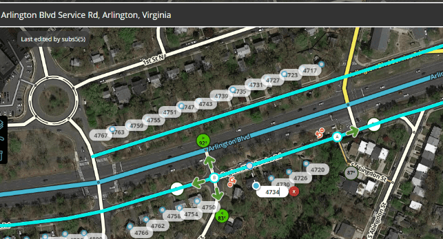
If you have done Update Requests (URs) enough, you probably have received a few on service/frontage roads like:
I can’t get to the address since it is off the service road and there is a barrier.
2.The address is not found since it is listed on the service road, please fix
Arlington Blvd RouteTurn not allowed, I was not able to make the turn from Arlington Blvd to N Montague St. Their recommended route was the PL above. Here you need to make sure that the service road is labeled service road. I originally found it as Arlington Blvd in 2015 and people didn’t see that they had to go to the service road and would turn on the main road and couldn’t make the subsequent turn.
Solutions
There are a few possible ways to fix this problem.
First, you make a small segment at each entrance to the service road (at least 6 m) and label the primary name '[Main St] Service Rd" where [Main St] is the name of the major road that has the service road. The segment(s) between the entrances are labeled [Main St]. Advantage is each turn in gives the service road name and the HNs are attached to the proper street. User is routed to proper location and has aural (with Jane voice selected) and visual cue to where to go. Disadvantage is there are several extra segments added to the map. This one is NON-PREFERED
Second, you make the service road all called “[Main St] Service Rd” as primary and [Main St] as the alternate name. Advantage is each turn in gives the service road name and the HNs are attached to the proper street and minimizes the number of segments on the map. Disadvantage is you either have to manually enter all the HNs onto the service road and delete all the HNs from the Main Road ‘’‘OR’‘’ you temporarily name the service road [Main St], then edit HNs and move the HNs from the real Main St to the Service Road, then save the HNs. Then change the Service Road’s primary name to “[Main St] Service Rd” and the alternate name to [Main St]
Considerations for Second Method
Make sure that road segments which connect the [Main St] to the Main St Service Rd are either a different named segment or unnamed. Having the alternate name on the Service Rd COULD cause Best Continuation (BC)ORBig Detour Prevention (BDP) triggers with unintended consequences.
I PREFER the second one since has same advantage and easier to move the HNs and less junctions. If properly set up it avoids BC and BDP problems.
Tip of the hat to PesachZ about the BC and BDP warning and correction that SDP is not affected…
Here is a link to a draft wiki page if you want to make some recommended changes.
If you have other examples then please post below.
Feel free to post constructive comments like problems that aren’t yet considered or ways to improve the wording, please feel free to post or PM me. Thanks
To repeat what I posted in GHO on this topic:
Just putting this out there, the second option is my preference of the two as well, the first is prone to several issues caused by multiple segments and additional junctions. It can hurt ETA, and cause false BDP triggering in cases. Caution when using the second style that it may also play into BC and BDP issues since the main and service roads now have a matching name. anywhere they meet directly without a median segment (e.g. a fork into the service road, or a bowtie) you will have BC issues, and depending on road type you may have BDP concerns to watch out for.
street type segments on the service road should not mess up BDP, but they will play into BC at forks, bowties and the like. I had a similar situation in NY but based on the routing and continuity had to keep both sides as MH which created a big mess of BDP and BC.
I think we can all agree the first method is not optimal, and I would be happy to see options if there are others presented to be added as TheLastTaterTot suggests, but options should be vetted here before being added.
Here is an example of here’s my personal trouble spot, I did use the second method in that draft, but was careful with the forks and crossovers for BC and BDP concerns. I didn’t want BDP, it is working as I want now, to my knowledge, but took a couple of tries between HN targeting, BDP and BC to get it working right.
Also to mention I have used the second method in this order in several other locations with success.
The segments for the service originally were named the same as the main road from basemap, if they are not then name them with the same primary name first.
Nudge all the HNs a bit, and save them. This has 2 benefits, it confirms them given them routing priority over 3rd party sources, and if positioned properly over the houses will snap their stop point to the service road.
Rename the service road segments with “… (Service Rd)”, and add the main road name as an alt name.
Check for any Bowties, or forks where the main road connects directly to service road, or a feeder road connects directly to both the main and service roads, and eliminate any Best Continuation issues.
Check and adjust if necessary any slip roads, in most cases these are best left as no-name segments.
What if someone is driving on Margery Dr and get’s an instruction “Turn right on Fremont Blvd”. How do they determine which turn to make without having to look at the screen?
Well if you choose not to look at screen then at any turn a mistake can be made. This question can be applied to any turn if not familiar to area, Waze gives distance and also a turn instruction, since there is space between the 2, if your turn at either Waze will say turn at location. If you pass 1st Fremont then it says turn then must be 2nd Fremont. Correct?
first Fremont After 167.32 feet, turn right
Fremont Blvd
second Fremont After 252.62 feet, turn right
Fremont Blvd