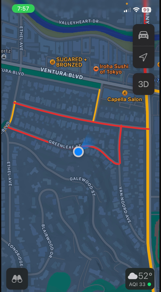
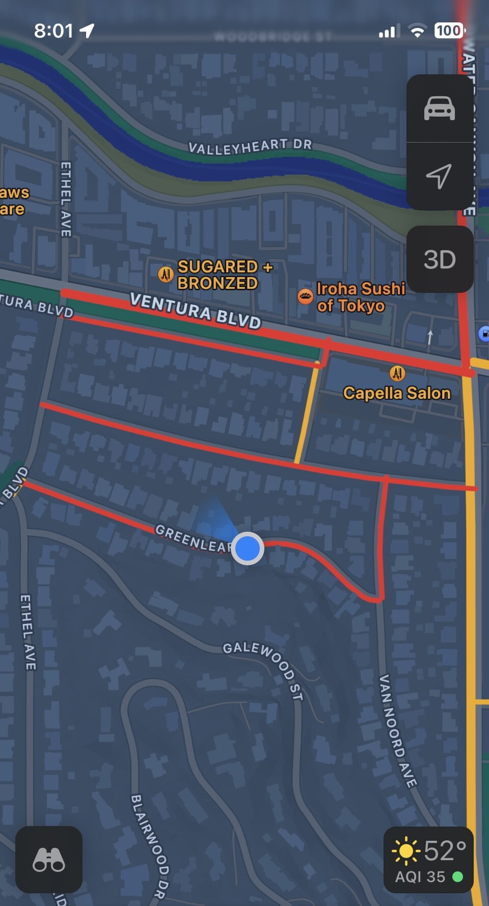
Waze has been directing morning commuter traffic onto my residential block that is restricted with signage that it is not a thoroughfare between 7-10am. We live on Greenleaf Street in Studio City, California 91604 between Valley Vista Blvd and Van Noord Ave.
The street is narrow (with room for one vehicle) and residents cannot get out of their driveways for over an hour in the morning because of the congestion Waze is causing by directing commuters through a restricted residential road. I called a business vehicle that was blocking our driveway for over 7 minutes this morning and they stated that Waze directed them onto our street. I attached a Google maps photo of our street this morning that was so congested that even Google Maps registered the street as red. I also took video of this morning showing how we could not exit our driveway or access our street.
This started and has worsened over the last few weeks and I have spoken to law enforcement and they have been ticketing vehicles in the mornings for using our restricted road.
Please let me know what Waze will do to address misguiding cars onto a restricted road and causing lack of street access for residents?
Waze has the left turn from Valley Vista onto Greenleaf and Dickens restricted (7-10am) to match signs. Waze should not route through that restriction. It should also avoid the street due to the congestion you are reporting.
We’ve received a map update request to Waze support and we’re posting here on the user’s behalf. The link to this post will be forwarded for the user to follow up.
Additional Information - The user stated that Greenleaf street in Studio City CA has a restriction between 7:00 AM to 10:00 AM and non residents shouldn’t be allowed to enter the road during that time.
There are no circumstances by which non-residents should be routed through Greenleaf street during commuting hours. Greenleaf street is a narrow street that does not allow street parking on both sides of the street. When Waze routes non-residents through in the morning, it turns the street into a stop and go bottlenecked street and converts Greenleaf street into a one way street (which it is not). Not only are residents not able to exit our driveways without waiting for several minutes, but we cannot travel on Greenleaf street in the westbound direction towards Valley Vista Blvd because the congestion has blocked that ability. Residents should not be forced into a one way bottleneck that takes over 10 minutes to exit our street because Waze’s algorithm thinks it’s a short cut onto Coldwater Canyon Ave rather than keeping drivers on Ventura Blvd, where they should be. It is also not a successful short cut and takes longer due to severe congestion. Local law enforcement is reaching out to Department of Transportation for increased signage and has been ticketing vehicles over the last week and will return on Thursday this week.
There are no circumstances by which non-residents should be routed through Greenleaf street during commuting hours. Greenleaf street is a narrow street that does not allow street parking on both sides of the street. When Waze routes non-residents through in the morning, it turns the street into a stop and go bottlenecked street and converts Greenleaf street into a one way street (which it is not). Not only are residents not able to exit our driveways without waiting for several minutes, but we cannot travel on Greenleaf street in the westbound direction towards Valley Vista Blvd because the congestion has blocked that ability. Residents should not be forced into a one way bottleneck that takes over 10 minutes to exit our street because Waze’s algorithm thinks it’s a short cut onto Coldwater Canyon Ave rather than keeping drivers on Ventura Blvd, where they should be. It is also not a successful short cut and takes longer due to severe congestion. Local law enforcement is reaching out to Department of Transportation for increased signage and has been ticketing vehicles over the last week and will return on Thursday this week.
Hello, Please resolve this map issue and stop directing commuter traffic through our narrow residential street during commuting hours. I spoke with neighbors across the street yesterday who are equally distressed. Would you like all of my neighbors to create a signed request to stop directing commuter traffic through our narrow street due to severe congestion? It’s unsafe for residents to not be able to leave their homes due to unnecessary (and illegal) commuter traffic. I attached screenshots of the google maps and of our street this morning with completely blocked off traffic that does not allow residents to leave our driveways or neighborhood.
Hello, Please resolve this map issue and stop directing commuter traffic through our narrow residential street during commuting hours. I spoke with neighbors across the street yesterday who are equally distressed. Would you like all of my neighbors to create a signed request to stop directing commuter traffic through our narrow street due to severe congestion? It’s unsafe for residents to not be able to leave their homes due to unnecessary (and illegal) commuter traffic. I attached screenshots of the google maps and of our street this morning with completely blocked off traffic that does not allow residents to leave our driveways or neighborhood.
I can definitely understand where you’re coming from. Generally speaking, it’s a public road and Waze is set to follow the restrictions posted by the city which is limited to the no left turn signs 7-10am.
If you’re working with local law enforcement and the city, I suggest they restrict the right turn from Dickens to Coldwater Canyon from 7-10am. This should, for those who follow driving laws, eliminate through routing. It would also, however, mean that local residents can’t make that right turn and have to go to Ventura Blvd unless there is an exception for local residents.
In testing routes from 7am to 10am, I rarely get a route via Greenleaf - everything goes via Dickens. This still isn’t ideal, but it’s a data point. I’m making some changes that will collect better data that will hopefully make some difference in any Waze traffic. The one thing we can never account for is drivers not following Waze, thinking they know better. Then once they are off the Waze route, the app recalculates and the subsequent route might be through your street.
Please keep in mind that any changes we make may not make a difference - there are other mapping apps besides Waze, as well as drivers who “know the back way”. Waze just happens to be the one most known for creative routes.
We are working with law enforcement and the department of public transportation. There will be PD here tomorrow morning. I spoke with the driver of a truck who blocked my driveway for over 5 minutes and he stated that Waze routed him through our street. Last week, another business vehicle’s driver also specifically blamed Waze for why they drove on Greenleaf St. Please visit this stretch of Dickens Street and Greenleaf street and compare, Dickens street is at least 3 times wider and residents are still able to exit their driveways and travel westbound to Valley Vista when it is congested. That is why Dickens does not have thoroughfare restrictions, while Greenleaf St. does. This issue started only a few weeks ago, which is confirmed by residents who have lived on this block for years to decades. Please update the Waze map and do not direct commuter traffic through our narrow street that becomes a one way dead end due to severe congestion.
We understand your issue. We are simply limited in what we can do to change the routing. The only restrictions on traffic are those coming south on Valley Vista (Dickens actually has the exact same signs and left turn restrictions as Greenleaf). Anyone coming from the west on Valley Vista can legally turn on Greenleaf or Dickens.
You say this only started a few weeks ago, but there have been no changes to the area from our side in several years.
If the driver was in front of your house that long, the changes I made will be able to better capture that data. Hopefully that results in Waze routing people around your neighborhood. We just won’t know the impact until the system has a week or two to collect the data.
Drivers can legally turn right onto Greenleaf from Valley Vista (for now), but they are also coming from Ventura Blvd and illegally turning left. Waze’s maps should consider safety and livability concerns for local residents when they offer alternate routes through residential neighborhoods masked under the verbiage of “cleverness”. In actuality, all of those non-residents are sitting stuck on either Greenleaf St or on Dickens, when they eventually make it there there after sitting stuck on our block for 10 minutes. I know this because I have videos of cars and trucks sitting stuck in front of my driveway. Would you like to see these videos?
Why don’t you set a specific filter for 7-830am? There is no way these drivers are gaining a second in their ETA by traveling this way. Instead, they are likely adding 5-10 minutes of travel time. Frankly, I am sure there are means by which Waze could filter out Dickens St and Greenleaf St. as alternate routes (regardless of where a driver is coming from) between 7-10am.
It’s easy to blame other navigation apps, yet Waze is notoriously the exclusive navigation app that takes advantage of residential neighborhoods for “short cuts”. I know because I used to use Waze religiously through Los Angeles and I can’t count the number of times I was taken through neighborhoods only to get stuck at impossible left turns with no street lights across major streets like Wilshire Blvd, rather than being directed to travel on a main road. Google maps never routes through Dickens or Greenleaf so clearly, there are ways to make sure navigation systems do not abuse residential roads and cause severe congestion.
The restriction on left turns is already in place from 7-10am. It has been since 2013. There is nothing we can do to keep drivers from ignoring Waze and illegally turning left. Waze is not telling them to do that.
The changes I made should better capture accurate through data and show the long traffic times through the neighborhood.
No, there is no way to “filter out” routes via Dickens and Greenleaf without affecting residents as well. It also wouldn’t match what’s legal. We map Waze to reflect what’s legal. After that, it’s up to the routing server to offer routes. We have no control over what the server provides as a route as volunteer map editors (we’re not Waze staff).
I appreciate you making changes to better capture accurate data. Now what other changes can be made?
In response to you saying there is “no way to filter out” routes via Greenleaf without effecting residents, I am skeptical. You would not effect residents by filtering these options out if we are already either in the neighborhood and seeking to leave to a different destination or if we are seeking to return home and set this location as our destination. It’s not as if a resident is going to get lost in that final home stretch of one block. I am suggesting that there must be a way to filter out the usage of Greenleaf street as a through street for an alternate route for non resident drivers looking to find short cuts onto Coldwater Canyon.
How do we actually speak to Waze employees? Is Waze just another form of Wikipedia? Crowdsourced and run by norms of volunteer editors? There must be more leverage and forum for safety concerns than that.
One of our local volunteers did drive through the neighborhood to get an idea of what might be going on. His best guess is the increase in traffic is due to the slide closures on Mulholland and Benedict Canyon a few weeks ago. Once those closures open up, traffic will most likely return to normal.