Hi everyone! Riding the wave of this weekend’s meet, I’d like to give a bit of a voice to a rather annoying bug that we’ve been chasing for years… The road shields/plates/identifiers in Spain!
I brought up the topic during the event’s Q&A and @robindlc told me to provide specific examples, so here I go haha. The issues we have affect only the first-level autonomous road identifiers (as far as I’ve detected) and are the following:
- The maximum length allowed is 6 characters, and in Mallorca we have roads with 7 characters (Ma-1110).
- The identifier’s background color is incorrect. It’s yellow and should be orange.
The first point is easy to solve; it would be enough to increase the allowed length (just as is already permitted for third-level autonomous roads).
Now, the second point affects the color, and in the end, we should have the “exact” color. For this, and following an idea mentioned to me by @berto27es, I’ve been researching DGT (General Directorate of Traffic) documentation to see if the colors for road plates are specified. I found the following document and on page 120 (116 if we follow the physical document’s numbering) we see the types of roads and their identification broken down. To make it easier to understand, I’ll list them here with the hexadecimal color codes:
 European route. Green background (#00A54F) with white letters (#FFFFFF).
 Motorway and Dual Carriageway. Blue background (#024DA1) with white letters (#FFFFFF).
 Toll Motorway. Blue background (#05519F) with white letters (#FFFFFF).
 State road network. Red background (#EE1C25) with white letters (#FFFFFF).
 First-level autonomous road. Orange background (#F8931D) with black letters (#000000).
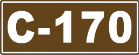 Second-level autonomous road. Brown background (#63431A) with white letters (#FFFFFF).
 Third-level autonomous road. Yellow background (#FFDD00) with black letters (#000000).
Although the color codes probably don’t match exactly what we currently have, I think the only one visually affected is the first-level one, since we have it in yellow and it should be orange. Additionally, it has some white borders that don’t make sense either.
Then we could go into details about the straight or curved edges of the identifier, or whether it has an extra border like in the case of toll motorways or second-level autonomous roads. To me, that is practically imperceptible and I wouldn’t go into so much detail, so I would set toll motorways as a normal motorway. Although if someone wanted to be very precise, they could.
There is also the issue of autonomous roads with their own identifiers that are only used at the autonomous community level. In my opinion, this is more open to debate and I don’t think it’s worth detailing unless there are complaints from other editors.
I understand (from what I’ve discussed with other editors) that this matter doesn’t depend on us, but rather on the Waze staff. I believe it’s something worth insisting on because we currently have many roads with an incorrect identifier, or no identifier at all because we can’t put the correct one due to the character limit.
I’d even go further; I think it would be good if they let us editors modify these identifiers ourselves. But that’s probably a battle for another day—if they have it set up this way, it must be for a reason.
Sorry for such a long post, but I felt it was necessary so everything could be understood. If you’ve made it this far, thank you very much and have a great week!!
PS: If they ever make the change, something tells me we’ll have to modify all the turn instructions that used the old identifier, because that probably won’t update automatically. But oh well, worse things have happened, and that just means more extra edits  .
.

 .
.