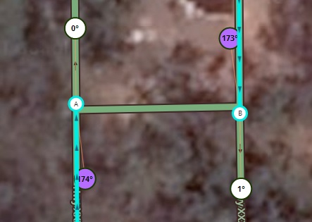
In case of side street combination it’s better to change the elevation of the u-turn segment.
It’s should be clear that the “leg” of the u-turn segment should be very very short. Otherwise it will be visible at the client and all the map will rotate at this point (from my experience in thailand…).
Thanks for the great guidance.
Why do want to do this? Waze wants us to map to reality.
And elevation will be shown in the app. (even thought it is a very small segment) There seems to be a “ghost” story about swapping to another segment when crossing, but that was looooong ago. And if you have a route enabled you’ll stay fixed on that segment.
Thanks, we’ll add that to the instruction. The visual of the segment itself would be minimum, but weird map rotation is not desired Good to have an experienced wazer who already did a couple of uturns!
EDIT: to make the wayfinders/doglegs as short as possible, you’d have to set the snapping control to snap-distance 5 or even 0, in your WME toolbox settings. We might want to add a short instruction for that?
Many many complex junction include special segments just to help the routing.
Those segments are with different elevations to prevent the error of two crossing segments with the same elevation so visualization of the elevation at the client will be a big problem…
From my experience, it’s possible to make very small leg of the u-turn segment if you move temporary the node of u-turn to the side, move the point of the leg to the correct point and then move back to node to place that will give small tail the angle of 170 or more.
I consider the save-warnings in WME less important then actual results in the app.
It’s a Validation of your edits, with a Warning do double check, not an error. (but this is not the first time somebody suggest that to me)
The warning is similar to the irregular shape and unconnected segment. Sometimes you just want them to be like that and you click “save” anyway.
That’s also a good way, perhaps we can setup a short “How-to” for that as well.
If we do this, we might also provide guidance on just how long the the wayfinder/dogleg should be? 1 meter? So far I have made most of mine 3-3.5meters, i could not get less without it snapping onto the other segment.
I like the “Make a U-Turn” notification, but I do think that we need to map the decelleration lane for U-Turns on Freeways and Major highways.
I’d like to hear what others think, but the standard has always been to map where the turn lane actually departs, particuarly if it is a long turn lane. That way tts will say " in X km keep right" before you get to where you actually ‘keep right’. It’ll also give the additional command ‘keep right’ exactly when you get to where the lane splits off to the right. As I understand it, that is the main reason for AGCs and is one of the reasons you make them (for the cases where the driver needs more notice to get to the right or left). For small roads, it doesn’t matter, but for busy highways or busy intersections, I think the additional notice is important. Along with the final “keep right” command to come where the lane splits off.
Again, this doesn’t matter at all or apply to short lanes or no lanes.
I agree with Pacman. Should use Arno’s new and improved long deceleration lane version, which uses one segment for each direction.
Also, should we add a tips section on how to get the dog legs shorter? I don’t care for the giant doglegs (except to make illustrations easier). I imagine those larger one will render rather funny in the app.
From a pure rendering POV, when using mH spaced at 20m (more than they should be to prevent routing across the straight segment when you have cross streets), the size of the dog legs makes almost no difference.
Agree with the U-turns, with the following comments/questions:
In the U-Turn / side street combinations, I’ve been setting the elevation of the “Z” segment to 1 to avoid the “intersecting segments are not connected” warning.
I suggest we lock ALL Z segments to a minimum of 2 so novice editors don’t accidentally turn U-turns to spaghetti.
With regards to the elevation: yes, it takes care of the warning in the editor, but the difference in height actually shows up in the app, while just having a warning in the editor does not affect the navigation. But I will let Arnoniem chime in on this if needed.
My opinion is in the previous page
Especially lifting the Z to 1 will highlight the segment which is not desired. I.d rather change the elevation of the crossing street because that will dissappear probably under the FW out Hwy segment.
But again imo it’s not necessary to act on this wme warning.
And locking for sure. I used to lock m at 5 since the shape was rather unknown and the angles are critical.
So as high as you can would be my recommendation.
 Good to have an experienced wazer who already did a couple of uturns!
 and you click “save” anyway.