Good afternoon, I’m creating this post so we can report and discuss the issue of Waze taking you off or onto highways just to take the next entrance or exit and supposedly «save» time. Personally, I have experienced this myself and have also handled several URs reporting the same issue, so I think it is necessary to discuss it.
Heading south on Autopista Central / Eje Gral Velasquez, it recommends entering the highway, passing through the TAG toll gantry there, and then after a few meters taking the exit to Alameda / 5 de Abril.
https://waze.com/es-419/editor?env=row&lat=-33.44525&lon=-70.69085&marker=true&zoomLevel=17&segments=105089517,152195008
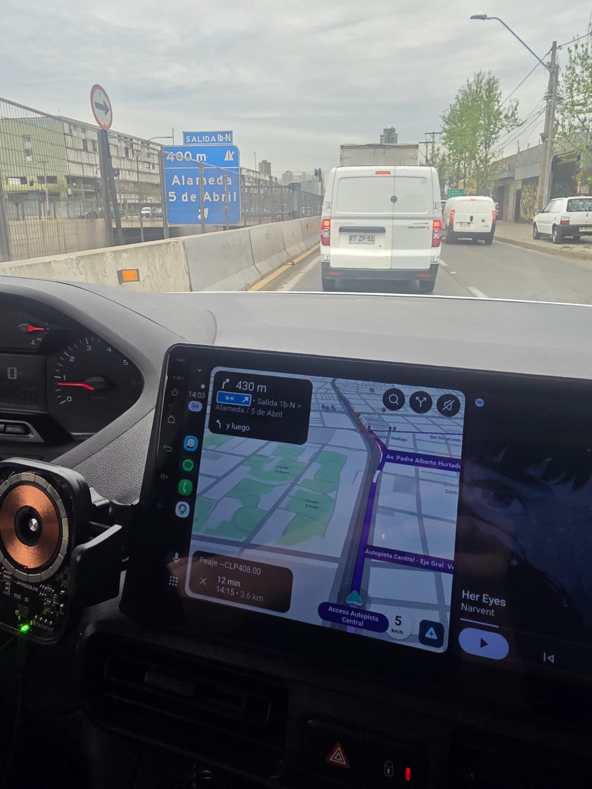
It’s a long-standing issue, and it doesn’t only happen here: I was living in Rio for four months, and it also happens there on the highway between Leblon and Barra de Tijuca. I wish the staff would do something to fix it.
Indeed, it’s an issue that has been going on for many years! The post is mostly to highlight the problem and, as far as possible, resolve the specific cases that pop up.
Fact: in Chile there is no penalty for tolls, so I would understand that it makes no difference whether you take the highway or the side road under ideal traffic conditions.
As a consequence, Waze can take you off or put you back onto the highway (or vice-versa) if there are no other restrictions or penalties.
So, what penalties could affect this?
There is one regarding mini-detours, which is the situation described by Benjamín in this thread. A “virtual” time penalty applies there, though I don’t know what it might be, and if it is still faster to take the detour than to go straight, Waze will choose that option.
Another relates to the continuity of the segment names of the road, whether as a primary or alternative name. The penalty is minimal (or zero) when the road name is maintained, and increases with each name change. I don’t know if the case in the previous paragraph is based exclusively on this or has special rules… after all, doing that and discovering a shortcut is one of Waze’s charms. The point is how much time savings justifies leaving the known (and safe) route.
Another penalty is the configuration of options like «Avoid highways» and «Avoid toll roads». These are very high, but they are not absolute blockers, meaning that if there is no other possible way to reach the destination, Waze will use those roads anyway.
Yet another one is the TAG (electronic toll device). In this case, I’m not sure if the behavior is similar to the previous one, but it probably is.
Therefore, it will depend on both traffic conditions and settings combined to determine if it will take you off your «obvious» or «expected» route to save a few seconds (and, perhaps, increase stress).
An issue known for yeaaars, let’s see if we can make the most of the new tools.
Near Vespucio Sur and Av. La Serena (La Granja, RM), I set the frontage road to a different ground level than the highway, we’ll have to see if it works for this case or another.
If not, I thought of something else. For those specific cases, see if adding a far turn works between the 3 segments of the frontage road; before the entrance, during, and at the exit of the highway.
Traté de hacer lo mismo acá que hizo Cristhofer en La Granja acá en San Bernardo, pero no me resultó o lo hice mal, yo creo que mejor sería agregar una caja de intersección en este caso.
https://waze.com/es-419/editor?env=row&lat=-33.59572&lon=-70.71355&marker=true&zoomLevel=16
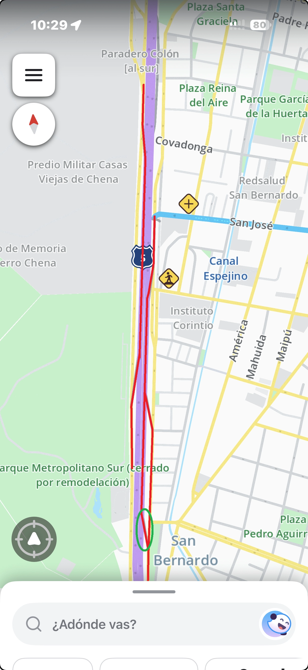
Las rutas en rojo deberían ser eliminadas con una caja de intersección; estaba debatiendo si incluir el acceso con el circulo verde, ya que igual te evita todos los lomos de toro de la caletera, pero en mi experiencia te hace entrar siempre incluso si hay tráfico por la autopista.
Listas, favor revisar.