The street I live on is becoming a dead end. How do we go about updating this in Waze maps?
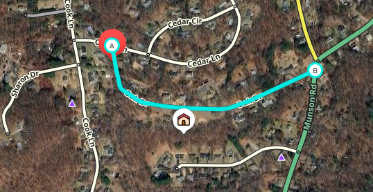
Oak Dr in Beacon Falls is now a dead end. The only entrance and exit will be off Munson Rd. The entrance/exit from Cedar Lane is being closed as of 6/13/2026. How do I get this changed/updated in Waze?
If you share a PermaLink from the Waze Map Editor, we can have a local map editor respond to the request and make the change on your behalf.
Otherwise, you’ll need to submit subsequent map edit suggestions to the road to accomplish the task. Each change may require an approval from the community before you can proceed to the next step.
However, we can walk you through it if you prefer. I’ll move this post to the United States > Connecticut forum so you can receive local support.
Hi Editors,
I’d appreciate your help with a map update.
Permalink: https://waze.com/en-US/editor?env=usa&lat=41.44507&lon=-73.03838&marker=true&zoomLevel=17&segments=9085451
Reason: As of 6/13/2026, Oak Dr in Beacon Falls is becoming a dead end. The only entrance and exit will be off Munson Rd. The entrance/exit from Cedar Lane is being closed as of 6/13/2026. This road change has been approved by the town since Oak Dr is a private road.
Thank you in advance,
Good evening,
I’m one of the New England region editors. I’ve read your request and have found lots of documentation about Oak Dr being a private road but being maintained by the town. The only minute notes I could find are from 2021 regarding failure by the town to plow. There are no mentions in more recent Bd of Selectmen minutes regarding either Oak or Cedar.
I called the Police Department but the resident trooper in town was unable to verify that this disconnect was going to occur. Can you point us towards any documentation of this change?
Currently that segment is marked as a private road which means that no one will get routed across it on a Waze app - the penalty is set very high. However, people who want to arrive on that street would be inconvenienced by being sent to Cedar, if it is being closed off. Therefore, we really want to help but getting proper documentation is how we protect the map we all share on Waze.
Thanks,
Thanks for getting back to me.
I will work on getting documentation from the First Selectman. This was a new change recently approved. Since it is a private road the residents are in charge of maintaining it (paving and filling in potholes). The agreement with the town is that they will plow it as long as we keep it maintained. To help with our maintenance efforts, we needed to lower the amount of traffic cutting through, hence turning Oak Dr into a dead end, closing off the entrance where it meets with Cedar Ln (point A shown below). Thanks again for your help and advice.
Hello, and thank you for the feedback. Can you provide a link to the municipal notice about this change, or provide a picture to the newly closed road? Once this can be verified, we can make the requested update.
Please come back to the community when construction of physical barriers is nearing complete. A visit by a local editor was unable to confirm the conversion of this road to a dead end street or cul-de-sac.
The construction of physical barriers was completed as of this Sunday, 6/14. Thanks!
Great. Feel free to post some pictures and video of the new barriers. Otherwise, we may have to wait for official documentation from the town, or a visit from our local volunteers.