Thanks @pironic for grabbing the segment.
@nlindq, firstly welcome to the forums!
Manually road closures are limited to L3 and special permission (ie. partners) - We do do get Edmonton’s Disruptions feed automatically imported into Waze and for the vast of [segment] closures, they are correctly added as-per defined.
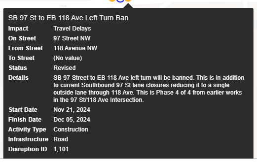
There are some entries though that don’t/cannot get identified as a closure, SB 97 St to EB 118 Ave being one of those as its just listed as a left turn ban - the feed does not (yet) add closures to turns. Between that and language (eg. lane closures), they don’t get automatically added.
As you mentioned all EB 118 Ave was closed, we did add a segment closure instead of relying on the Edmonton alert. If we got it wrong, its an easy fix.
We can certainly manually add them - as @pironic mentioned, we have a community discord server you can relay details into.
You can also reach-out via the forum/unlock sub-forum (with “closure” or “road closure” in the headline) and some will definitely get to for you.
There is also in-app/in-car. (in-car + CarPlay, Android Auto , and Android Automotive)
If you’re using in-car, there isn’t a direct report for closures*, but you can just do a general map problem and an editor will follow-up
In-app, there is a closure report, but its recently changed - were as before you had to choose a direction of the closure, its more predictive now to make it safer while driving.
Example, if you have a left turn coming up and its closed, when you Report > Closure, it will apply a closure to that turn/movement, cause you were being routing, and recalculate for you.
*There is also a new auto detection closure now, in-app and in-car that if there are enough users on a high priority road, it will automatically apply a closure - this is still new as of this year, but I have seen the detected closures applied pretty quickly.
Hope this gives you some answers, if you have any questions feel free to reply, DM, what be it - happy to answer more.