I have been by asked by the Beta forum to post to the local group the following:
Waze refuses to use the best (shortest/quickest) directions from my location in lower Westchester County to Killington, VT. I have been driving this route with Waze since it’s inception and Waze will simply not use my history. This is route that Waze presents (or as an alternative 84 to 87), it simply does not like the Taconic State Parkway. My route is 20 miles and 30 min shorter, but uses 2 lane roads. When on 684 heading north, it will still want to take me east on 84 back to 95/91 vs. west to the Taconic.
Waze never presents this route as an alternate route, even on the route, I am forced to enter a waypoint in order for it to get close to following this route.
[i]https://www.waze.com/live-map/directions/us/vt/killington/brad-mead-drive?to=place.ChIJu9tmaKYp4IkRoP7vizP2skY&from=place.ws.na.6494530.200[/i]
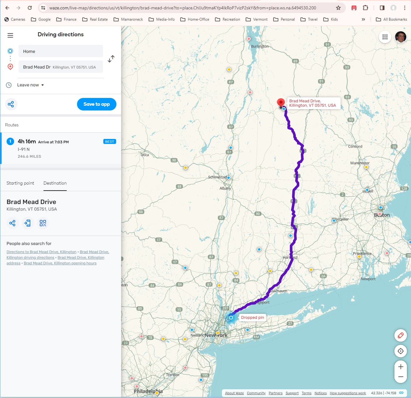
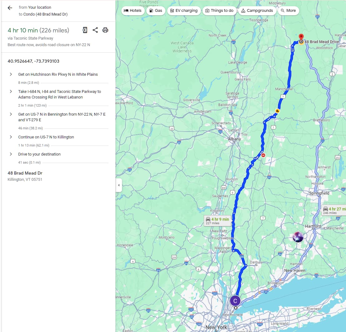
As an aside, Waze will not use the Bronx River Parkway, when it is always a few min faster between Mamaroneck and White Plains (Hartsdale), it wants me to go several miles out of the way on Hutch to 287 to Tarrytown Rd. Again this uses more 2 lane roads, but I always beat the projected time and my route is never shown as a alternative route.
This is an issue I have seen pop up a couple of times over the past 10 years, but there’s not a great fix to it unfortunately based on the way the app works. It’s not the Taconic that’s the issue, it’s the state/federal functional classification of NY-22 between US-20 and NY-7 that makes it undesirable in the middle of a longer route (where Waze wants to stick to major arterials, US highways, parkways, interstates, etc.).
Before I dig in and try some testing out:
- Can you confirm you do not have “avoid tolls” set, otherwise Waze will not route you between Exit B2 and B3 on the Berkshire Spur
- Can you provide a more specific starting point? It doesn’t have to be exact, but maybe a convenience store or business around the corner / within a couple blocks.
For the Bronx River Parkway, please also provide a more specific start and end than just the municipality names. Thanks!
I made some changes to NY-22 as a test, and they should go live in the app within a few days. Unfortunately, there was a culvert damaged between New Lebanon and Stephentown, so a section of the road is closed through the end of April. It’s a significant detour since there aren’t many alternate roads through there, so we may not be able to make sure it’s actually working until May when the road reopens.
Please still let us know about your navigation settings and some addresses we can use for start/end testing for this route and the Bronx River Parkway.
This is a good starting point: 540 Mamaroneck Ave, Mamaroneck, NY 10543, but I could start anywhere in the area with the same result.
There actually is a detour around the 22 closure that is shorter and adds no time to the trip. I will be making this trip in 2 weeks and will advise if anything has changed.
Thanks, for the effort.
The changes did not affect the drive. Waze still only wants to use 87 or 91 to head north resulting in a significantly longer trip. Let me know if there is more information that I can provide.
Thanks,
That culvert work in Stephentown ended over the weekend so I was able to test the routing last night and this morning. It seems both the 91 route and the Taconic route are within a few minutes of each other most of the time. I think what is happening, is that on the server side, Waze does put a little bit of a penalty in for tolls, even if you have the avoid tolls off (it gets much larger if you have avoid tolls set), and that is negating that few minutes saved on the Taconic.
I’m going to try something with NY-295 (last exit on the Taconic before the Berkshire Spur), which is actually 3 minutes faster to NY-22 than taking the spur for that short section. Again, it will take a day or two to reach the app before I can test it.
I’m still not sure this will solve the issue overall - I really have to break your whole drive down piece by piece and see where Waze is potentially ignoring it, but I don’t want to make more than one set of changes at a time so we can isolate the main culprit. I can say, it looks like everything works fine once you get on 84 off of 684, but it would be great if you didn’t have to set an I-84 W waypoint.
Success - Let me know if this works on your end!
It’s going to be highly dependent on traffic, given that the two routes are typically within 5-10 minutes of each other. For example, right now, it goes up the Taconic but the the return route would be the 95/91 route. That shifts depending on the time and day of the week, as well as whatever is going on in real time.
EDIT: Tested the route from a few different spots. The Hutchinson/684 split seems to be the major deciding point - right now the route form that spolit are within 1 minute of each other. So if you’re not getting the route you want, but can get to the start of 684 without needing navigation, Waze should give you your preferred route after that (unless there’s some major traffic or closure on 684, 84, or the Taconic). 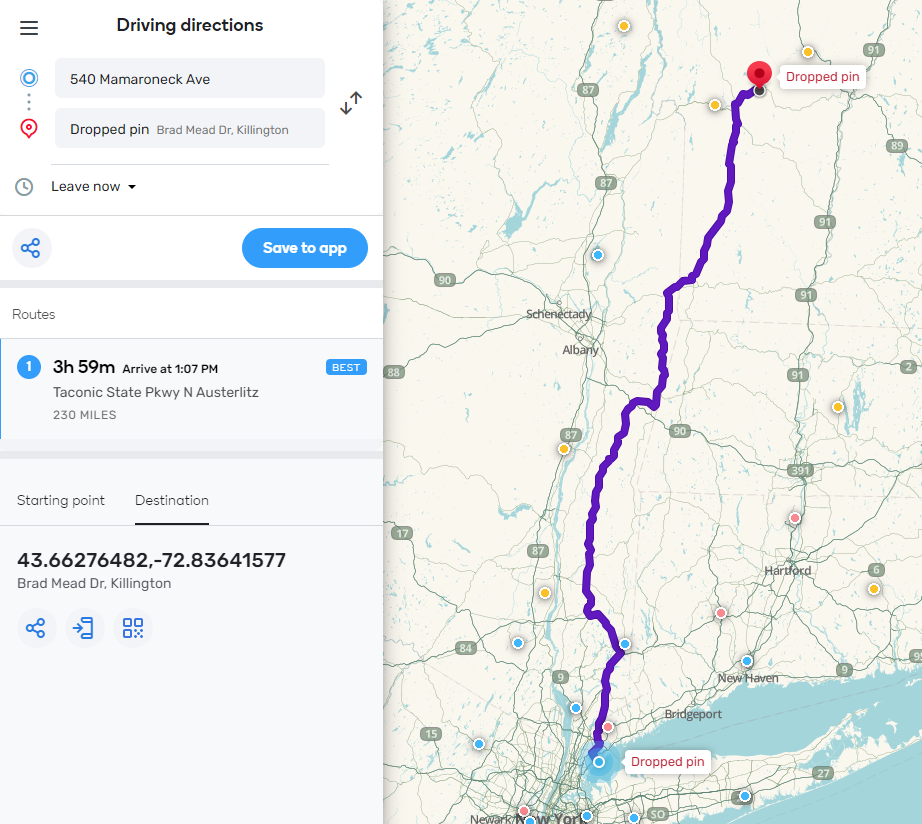
Thanks I will advise. The confusing part is in real life, the Taconic route takes me significantly less time (about 20 min) than the 95/91 (248 miles) or 87 (246), I know the speed limit is faster, but Waze know my average speed (a bit over) and calculates that in my time.
I appreciate the effort.
Different route question: Why does Waze want me to exit I-95N in NJ at RT 46 to the GW Bridge vs. continuing on I95? It is always faster to stay on 95 and I never know if there is actually traffic at the bridge that would be avoided if I took the 46 go around. I just trust my instincts and 99% of the time it’s 1-2 minutes quicker (immediately tells me that when I go past the exit for RT46).
Made the drive last weekend and it sent me on this route. Whatever you did seems to have worked.
Thanks,