During a crisis, accurate information about shelters and donation centers is vital. When a user searches for “help” in the Waze app, these locations appear as dedicated pins to help them find safety and resources.
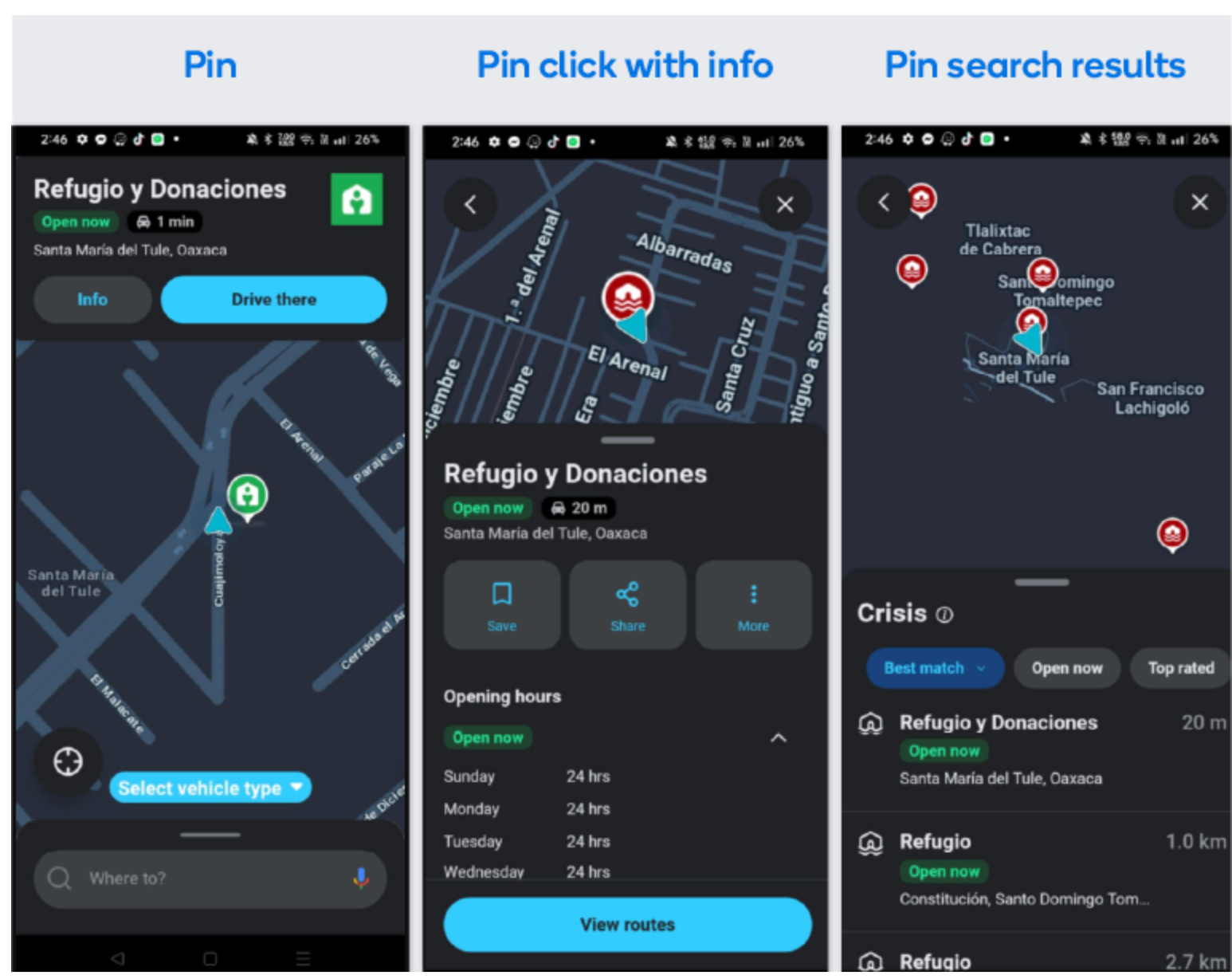
Two methods are available for adding these locations to the map. Method 1 is recommended for immediate updates.
Important: Adding shelters to the Waze Map Editor (WME) is typically restricted to Level 4 (L4) editors.
Method 1: Add a Place via WME (Recommended)
- Log in to the Waze Map Editor.
- Enable the Places > Public layers.
- Enter the target location in the search bar.
- In the left-hand sidebar, hover over the Add icon.
- Navigate to Place > Crisis locations.
- Select the applicable location type (e.g., Shelter location or Donation center).
- Pin the venue’s location on the map. The left-hand panel will expand with the Place’s details.
- Turn on Show on map
Tip:
- Map visibility: Only activate this toggle when the Place is or is about to be open to the public, as it instantly pushes the location to appear on the map
- Search visibility:
- If the Place has been previously indexed, it will also appear in search immediately
- If the Place is new, indexing for search may take up to 24 hours
- Fill in the following details:
-
Address: Enter the address accurately based on the official source
-
Name: Enter a name following this format: [Type] - [Formal name]
- Tip: Include crucial information, such as “No pets” or “Women only”
- Examples:
- Emergency shelter - Anycity Town Hall
- Winter shelter (No pets) - Villageton Community Center
- Sandbag distribution location - Main St & Cross Ave
-
Alternate names: Enter an alternative name for the shelter or donation center
- Note: This field is not shown to users, but can be helpful for search optimization
-
Categories: Skip this option. Do not add additional categories. Crisis locations should stand alone, and be separate from their host Places.
-
Description: Enter crucial information for those experiencing the crisis. If there’s information that would exclude any of the public, consider noting it in the “Name” field.
-
Entry points:
- Click +Add point. A node will appear on the place’s pin.
- Drag the node in the direction of the the place’s entry point
- Rename the point
- If the entry is the building’s main entry, select “Main”
- Click Apply
-
Lock: Select an editor’s level to restrict edits to the Place
-
Note: By default, in the United States, Crisis Places are locked to Level 4 editors or higher
-
External providers: Do not link these to existing venues (like schools or churches). Crisis locations must stand alone.
-
Website: Enter the website URL of the shelter or the organization in charge of the shelters (for example, the Red Cross)
-
Phone: Enter the venue’s phone number
-
Services: Select all that apply
-
Note: If available, always select “Customer parking” . Nearby PLAs are offered to users, and non relevant results may be shown if the crisis location doesn’t have “Customer parking” selected.
-
Open hours:
- Under “Open hours”, click +Add Open Hours. A popup will appear.
- Add the opening hours for the crisis location listed in the source documentation, or 24/7 if the crisis location is assumed to be available throughout the activation
- Click Add
- Click Save, in the top bar
Tip: It’s a good idea to maintain a spreadsheet of Crisis locations by region/state, including Permalink and a column indicating if the location’s “Show on map” toggle is enabled.
Method 2: Use the crisis pins spreadsheet
In some events, the Waze Crisis Team will share a dedicated Google Sheet to collect locations in bulk. Waze staff then uploads these as pins.
Important: Each field has a character limit. The columns in orange are automatic character counters that turn red once you are over the limit. If what you are trying to enter is too long, shorten it in any way that will still be understandable to Waze users.
Fill out the spreadsheet following these guidelines:
Mandatory columns A-F

- Status: Choose the relevant status of the shelter. Did you just add it to the spreadsheet, or did you update the information? Is the shelter closed? Waze staff also updates this with what they did with the information.
- Community actions:
- New: You added a new shelter to the spreadsheet
- Updated (Community): You updated information for an existing shelter
- Disabled (Community): You notified Waze staff that a shelter is no longer active
- Uploaded (Community): You uploaded the venue to the WME
- Pending Staff to disable (Community): You reported a shelter as inactive, and Waze staff is verifying and disabling the shelter on the Waze map
- Waze Staff actions:
- Uploaded (Waze Staff): Waze staff uploaded the shelter to the Waze map
- Updated (Waze Staff): Waze staff completed all updates to the shelter’s information, replacing the “Updated (Community)” status
- Disabled (Waze Staff): Waze staff disabled the shelter
- Community actions:
- Comment: If you updated existing information, tell us what you updated. This helps our team make the correct changes.
- Pin name: Enter the name that appears on the pin. It should be “Emergency Shelter” in the local language, or any other name that accurately and concisely describes the pin (evacuation center, emergency shelter, donation center).
- Address: Enter the street name and building number of the shelter. This often goes over the character limit, so shorten it as much as you need to keep it at or under 50 characters while still being understandable. This isn’t how we locate the pin, so don’t worry if it isn’t the exact abbreviation.
- City, State: Enter the city and state where the shelter is located. This has a 50-character limit.
Optional columns I-O

- Additional info: Enter the name of the shelter or access information. This has a 30-character limit.
- Long description: Enter any additional information about what services the shelter provides. This has an 80-character limit.
- Phone number: Enter the phone number of the shelter
- URL: Enter the website URL of the shelter or the organization in charge of the shelters (for example, the Red Cross)
- Venue ID: Enter the unique ID number that you can find at the top left corner of the venue in the WME
Mandatory columns P,Q,R: Coordinates
You can either enter a permalink, which automatically populates the latitude and longitude, or you can enter the coordinates directly in the Lat/Long columns.
Got questions?
How long does it take for a new shelter to show up?
Places added in the WME appear almost immediately. However, it may take up to 24 hours for a brand-new location to be indexed and searchable by name.
What should I do when a shelter or donation center closes?
- In the WME: Turn off Show on map. Do not delete the venue. Keeping it allows you to reactivate it quickly for future events.
- In the pins spreadsheet: Update the Place’s status to Disabled (Community)