
This page is a supplemental mapping resource page for editors of Arizona. All guidance specific to Arizona can be found in the Southwest region wiki. Other states in the Southwest region include California, Colorado, Hawaii, Nevada, New Mexico, and Utah.
To get in contact with the Southwest editors please use >> this link << to join the Southwest Region Editors on Discord. Discord is the primary communication platform for Southwest editors.
If you have questions about this page or it needs updating please visit [Page update] Southwest Region (SWR) Wiki and reference this page, Arizona Mapping Resources.
Mapping resources
Arizona’s State Highway System
An interactive map showing Arizona’s highways.
RailRoads of Arizona
An interactive map showing all of Arizona’s RailRoad network.
Arizona Mileposts
An interactive map showing the location of all the Arizona Highway mileposts.
Arizona Highway Rest Area
An interactive map showing all of the Arizona Rest Stop locations.
Valley Freeway Nickname
In every city, transportation landmarks are given nicknames. It can be very confusing to anyone not familiar with the area. This is a list of nicknames for all the valley freeways.
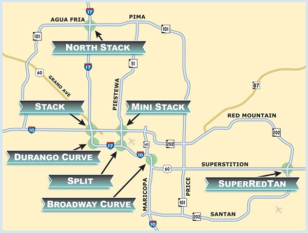
Stack – A four-level interchange connecting I-10 and I-17; located west of downtown Phoenix near 19th Avenue and McDowell Road.
Mini-Stack – A four-level interchange linking I-10 to State Route 51 and Loop 202 Red Mountain Freeway; located south of McDowell Road and east of 16th Street.
North Stack– Another four-level interchange, this one is located at the I-17 and Loop 101, north of Bell Road.
Split– The interchange where I-10 splits or merges – depending on your direction of travel – with I-17 near Phoenix Sky Harbor International Airport. Westbound I-10 splits into lanes that allow drivers to head north on I-17 or continue west on I-10.
SuperRedTan– A multi-tiered interchange in east Mesa where US 60 Superstition Freeway, Loop 202 Red Mountain and Loop 202 Santan meet. SuperRedTan is formed by taking part of each freeway’s name – Superstition, Red Mountain and Santan.
Broadway Curve– Southeast of the Split, this rush-hour-challenged section of I-10 is near Broadway Road, and SR 143, by the Phoenix-Tempe border.
Durango Curve– The curved section of I-17 near Durango Street is located southwest of downtown Phoenix.
Functional Classification
Arizona is following the Functional Classification (FC) system for the USA.
ArcGIS Functional Classification This version of the map will give you an error when zoomed to the entire state because it has too much data to load. If you zoom to a location, it will show all of the road segments.
This is the Arizona Department of Transportation APLAN ArcGIS Functional Classification map. This is the interactive map that all Arizona editors are to use when establishing FC implementation into the Waze Map Editor.
Arizona to Waze Functional Classification conversion
ADOT GIS class and color description

The Arizona Classification and Color scheme come from the official Arizona D.O.T (ADOT) Functional Classification (FC) map that is published by ADOT. The legend shows what classifications ADOT uses and what color is assigned to each class.

This screenshot shows how the FC and color scheme appear in the GIS map.
ADOT to Waze conversion table
Important Note
Arizona’s Functional Classification settings are dictated by the Arizona Department of Transportation (ADOT), at the request of the local jurisdictions. If you do not agree with our FC levels, please petition ADOT to change the rating they’ve assigned.
 |
Regarding FC and roads on Native American (Indian Reservation) land. As Waze AZ strictly follows the State FC, the reservation roads in AZ may differ from what Waze common standards may be. The State FC takes into account certain issues on reservation roads, as in, differences in laws, local opinion on basic public access, and also a lack of public services which can also mean a lack of safety. Although a reservation road has the possibility of being a shorter route, we will not sacrifice time and distance in lieu of the issues stated above. Also note that some reservation roads, although dirt, may be classified as street or even PS (if state FC dictates PS), as that road may be the main, and only road in and out of some communities. |