
This page serves as the primary resource for editors of New York. Review all the sections to better understand how the guidelines for this state might deviate from the overall regional, USA, or worldwide guidelines. If you have any comments or questions about this page or state refer to the community links below.
Introduction
New York is a part of the Northeast region, which includes the states and/or territories of:
Delaware / New Jersey / New York / Pennsylvania
See the Waze glossary for an explanation of Waze terminology.
Mapping resources
Before editing the maps in New York, be sure to fully review and understand the editing manual.
The Waze user community follows the Waze etiquette guidelines discussed in the Wiki. Be sure to familiarize yourself with these guiding principals while editing the maps and this Wiki, as well as when communicating with other Waze users.
The New York map editing community has compiled a list of state-related GIS and mapping resources to assist with editing. See the New York Mapping Resources post in the New York Discuss forum.
Map Editor Scripts
Once familiar with the fundamentals of map editing, editors are strongly encouraged to install the following WME Scripts to assist with your editing experience: WME Toolbox, WME Place Harmonizer (WMEPH), WME GIS Layers (GIS-L), and WME Junction Angle Info (JAI). These helpful tools not only identify potential problems (and sometimes suggest solutions), but also ensure your edits align with community standards and provide you with access to local public mapping resources. If you have any questions about installing or using these scripts in WME, don’t hesitate to ask the community.
Editors in New York may also find WME Validator and the NY Localization Package for WME Validator scripts useful. The localization package customizes Validator with our unique standards and guidelines, and adds three map resource buttons (for NYS Orthos GIS maps, NY DOT FC Viewer, and NYCityMap). Instructions for the localization page are available in the New York Discuss forum.
Additionally, the WME Open Other Maps script has been customized to include the three map resources buttons in the localization package, plus map buttons to the NYS DOT Posted Speed Limits Map and 511NY website.
Community
The Waze Discuss forum is a great place to find answers to previously asked questions and also a place to ask new ones. Below are links to the forums specific to New York.
Editors from throughout the country can be contacted through the USA Waze Chat group in the top right corner of WME, Waze Discuss, and in-app chat. Community leaders for the New York community, including Coordinators, State Managers, and Area Managers, can be found in the table at the bottom of this page.
Discord
Like the rest of the US, the New York community uses Discord as its primary communication platform. Please join us in the Waze NOR Editors server and ask to have the New York role added if you plan to edit in the state.
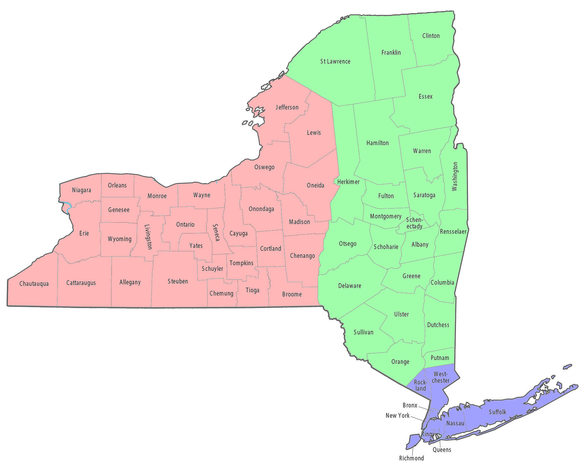
The conversations are segmented in channels by areas and topics. For New York state there is a general state channel, and then three local channels; #ny_state_east, #ny_state_west, and #ny_greater_nyc_li. This image indicates the general division for the local channels.
Update Requests
New York uses the 0-4-4 timeline established by the Northeast Region Community to respond to and collaborate on Update Requests (URs). Please see the Northeast Region Wazeopedia page for more information about this methodology and region-specific guidelines for responding to URs.
Cities and towns
One of the most common errors when editing the maps is when an editor creates a road and does not confirm the road by setting the city and road name (or stating it has none). Further, Duplicate cities can be caused by incorrectly named segments and should be corrected following the guidelines in the duplicate cities article.
Segment city names within the state are based on administrative divisions of New York State. As almost all land within the state is incorporated, every segment should generally have at least have the city name of the incorporated village, town, city, borough (NYC only), or Indigenous Nation/Territory (when applicable) that the segment is within and should not be listed as “no city”.
Additionally, the state has hamlets, census-designated places (CDPs), and neighborhoods that are treated with quasi-official status in some portions of the state and may have been included with the original basemap import. Some of these areas may coincide with USPS names, but typically do not have the same boundaries. In areas of upstate New York, hamlets and CDPs may have large areas with small populations and need not be mapped in rural areas, whereas counties such as Suffolk, Nassau, Rockland, and Westchester have smaller areas with high populations that fall under that quasi-official status (e.g., Suffolk County provides hamlet boundaries in its county GIS). Check with state leadership before adding or removing a hamlet, CDP, or neighborhood name from a segment, as it may or may not be preferred over the incorporated / administrative name.
New York City neighborhoods are currently not used as a city name; use the borough name in these areas.
Major roads
New York follows the general road naming and road type guidelines of the USA.
Local Naming Variations
-
New York State uses NY-## and NY-##X for all state routes and their spurs, loops, etc. (e.g. NY-27, NY-787, NY-17M, NY-52 BUS)
-
Concurrent routes which are signed/shielded with both names, AND commonly referred to using both names together, should use both names separated by a bullet (•) as the primary name, and each individual named as an alternate name. (e.g. US-1 • US-9)
-
Interstate highways which also have a historical or local freeway name should have that historical or local name appended after the Interstate designation, separated by a bullet. (e.g., I-495 E • Long Island Expwy, I-95 N • Cross Bronx Expwy, I-87 • NY Thruway)
-
Highway name descriptors, such as TRUCK, EXPRESS, etc. should be added in ALL CAPS after the name. (e.g. US-1 TRUCK, or on a concurrent road US-1 TRUCK • US-9 TRUCK)
Service roads
-
Roads which have a parallel service road (i.e. are split in a single direction such as Ocean Parkway) should have the service roads named uniquely so Wazers understand which roadway they are being routed onto. These are commonly referred to as service roads in New York, but may also be known as frontage roads, or outer roads. They should be named with “(Service Rd)” following the actual road name. (e.g. Ocean Pkwy, and Ocean Pkwy (Service Rd).) This will also identify which roadway incident and error reports were sent from.
Please see the House Numbers on Service Roads article for a detailed explanation and tutorial on setting the road type, and adjusting House Numbers for these service roads so they route correctly, and work with BDP.
Road Shields
New York State uses the following nationally-available shields:
| Shield | Use Case |
|---|---|
 |
Interstate Main for interstates |
 |
US Hwy Main for US Highways (Routes with descriptors such as ALT, BUS , SPUR, etc. should use their respective shield) |
 |
CR generic Main for county routes |
Available state-specific shields include:
| Shield | Use Case |
|---|---|
 |
New York - State Main for state routes |
 |
New York - State BUS for state business routes where signed |
 |
New York - State TRUCK for state truck routes where signed |
 |
New York - State Road NY Thwy should be added to the NY Thruway alt name on segments carrying the Thruway so it can be used for on-ramp signage Only the non-interstate section of the NY Thruway Berkshire CONN should use this shield for its primary name / display |
 |
New York - NYC Pkwy (square) for New York City parkways, matching letter abbreviations on the parkway signs |
 |
New York - State LI Pkwy (lighthouse) for Long Island parkways, matching letter abbreviations on the parkway signs |
 |
New York - State Pkwy (Empire Shield) for most state parkways outside of New York City and Long Island. Use the first letters of the parkway name as an abbreviation on the shield (e.g., TSP for Taconic State Parkway). Exceptions are the following state parkways and their shields listed in the following lines below |
 |
New York - Lake Ontario Pkwy for the Lake Ontario Pkwy |
 |
New York - Niagara Pkwy for the Niagara Pkwy |
 |
NJ & NY - State Pkwy Leaf for the Palisades Interstate Pkwy |
 |
New York - Long Mountain Pkwy for the Long Mountain Pkwy |
Where not to not add shields
- State reference routes should not be shielded. These are identified as 3-digit numbers in the 900’s with a single letter suffix (e.g., NY-910C, NY-970G). Two reference routes have signed primary names and are the only shielded exceptions (NY-961F & NY-990V).
- If you find a missing shield type, please reach out to state leadership so that the new shield type can be requested.
Functional Classification (FC)
New York State has upgraded the entire road network to meet the national guidance for road type classification. This ensures a consistent, and better navigational experience to wazers around the country. The general guidelines for implementation are in the Road types page. Any local deviations, and special information for New York State are listed in the next subsection.
The New York Mapping Resources post has links to several FC data sources including a State DOT maintained GIS, CSV lists of all FC roads by county, and general FC information.
Tip: for editors using the FC Color Highlights script, the following colors will more-or-less match the NYS DOT FC map:
| NYS FC Type | Highlight Color |
|---|---|
| Interstate = FWY | Black |
| Principal Arterial = MH | Green |
| Minor Arterial = mH | Red |
| Collector = PS | Blue |
Local Exceptions
-
Roads which are Private (not accessible to the general public i.e. a gated entrance, buses only, etc.), Parking Lot Roads, or Non-Drivable (i.e. pedestrian plazas, boardwalks, etc.) should be classed as such (Private, PLR, Non-Drivable), regardless of what their official FC class is.
-
The NYS FC GIS is incomplete, and does not show all roads highlighted correctly for the full length on the road. When in doubt consult the Inventory Lists.
-
The NYS FC GIS will only highlight one direction (side) of a split roadway, in these cases both directions should be classed the same (at the highlighted class).
-
New York State Reference Routes should use their FC designation and not be treated as state highways.
From this point, roads may be adjusted up or down the scale as indicated by the road’s setup and usage ONLY with the consensus of the local RC or SM team. Some specific examples of these exceptions include:
-
Most of NY-17 from Binghamton to Harriman is fully limited access; it is therefore typed as Freeway (except for one 5½-mile stretch of at-grade intersections between Sanford and Hancock, where it is typed Major Highway).
-
CR-56 in Steuben County is barely wide enough for two cars, has no appreciable shoulders, and is only rarely used; based on that, its type was downgraded to Street.
-
Several minor arterial state routes across the Adirondack Park have been given +1 routing preference to act as Major Highways. Prior to this upgrade, east-west and “diagonal” routes across the park were pruned by the routing server given the lack of US routes and/or principal arterial classifications across the park. This upgrade allows the roads to still display as state routes while providing trips up to an hour shorter than those given prior to the upgrade.
-
A section of NY-22 between US-20 in New Lebanon and NY-7 in Hoosick has been given +1 routing preference to act as a Major Highway, as it was pruned on longer routes. This road connects I-90 and the Taconic Parkway to NY-7 as a major route between downstate and Vermont, and pruning provided routes that added a considerable detour in distance, time, and additional tolls.
If you are having difficulty in determining what road type a particular section should have, feel free to contact any of New York’s community leadership.
Locking standard
New York follows the Northeast Region’s minimum standard for locking roads based on segment type. Any road of a certain segment type must be locked at least to the rank (level) in the chart below. Roads may be locked higher for protection of special situations (areas with long-term construction, recurring mistakes, segments which are part of BDP, routing road type changes, other complex mapping/routing situations, etc.), but should not be locked lower.
| Segment Type | NYC Only | Everywhere Else |
|---|---|---|
| Freeway | 5 | 5 |
| Ramp | Highest Connected Type | Highest Connected Type |
| Major Highway | 5 | 3 1 |
| Minor Highway | 4 | 3 |
| Primary Street | 3 | 2 |
| Street | 1 (Auto) | 1 (Auto) |
| Private Road | 1 (Auto) | 1 (Auto) |
| Ferry | 5 | 5 |
| Railroad | 2 | 2 |
| Pedestrian Path | 3 | 3 |
1 State Parkways classified as Major Highways are generally locked to R5 given their relative importance (e.g., Taconic State Parkway).
Note: Do not mass edit just to update locks to these standards, these can be adjusted as you find them while editing other aspects of the segments such as FC, speed limits, naming, etc.
You can use WME Validator to highlight segments which are locked below these standards using the custom check fields.
For NYC use the following:
- Custom template:
_${type}_:${lock} - Custom RegExp:
/(_3_:[1-4]|_4_:[1-4]|_6_:[1-4]|_7_:[1-3]|_2_:[12])/
For Everywhere else in NYS use the following:
- Custom template:
_${type}_:${lock} - Custom RegExp:
(_3_:[1-4]|_4_:[1-3]|_6_:[1-3]|_7_:[12])/
Speed limits
New York follows the national guidelines for adding speed limits to the map. There are a few items left up to local guidance which will be enumerated below:
- Cities and Villages in New York commonly list their maximum speed limit, exceptions, and/or street-specific limits within their municipal code. These are occasionally listed Town or County level as well, with Towns sometimes limiting county “highway” (i.e., county road/route) speed limits.
- Note: State-owned and/or maintained roads are generally exempt from these local codes.
- The NYS statewide maximum speed limit is 55 mph unless otherwise posted (NYS VTL § 1180(b)).
- The NYC citywide maximum speed limit is 25 mph unless otherwise posted.
Where speed limits change
The NYS Supplement to the MUTCD stipulates that a Speed Limit sign shall be placed at, or as near as practicable to, the beginning of a speed limit.
When adding speed limits to WME we should try to be as accurate as reasonable, while still preserving turn delays. Therefore if a speed limit changes in middle of a segment we will create a new junction to support the SL change. However if there is already an existing junction, or we can see the need to create a new junction to connect another segment to the road within 200 feet of the speed limit sign, we should mark the SL change using that existing (potential) junction node.
If at the editor’s discretion in consultation with local editing community leadership, it is determined that a new junction to support a SL change between 200 - 1,000 feet away from a junction would have a negative impact on turn delay calculations, they may instead affect the SL change at an existing (potential) junction up to 1,000 feet away from the SL sign. This may be because the SL change is posted in middle of turning or exit lane where traffic regularly backs up from the following junction to before the position of the SL sign.
Click Expand for details on the direct quote from the NYS Supplement
Standard:
00M
A R2-1 sign shall be placed at, or as near as practicable to, the beginning of a linear speed limit facing traffic entering the restriction. Additional R2-1 signs shall be placed at intervals throughout restrictions longer than 1100 feet.
Option:
00N
The R2-1 sign may be omitted when the beginning of a linear speed limit is at, or near, the closed end of a dead-end highway.
Guidance:
00O
Where the beginning of a linear speed limit is at, or just before, an intersection, the Speed Limit sign should be placed beyond the intersection. Where a Speed Limit sign and a Political Boundary sign (see Section 2D.110) would conflict, the Political Boundary sign should be placed at a suitable location before or after the Speed Limit sign.
Work zone speed limits
A work zone may have a lower advisory speed limit posted in black on orange, or a regulatory speed limit posted in black on white with an orange “Work Zone” banner across the top.
- Typically only projects which are expected to last at least 3 months should be added to the map.
- The underlying SL and expected project completion date should be documented with a Map Note.
- Projects of shorter duration may be added as well, IF the editor has access to frequent status updates on the project, and is willing to monitor and adjust as soon as the SL is restored.
Special roads
Drivable roads
New York follows the standard USA guidelines for all of the following special road types:
- Divided highways and roadways
- Carpool, HOV, Transit lanes
- Roundabouts and traffic circles
- Dead ends
- Culs-de-sac
- Toll roads (some exceptions on the NY Thruway in Albany and Syracuse)
- Parking Lot Roads
- Partial and scheduled restrictions
- Private installations and military bases
New York follows the standard Northeast Region guidelines for all of the following special road types:
Non-drivable roads
Review the Wiki guidelines for non-drivable roads to ensure compliance with the general guidelines.
Routable Pedestrian Path
In New York, a non-drivable road should be mapped using a Routable Pedestrian Path if the road has a name and addresses (i.e., house numbers) on it. The segment should be connected to the drivable road network via a virtual node, allowing Waze to navigate to those house numbers with routes that stop at the virtual node junction nearest the address pin. The address pin will display on the map in the correct location.
Closures
The New York editing community monitors a variety of government traffic resources to enter closures into the map and maintains a list of recurring seasonal and annual closures. To report a missing or upcoming closure to the local editors, feel free to post in the NY Waze Discuss forum or provide the closure details in the New York Discord channel starting with the ping term @rtcteam to alert our closures team. Note that while many closures can be entered instantly, your message may not be seen for several hours and should not be used for short-term closures (e.g., minor accidents, downed trees, short-term construction, etc.).
A comprehensive list of closure resources for the state can be found on the New York Mapping Resources page. The following websites are the most common resources, covering notable closures for major areas of the state:
- Statewide / State Regions
- New York City
Places
New York follows the USA standard for Places. Do not deviate from the guidelines without first obtaining consensus to do so via the state forum linked on this page.
Naming Standard
- See the Northeast Region page for the full “Place Name Harmonization” list approved for use in this region (this may possibly include places approved only for a specific state other than New York).
- Places which are part of a larger encompassing place (i.e. place points for lot in a university area, Separate ER entrances in a hospital area, etc.) should be named with their unique name followed by a hyphen and the name of the larger area they belong to. For example “Student Parking Lot C - StudyHard University”
New York City
Names have been standardized for many public agencies which have multiple locations in NYC. This makes the map look more professional and uniform. The names have been designed to work well with search and to be clear and concise in the map display. Please ensure all places defined below follow these guidelines.
Click to expand for NYC agency-specific names
All places for the following agencies in NYC should be names according to the same standard as follows:
-
NYPD precincts: "NYPD - " followed by the precinct number, then the full word “Precinct”, (replace the number with the correct precinct number). If it doesn’t have a number use the name.
Examples:- “NYPD - 44th Precinct”
- “NYPD - Brooklyn South Task Force”
-
FDNY fire stations: "FDNY - " followed by the first letter of the listed apparatus and number for that station. The order for listed apparatuses should be: Division, Battalion, Rescue, Hazmat, Squad, Ladder, Engine. You may add the full name of specialty units (e.g., “Rescue 2”) as an alternate Place name.
Examples:- “FDNY - B24, L123, E90”
- “FDNY - S60”
-
FDNY * EMS stations: Start with "FDNY * EMS - " followed by the station number or other title. Use the Fire Station category.
Examples:- “FDNY * EMS - Station 35”
- “FDNY * EMS - Division 2”
-
Subways stations: Start with the line (IRT, IND, or BMT), followed by the station name, a hyphen, and list the trains which you can access from that station.
Examples:- “IRT Utica Ave - 3,4”
- “IRT Pelham Bay Park - 6”
- “IRT / BMT Atlantic Ave - 2, 3, 4, 5, B, D, N, Q, R”
-
Public schools: If the school has an abbreviation in the name, use it. Abbreviate common names as follows;
Public School = PS
Elementary School = ES
Middle School = MS
Intermediate School = IS
High School = HS
Vocational High School = VHS
Numbered schools should be named with the school type, number, hyphen, school name if applicable.
Examples:- “PS-113 - George Montgomery ES”
- “HS-72 - Abraham Lincoln HS”
-
USPS: Start the name with “Post Office” and the zip code, if there is a station specific name, put that after the zip code separated by a hyphen (-). Add alternate names for the “USPS”, and the ZIP code. Include “CPU” or “VPO” if they are listed in the name by the USPS.
Examples:-
“Post Office 10001 - James A Farley”
“USPS”
“10001”
-
“Post Office 10458 - CPU Fordham University”
“USPS”
“10458”
-
“Post Office 10469”
“USPS”
“10469”
-
“Post Office 11213 - St John’s Pl”
“USPS”
“11213”
-
-
US VA Hospitals and Centers: Should be named with their official name as the primary name. For VA hospitals “(US Veterans Only)” should be added to the end of the primary name, and as the first line of the description. In the primary name “
VA” should be expanded as “Veterans Affairs”, so as not to cause a TTS conflict with Virginia. Names can be shortened to remove extraneous words, for example replace “Campus of the” from the official name with a hyphen (-). Any colloquial names should be added as alt names, so they are returned in search results, and also at the beginning of the description, so they are visible on the place preview page in the client.
Examples:- The official name “Brooklyn Campus of the VA NY Harbor Healthcare System” should be modified to “Brooklyn Veterans Affairs - NY Harbor Healthcare System”
- The official name “James J. Peters VA Medical Center” should be modified to “James J. Peters Veterans Affairs Medical Center”, with alternate names “Bronx VA Hospital”, and “Bronx Veterans Affairs Hospital”. See this example in WME.
Locking Standard
New York follows the Northeast Region standards for locking places. In summary, once you have correctly filled in as as much information as is available, Places should be locked to a minimum of Level 2.
Special consideration is given to place categories and specific places that are considered sensitive, complex or intricate that may raise their lock level. Consult with local Waze community leadership to determine if a specific place warrants a higher lock level than outlined above.
Permanent Hazards
Cameras
Traffic camera programs in New York are run at the county or municipal level, with each program requiring authorization through a legislative act at the state level. As of April 2025, camera types authorized in the state include red light cameras, speed cameras, bus lane cameras, and noise cameras. A listing and explanation of the types of cameras permitted and municipalities where they are allowed (sometimes including exact locations) is maintained by the New York Waze community in the New York Discuss forum.
When adding a camera, be sure to review the camera placement mapping standards to check the camera type and how it should be mapped. By law, red light cameras and speed cameras are signed as a driver approaches a camera. Given the variety of camera types and camera companies servicing various municipalities and counties, red light cameras or speed cameras may look different throughout the state or even within a municipality (i.e., installed different years by different vendors) - please reach out to the local community for a second opinion if you are not sure of a camera type.
Of note, users may also encounter other types of cameras that are not mapped in the Waze Map Editor:
-
Mobile speed cameras are speed cameras which are easily moved from place to place to be deployed in targeted enforcement areas. These cameras are usually mounted on the roof racks of vehicles which, under New York law, can be parked in a school zone or within a construction zone on a controlled-access highway. They issue tickets to vehicles traveling a certain threshold above the speed limit (e.g., New York City issues speed camera tickets to vehicles traveling at least 11 mph above the speed limit). These should be reported as mobile cameras in the Waze app (under the police report menu), as they cannot be mapped in the Waze Map Editor given their temporary placement and the map tiles update cycle.
-
Dummy cameras should not be mapped in New York State, as they are not used for enforcement. This includes cameras or signs that are either used for traffic monitoring and control or provide driver feedback. These devices CANNOT issue tickets and should not be mapped.
School Zones
New York State Vehicle Traffic Law stipulates that school zones are active either (VAT § 1180(c)):
- school days at times indicated on the school zone speed limit sign, provided, however, that such times shall be between the hours of 7:00am and 6:00pm or alternative times within such hours; or
- a period when the beacons attached to the school zone speed limit sign are flashing.
As such, the community has created Community Schedules in the Scheduler specific to the default state law hours: US-NY _Statutory Default (7A-6P) (one for Sept-Jun school year and another for Jul-Aug summer school). These Community Schedules should be used for school zones where signed hours (other than the state law hours) or flashing beacons are not present, as the default North America schedule is only active until 4:30pm. The summer schedule need only be added to schools where summer school is held.
A statewide holiday/break exclusions schedule [US-NY _Statutory Default (Holiday/Break Exclusions)] has also been created with the federal holidays observed throughout the state. This does not include April/spring break, which may vary from year to year. Winter break is set December 25th to January 1st to capture the minimum extent of this break and may be adjusted manually on an annual basis. See the community schedule in WME for a full listing of holidays before applying to districts. Note: The exclusions schedule may still be useful for districts and schools not using the other statutory schedules described in the previous paragraph since these federal holidays should apply throughout the state.
Where community schedules need to be created for school districts where signed hours and/or flashing beacons are present or where additional exclusions are needed (e.g., religious holidays and staff development days), the schedule name structure should follow national guidelines. Where only an individual school needs to be set within a school district, it is preferable to create a local schedule on that school zone itself.
Area Managers
The table below identifies the regional community leadership, State and Area Mangers, and other editors who actively manage and/or edit in New York. If you have any questions, please consider contacting them directly as needed. If you are an Area Manager that covers New York, or a USA Country Manager that does a lot of work in New York, please add yourself to this list (by rank and alphabetical by username) in the correct table.
Regional Coordinators
| Username (Rank) | Managed Area | Roles |
|---|---|---|
| orbitc (6) |
Northeast & New England Regions |
Regional Coordinator (RC) |
| PhantomSoul (6) |
Northeast Region | Assistant Regional Coordinator (ARC) |
| Rfrsw101 (6) |
Northeast Region | Assistant Regional Coordinator (ARC) |
| RussPA (6) |
Northeast Region | Assistant Regional Coordinator (ARC) |
USA Champs & Country Managers based in NOR
| Username (Rank) | Managed Area | Roles |
|---|---|---|
| Doctorblah (6) |
Northeast Region | PA State Manager |
| PesachZ (6) |
Statewide | |
| whoaitspete (6) |
Northeast Region | NY State Manager |
| Joyriding (5) |
Country Manager | NY State Manager |
| phuz (5) |
Country Manager | PA, DE State Manager |
| sikemever (5) |
Country Manager | NOR Multi-State Manager |
| snhroc (5) |
Country Manager | NY State Manager |
State Managers
| Username (Rank) | Area Managed | Roles |
|---|---|---|
| Jdelosa (5) |
Northeast Region | NOR Multi-State Manager |
| jushag (4) |
Statewide | NY State Manager |
Area Managers
| Username (Rank) | State Managed Area | Roles |
|---|---|---|
| nzahn1 (6) |
Shelter Island | MAR RC |
| Be8el0ve (5) |
Statewide | NJ SM |
| dhschneider (5) |
Northeast Region | NOR MSM |
| ehcool68 (5) |
Northeast Region | NOR MSM |
| jr1982jr (5) |
Manhattan | MD SM |
| juliansean (5) |
NYC | CM, SCR MSM |
| krzycholub (5) |
NYC Airports | NJ SM |
| Michelle-s (5) |
West Point | OK SM |
| MRSmith66 (5) |
Northeast Region | NOR MSM, NJ SM |
| Poncewattle (5) |
NYC | DE SM |
| SeveriorumPatrem (5) |
Buffalo | |
| bummerdude69 (4) |
NYC | AZ SM |
| CNY_STi (4) |
Syracuse | |
| firefighterdude (4) |
Hudson Valley | |
| pasciakd (4) |
Catskills | |
| RodeNinja (4) |
Mid-Hudson Valley | |
| YourEvilTwinFTW (4) |
Upstate & Central NY | |
| chrysrobyn (3) |
Capital-Saratoga Region | |
| JimBobNinja06 (3) |
Corning | |
| LookBothWaaze (3) |
Woodstock | |
| NathanHirschWard (3) |
Madison County | |
| poland_fun (3) |
Tonawanda | |
| todaresq (3) |
Binghamton & Watertown | |
| LeopardStinger24 (2) |
Southern Herkimer County |
Other Area Editors
The following editors have also assisted the New York editing community and may be working towards an Area Manager position or visiting from another editing region.
| Username (Rank) | Editing Area |
|---|---|
| Eaglestailg8ter (4) |
Travel thru NYC Metro |
| LennyNRPD (4) |
Brooklyn NY thru MD |
| MikeyPizzaman (4) |
Westchester/Rockland/Bergen |
| dsfargeg (3) |
Central NY |
| FreedAce (3) |
I-95 Corridor |
| idrive66 (3) |
Rochester |
| Thangorodrim (3) |
I-90 Corridor |
| Br3m3n (2) |
Central NY |
| Dial_Systems (2) |
Long Island |
| fc_alex (2) |
Brooklyn, Staten Island, Manhattan |
| gratefuldadx3 (2) |
Adirondacks |
| KrisA1281 (2) |
Adirondacks |
| soxfaninny (2) |
Mid-Hudson Valley |
| StevenLMeow15 (2) |
Capital-Saratoga Region |
| Tirless (2) |
Central NY |
| lsou14 (1) |
Central NY |
| NS-6 (1) |
Central NY |
| Radon214 (1) |
Saratoga Region |
Emeritus Leadership
The following editors were former leadership in the New York editing community and have stepped back from their roles. We thank them for their time in effort in helping build and maintain the local community!