Hi guys,
Completely forgot to post this up, but someone had an issue with the Eurotunnel exit in Folkestone.
https://www.waze.com/editor/?env=row&zoom=3&lat=51.09322&lon=1.06613&layers=901
If anyone could look into/fix this for him, I’d be grateful. Will post the forum link to the report so he can keep an eye on progress.
Thank you.
Hi,
Just calc’d a route to the channel tunnel access road from a nearby town and got 3 results Here.
One is the more direct route as you suggest from J11a but the other two are not even on the motorway.
Calculated earlier in the day and from Maidstone I get two that exit J11a and one non motorway one Here.
So could the issue be time of day for the route? Do you know what preferences are set in the OR’s Waze? Fastest or shortest? It may have a bearing on the route given.
Des. . . 
Ok another one of these guys.
Can a CM look into it, since all these poxy roads are Level 6 locked? Thanks.
I don’t have any answers - just more information. 
I think this routing I just got from the livemap explains what was happening:
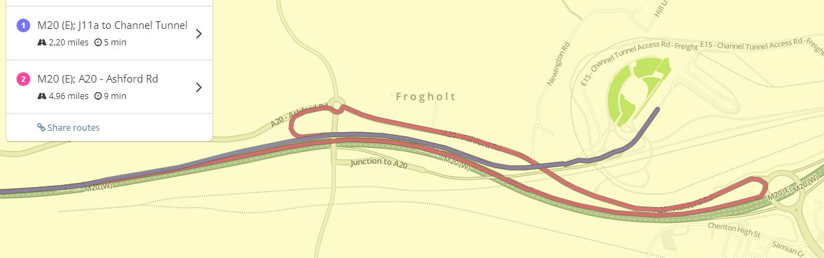
The purple route leaves the M20 and goes straight into the terminal. The red route continues to the next junction, exits, comes back along the A20 and then joins the purple route just south of the roundabout.
My initial thought was that the alternate was insane. However, looking at the times, maybe not. The direct route has a time of 5 minutes - quite long, I would have thought, to get into the terminal by a straight road. The red route is 9 minutes and I could see that it might only add 4 minutes.
I am guessing that there are often queues here. I certainly hear about queues into the terminal on local radio often enough. If Waze thinks that speed on the first exit from the A20 is fairly slow, then going around & back to bypass the first section of the ramp may not be as crazy as it sounds. If a Wazer had been caught in a temporar slowdown on the ramp a short time before, that might tip Waze into trying to bypass it.
There’s an additional problem - and one I can’t offer any solution to. It’s caused by the ramp being so close to the motorway (in real life). Waze was routing this driver down the motorway. Although he presumably went up the ramp and encountered no delays, it’s very likely Waze stayed snapped to the motorway. That means his good recorded speed would have been recorded for the motorway, not the ramp and would have done nothing to disabuse Waze of the notion the ramp was slow at the time. This sort of effect could be skewing the speed data for ramp & motorway.
Actually, the poxy things are all level 5 locked - but I accept it doesn’t matter how far out of your reach the cookie jar is.
If you’ve got any ideas how to fix this (because I haven’t), I’m happy to downlock anything for you.
Not going to lie, I had thought about the sliproad and motorway proximities to one another possilby causing this issue, I have it here on the Island where the A249 comes off and Waze sends people to the roundabout to do a left as opposed to the ramp. Again, proximity…
Not sure what can be done with this, I’m as stumped as you are mate
Would it not be easier to just lose all those small service roads and plop a big landmark for “EuroTunnel” and have Waze navigate to the gate. I’m sure people can follow the signs from there. As it is currently, it’s just confusing the hell out of the Wazers.
I’ve had a long hard look at the map, and think that yes; maybe it should be mapped up to the gates.
Currently there’s a bizarre mix of Streets, Service Roads (which is no different from Street), Private Roads (for the actual service roads) and Toll Roads (for freight), with several segments connecting to the railway.
If there’s a problem with destination pins, then it would be useful to gather some examples of searches that drivers type in. We’ll need to make sure that reasonable routes are provided to all the possible destinations.
As for the original routing problems, I’m not sure what we can do. If Waze genuinely thinks that the alternate route is quicker at certain times of the day, then it will route drivers that way. I’ve seen this occur elsewhere too.
I’ll be driving through there next month (for the first time evar!), so I can assess how it works then…
Indeed. Bits all over the place, and most of it locked beyond my measly L4 rights, otherwise I’d have deleted most of it by now.
Not too worried about the time of day thing, although it is probably exacerbated by all these other problems.
I’ll run a few searches and note what I can.
Shouldn’t the Tunnel in any case be shown as a toll road, as it indeed is from the French side until presumably no-one could edit any further mid-channel? In which case you would get routed through it, like my car sat-nav does. See the Lötschberg Tunnel as an example in Waze.
Considering the UK isn’t connected to Europe by any landmass, I don’t think there’s any need as such to mark a Toll. If you want to go to France, you’d be pretty thick to not know you’d have to pay  (unless you can swim or have one of those uber-cool James Bond underwater car-boat things)
The Tunnel is a Railroad not a road, so should not be a Toll as routing isn’t permitted anyway.
Hi,
What!!! You mean I’ll have to pay for my ferry over? Damn… 
Des. . .
I’m sorry to disappoint but we only let people in the country for free, not out. :lol:
Although the Welsh take the reverse approach. :?
My point was that that is how it is set up from the other end, if anyone can ever link them up,
https://www.waze.com/editor/?lon=1.75751&lat=50.93571&zoom=2&layers=935&segments=176633578&env=row
and that’s how the alpine car-carrying rail tunnels are depicted.