So I’ve had a roadworks issue in my local area that’s lead to an automated traffic signal being installed and a reduction to one lane usage flow control. This issue is due a subsidence situation has been going on for 6 months now and is easily forecast to go another several. Yet at the moment, despite arguments with a fellow more senior map editor who noted that ‘nothing can be done’ to get it properly marked for the period without say my own almost daily detailed flagging(cut and paste description and take a photo) in Waze as I travel through it. Conversely though, I was able to recently prove a permanent or semi permanent flagging can indeed be applied which I noticed while traveling through an area I regularly traverse which has a near identical issue with the only difference being landslip on to road as opposed to under road subsidence. So now I’m at truly at odds as to why one case can be handled properly and the other seemingly can’t in the Waze editor :roll: …
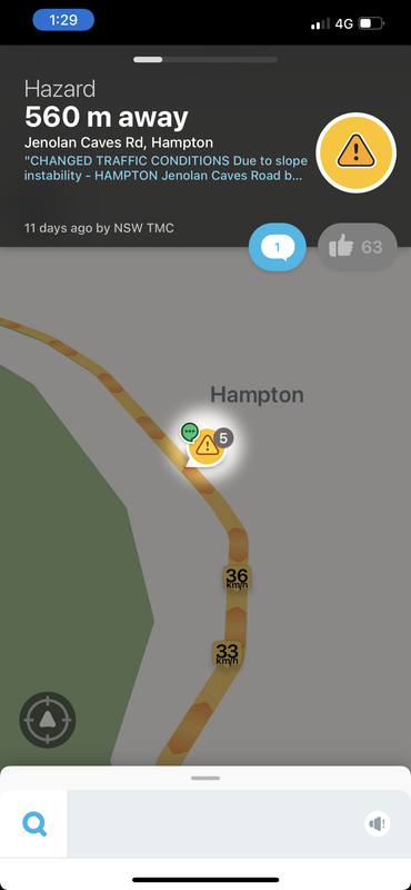
The (semi)permanent roadworks area (don’t have the manually flagged location snapshotted since it disappears in no time at all):
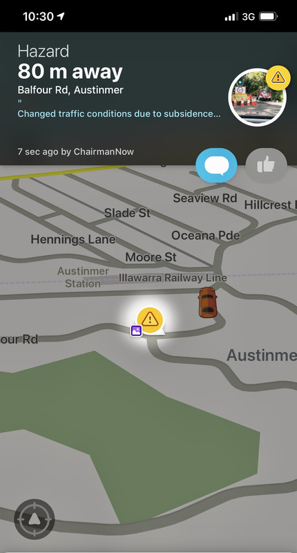
The manually flagged same format roadworks in my local area:
Assuming you have already posted in the Australian forum, and the senior editors you mention have already explained things, I’ll try provide some opinions from a UK perspective.
Hazard reports made from the application have an expiry period to prevent the map being littered with reports that never disappear. The exact time span they linger is not known but can be influence by other users, confirming the hazard extends the visibility period, while marking it not there will reduce / remove it. The senioritory of the user may also play a part in timings. The screenshot above shows 63 users have confirmed the hazard, extending its visibility.
If your report is located on a road that gets less traffic or users that don’t interact with the app, then there is little an editor can do, editors can only add full closures to the map. Editor can map hazards s these are done via the application. You describe 2-way traffic under temporary traffic light control, so the road is open in both directions.
In the UK we have an data feed that adds hazard reports of local authority works to the map that include known (expected) end dates, these therefore could be classed as semi permanent as they linger to the expected end date unless down voting removes them or users comment on them stating they are gone.
In any case, you have chosen the wrong section of the forum to post your message.
Before writing, perhaps you need to read and look for the right section.
This section of the forum is dedicated to events (sports, roadworks, VIP visits, shows …) that lead to road closures.
As they are asking to mark long term roadworks and you state this forum is for reporting events that include roadworks, it might not be a perfect place for this question but I can see when they chose this location.
Rather than just complain about where to post how about also adding some help or even a solution to their question.
As written above, there are national forums. Coordinators and senior editors from many countries have the ability to post alerts on the map.
That is the place to write.
In the Italian forum we have a section dedicated to these requests.
Thanks for your post. I’ve moved your post to the Australian forums
I hope the above replies have helped. We’d certainly like to be able to add a permanent hazard for you, but only Waze partners can do that - in your example the NSW Transport Management Centre. Even us senior editors can’t do that.
Ahh yeah thanks. Being a long time forum participant (on many enthusiast forums since the 90’s) the route Waze takes you here from the main web pages doesn’t mention localised forum subsections whatsoever I can assure you, so I didn’t expect go looking for it like I might normally do when I hit a forum board index (especially in the clunky old phpBB format being run here). I only stumbled upon this today upon coming back via the Waze website on a more obscure link that I can’t even find again…
I thank you for assisting with that. I will head over there and get stuck into it with the locals (should I say, it’s automatically cross-posting this anyway). That’s an excellent call in this particular case as I cannot see the NSW TMC (or RMS) getting around to the posting themselves on the issue, so a user submittable version would be just the ticket.
By way of update, I have now ascertained that these local roadworks that this issue stems from now will not conclude until the end of this calendar year at least, meaning well over a year of alteration in driving conditions to signal control alternating one way traffic flow. There was actually an issue today where the light were flashing yellow causing a further significant issue that I just didn’t bother to flag as I would have had to engage directly with the app itself and not the Carplay interface.
Meanwhile nothing at all has happened over at the editor suggestions page since I posted a detailed summary of the request… :roll:
Still seems to be no progress via the Map Editor Suggestions site. I’ve personal given up my manual hazard marking with description of the road segment as I’d been doing it for too long now.
I witnessed something a couple of weeks ago that demonstrated why such user road hazard markers should exist. I was traveling behind an uber driver (whom was obviously from outside the area), who completely ignored the automated stop light on this piece of road and very nearly ran straight into an oncoming car which just rounded the blind corner half way through it and had to reverse back some 30 metres. I know some uber drivers rely solely on the uber app, however I’ve also noticed plenty of drivers run waze in parallel specifically for the audible road warnings.
A major post script to this particular saga and living breathing example of just how ridiculous a situation it can be without this functionality in Waze (or Google Maps for that matter). As yet my well stated map editor suggestion has resulted in nothing unsurprisingly. Some 4 month down the track and I’ve understandably long since given up my manual cut and paste notification efforts for it. Today I have literally received written local council advice formally stating this roadworks and lane closure will not be completed until the first half of 2022. I now await our summer months when there is a literal guarantee of this back road being bottle-necked by idiot day trippers and out of towners trying to be smart thinking they’re avoiding the regular main road traffic jams caused by their brethren ascending on our suburb during weekends and holidays. Best I can do here is bring back my manual reporting of this roadworks and traffic flow issue in the hopes it does some good. It may well pay for me to do this on Google Maps itself in all honesty to increase the actual eyes on the issue at any given time.
I’m not sure if you’re aware, but the roadwork hazard reports do nothing for trip speeds or contribute to slow traffic reports. Waze collects and updates it’s database every time a car drives along there with Waze open. It remembers the travel times for every 30 minute block of time, for all 7 days of the week, and it differentiates holidays. The only thing a roadwork hazard report does is add a pop up that says roadwork ahead, which will expire if people don’t keep tapping the “still here” button in the app.
Waze partners such as Transport for NSW have automated systems that populate the map with longer hazards as required. If they haven’t deemed the works of big enough interest, our local editing community isn’t going to intervene.
Ahh yeah I’m well aware of this but thanks for pointing it out again. If you went back a page and refreshed yourself on the discussion, you’ll recall I’m on about allowing a user to semi-permanently flag a long term roadworks issue, adversely affecting traffic flow for people to see. I have no interest in it contributing to ‘trip speeds or traffic reports’ via this reporting. This is however extremely relevant for ‘out of towner’s’ who tend to depend on Waze (or Google Maps) to locate these back road ‘Rat Runs’ and where we will again, similarly to last summer see these avoidable traffic issues occurring in a residential area as a direct consequence of these driver’s route choices. To that very issue of the temporary nature of hazard reporting(and core of the issue itself), due to the ‘backroad’ nature of these particular roadworks, I’ve yet to see a single person on Waze manage to propagate it once by clicking the still here button (which would obviously somewhat mitigate the need for the feature request in Waze).
Yes, also well aware of this fact from the start going back to my first post where you can even see the tag in the attached screenshot ‘posted by NSW TMC’ and also my acknowledge in my reply from Mar 10 noting that and also as that Transport NSW aren’t going to be bothered or lack the granularity required in their automation to address the issue. We are all aware here in Aus how poorly State Govt departments and local government work together on such matters of course.
:
So in summary what I’ve said re the need for manual intervention until either, a) Waze miraculously adds this functionality I’ve suggest or b) Local council get these works completely and traffic flow returns to uninterrupted two way flow…
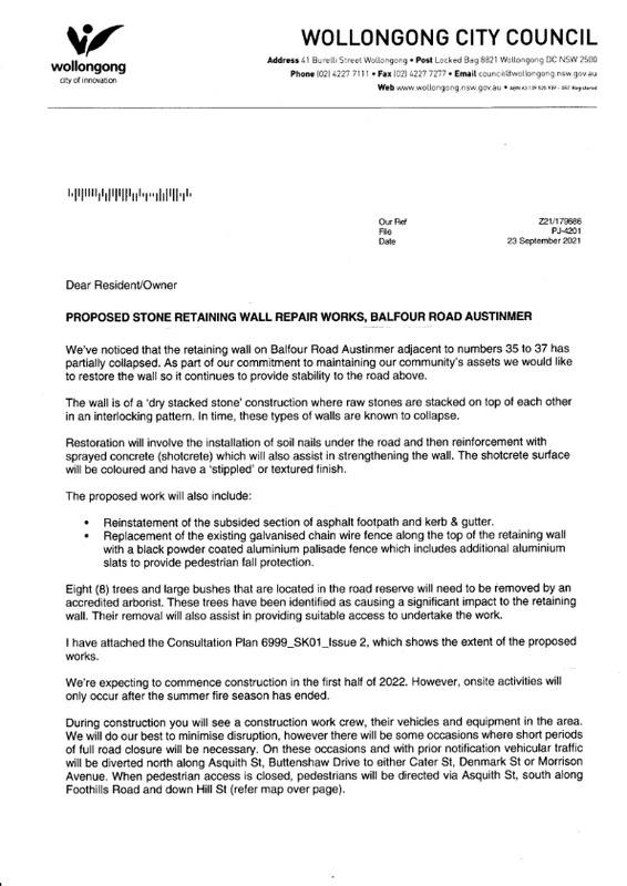
Lastly this is the actual notification from local council concerning the rectification with proposed further length of time until complete just so it’s known I wasn’t concocting a fake scenario here as my justification for the Map Editor Suggestion page.
And as I said on the previous page, I sympathise, however, there’s not a lot we as community volunteers can do. You’re welcome to continue posting long repetitive posts here but I suspect your time could be put to a more constructive use.
Why not try petitioning Wollongong city council to join the Waze for Cities program and upload all their closure and roadwork details there? They could also use the data exchange program to monitor for unusual traffic, such as queuing around the university.
From memory, Wollongong frustratingly hides their closure and roadwork details in a PDF document, which is only published a month after the traffic meeting has occurred. I have contacted them in the past asking them to improve their flow of information surrounding traffic works unsuccessfully.
Yeah I wasn’t specifically saying you were questioning any of the situation I’m referring to. It was more generally for anyone else reading or following.
Very valid point you make there and definitely goes to explain why the RMS wouldn’t be submitting anything
I’d love to follow up council myself but I barely have firm to check posts here. I was only reminded again today as I often am when I car already drive past the area. I witnessed the truly ridiculous Level of day trip traffic today in the last half hour. The regular spots are already well beyond a joke with cars backed up for hundreds of meters. I was able to post a manual hazard as I was not driving warning with details and warning to tourist traffic trying to shortcut through, which I am certain will lead to people attempting this.
A minor update for the new year. This fun little road situation is according to correspondence in the last couple of months , is due to be remediated sometime this Autumn, perhaps around March/April. Meanwhile, we’ve been spared any of the potentially chaotic traffic situations thanks to the very rainy and unwelcoming ‘La Nina’ weather over summer so far. Mind you if the forecast remains clear and warm tomorrow, this could change for this little area of roadworks. I wouldn’t be surprised though if the return to rain is correct and once again diffuses any potential issues. This could be the one time I’m actually thankful for the summer to have been so rubbish weatherwise!
Finally as of today works are finally to commence on to bring this stretch of road back to 2 way in approximately a months time. Let’s hope by the next time, if ever, there’s a way finally added allow longer term user added roadworks flagging.
A final post to say these works were completed at the end of last week. Through the period there were many great examples where they closed the road both ways and didn’t have any warnings, which definitely caused people, including myself some frustration of having to turn around and waste time. On a few occasions I was able to manually report the temp 4 hour closures, but at no stage did anyone else return the favour. At least that part of the system works a treat.
Let’s hope the if I ever have this kind of scenario come up again, Waze has a more useful reporting system for these kinds of part closure issues. Not holding my breath though and I’ve my done bit in Map Editor suggestions quite a while back.