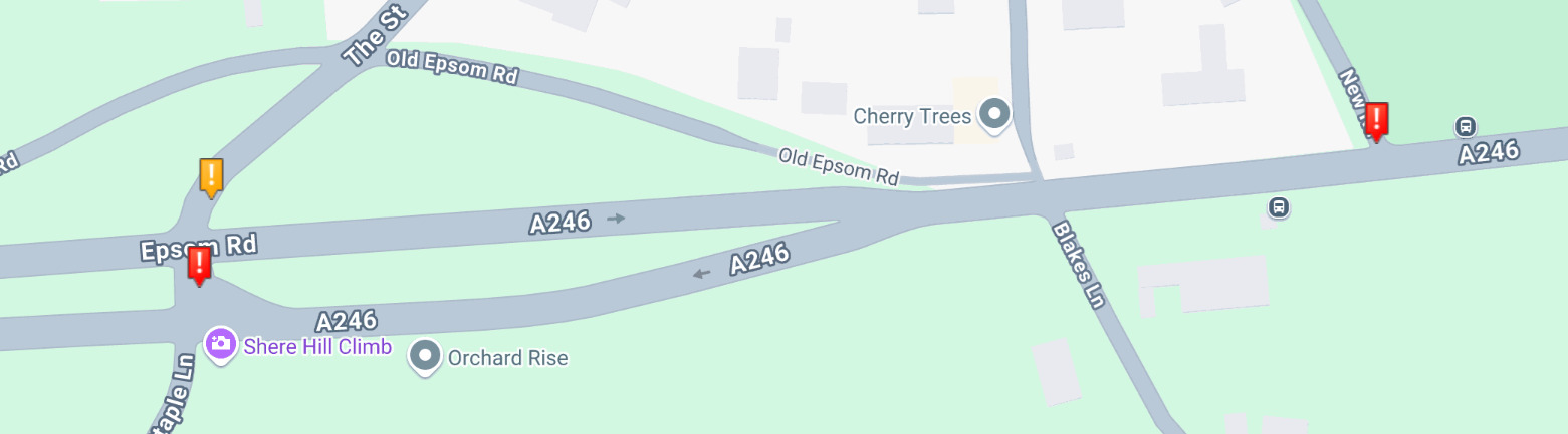
I guess this is a complex one as this road hasn’t been used much as the locals know the entrance / exit of the road where New Road meets the A246 in Clandon Surrey is a 50mph road with next to no visibility and there is a brow of a hill too,
https://waze.com/en-GB/editor?env=row&lat=51.25388&lon=-0.48137&zoomLevel=18&segments=121580185
There is a “proper” cutting and access for vehicles on The Street, this allows clear views in both directions and for vehicles to stop in the middle and not have other vehicles flying up behind them at 50mph.
https://waze.com/en-GB/editor?env=row&lat=51.25350&lon=-0.48257&zoomLevel=19&segments=121577741
This was never an issue until the nav apps thought that the other road was a few seconds quicker, there have been some nasty accidents with people pulling out of New Road onto the A246 and there are signs up on New Road stating that it’s not for through traffic.
I guess I’m asking for Waze to act upon this before the council are forced to reduce the speed limits on the road or close New Road…
It wasn’t clearly defined, so I presume this is in relation to westbound A246 traffic turning right up towards Ripley Road?
The main problem we have is that we can’t arbitrarily tell drivers not to go down what is a legal, valid route especially if that route is quicker and faster.
Here it sees a much quicker and direct route along New Road, and a very slow journey time along The Street. To say it’s a few seconds quicker is low-balling the time saving. This is more a factor of a minute to two. The junction at The Street has a lot of wait time compared to turning at New Road, which I would suggest is down to the give way line being positioned as to requiring drivers to allow a lot more time to clear the carriageway than required at New Road’s junction, and eastbound A246 traffic is more likely to slow down and gesture for a car to cross the junction at New Road than at The Street. It is therefore understandable why all automated systems identify New Road as the fastest and shortest route to take.
I don’t see any signs on the road from March 2025, are they newer than that? Checking Accident Statistics 2020-2023, the junction with The Street has a slightly higher accident rate than the junction with New Road.
If the council apply a “No motor Vehicles except for access” then we can update the map accordingly, otherwise as this is a valid highway route where drivers have the right to use the road, we can’t say on Waze that they are not allowed to use it.
I guess we’re talking about the difference of 0.2 miles, I have no issue with people being directed down these roads except there are plenty of people who cannot drive and panic at these roads, it’d be nice to have only those drivers removed from the roads 
The biggest problems I’ve seen are people turning right into New Road when there is a queue of traffic behind them not expecting people to stop on a 50mph road and then people turning left out of New Road with poor visibility of vehicles already present on the A246 meaning people have to brake hard.
Your comment to say that people will let others go into New Road never happens, people won’t slow down from 50mph in 100m that is all that is visible of the junction looking West bound
I guess this post was more to see if anything could be done to prevent near misses and accidents before something happened.
I have flagged the junction as “difficult turn”, this will mean those who have selected “avoid difficult turns” not receive navigation to turn right over the chevrons into New Road, and will instead route over to The Street, however this won’t stop the majority of drivers who don’t have that setting switched on, or fix the drivers on the A246 that may not be paying as much attention as they should on the road.
It’s important to note that Waze, and all other satnavs, are just aids to navigation and not a substitute for good driver behaviour, it sounds like this junction may warrant closer scrutiny by the local council and police if things are as bad as you suggest. There’s plenty more options available other than stopping up New Road or reducing speeds (although in the scheme of things, reducing speeds is usually picked first as it’s the cheapest option). The council would have done something similar 25 years ago when they changed the layout of The Street junction from two-lane to one lane eastbound in the early 00s. If the council do decide to make changes to this junction in so far as restricting vehicle movements, we can update the map on Waze to be in effect within a couple of days of notification of the change.