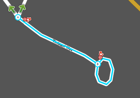
I’m currently finding a lot of places such as this: https://www.waze.com/editor/?lon=-1.09662&lat=50.84333&zoom=8&env=row&layers=389 , as it was : that turn back on itself, but are’t connected, so if you were at the wrong end of it you were directed to drive back down the road. (This is a bad example as the loop isn’t “long”, and it’s obvious where to go.)
What are people’s opinions and guidelines on fixing these as I have done, ensuring that the loops don’t result in duplicate paths between nodes?
I try and ensure that each node is where a turn in the road would be, so the number of data points is identical, but I can believe a geometry point and a node are not treated equal. In terms of CPU and data overhead for a route, i can imagine providing a route being a little longer/larger as the list of nodes to traverse increases by 2, but at least you should only ever have 2 of them ( one at start, one at the end)
Hi,
Personally I tend to just remove the loop if it is a small roundabout at the end, leaving a simpler road layout.
For larger roundabouts I will tend to fix the problem by splitting the road and making sure the ends are properly connected.
No idea if this is the same as other editors though.
I do believe there is a rule against actually terminating in a roundabout though; it is in the wiki somewhere but I can’t dig it up at the moment for some reason.
I knew there was something about cul-de-sacs on the wiki - thats’ the one i was looking for. So in theory, i should actually remove the loops entirely. That i can understand.
Do you draw the loop as the first picture, or as i’ve now changed that one to?
If the loop is small, straighten it out and leave the end of the cul-de-sac straight.
For larger loops you can split/add segments to the existing loop.
My rough guidelines: if there are more than about a dozen houses around the loop, or the loop has a building in the centre, or you can’t see across the loop, then I map it as a loop.
Important note, Waze can have problems navigating when 2 segments have the same start & end points. Because of this, any loop should be made out of 3 segments, not counting the one that leads off to the main road.
Useful tip. End loops should not be roundabouts. But you can start with a roundabout. If you have WME Toolbox installed, this includes a “convert roundabout to normal road” function that will save you a lot of time. Here’s one I made earlier. Failing that, you can still create a nice round loop by using a roundabout as a template: you then draw your own segments by snapping them to the roundabout, then delete the roundabout when you’re done. More details here where I explained how to do it once before.
This was actually the road I was referring to https://www.waze.com/editor/?lon=-1.34602&lat=53.00556&zoom=6&layers=741&env=row&segments=237895781 (this road is where the mum-in-law lives). When I joined waze a couple of years ago, this entire area was pretty much un listed, so I renamed pretty much every road within 6 miles of here and applied for and got local AM status, which has gone, but that’s another issue.
I’d drawn it the same way, apart from the duel split, as dknight has here.
Yeah, i started out trying to fix all the duplicate nodes that were in my area, which brought be on to these, which i’m now looking at.
I think it would be very useful to have the following in the UK wiki regarding roundabouts.
My rough guidelines: if there are more than about a dozen houses around the loop, or the loop has a building in the centre, or you can’t see across the loop, then I map it as a loop.
 that turn back on itself, but are’t connected, so if you were at the wrong end of it you were directed to drive back down the road. (This is a bad example as the loop isn’t “long”, and it’s obvious where to go.)