
This page is a supplemental mapping resource page for editors of New Mexico. All guidance specific to New Mexico can be found in the Southwest region wiki. Other states in the Southwest region include Arizona, California, Colorado, Hawaii, Nevada, and Utah.
To get in contact with the Southwest editors please use >> this link << to join the Southwest Region Editors on Discord. Discord is the primary communication platform for Southwest editors.
If you have questions about this page or it needs updating please visit [Page update] Southwest Region (SWR) Wiki and reference this page, New Mexico Mapping Resources.
Mapping resources
Federal & Tribal Resources
- Navajo Nation, Department of Transportation
- Navajo Nation Regional Routes
- US DOI, Bureau of Indian Affairs (BIA) Transportation
- Pueblo of Jemez Road Map ArcGIS
US Bureau of Land Management (BLM)
State Resources
New Mexico Department of Transportation
- nmroads.com
- NMDOT Interactive Maps
- NMDOT Functional Roadway Class
- NMDOT Roadway Inventory Program (index of numbered highways) Links below Legal Routes Descriptions are to PDFs, and they are very informative.
- NMDOT Projects
- Press Releases (useful to see road closures)
- Rest Area status (open or closed)
- Rest Area Handbook (available facilities)
City Resources
- Alamogordo Road Closures
- Alamogordo ArcGIS
- Albuquerque Advanced Map Viewer
- Albuquerque Road Closures
- Carlsbad PDF Street Map
- Farmington Road Closures
- Gallup Roads and Addresses ArcGIS
- Gallup Road Closures
- Las Cruces Road Closures
- NMSU Campus Road Closures
- Las Vegas ArcGIS
- Rio Rancho PDF Street Map
- Rio Rancho Road Closures
- Roswell Road Closures
- Santa Fe GIS ERSI
- Santa Fe Road Closures
- Taos Zoning Map 2020 PDF
County Resources
- nmcounties.org The 33 Counties of New Mexico
- Bernalillo County Address and Zone Map ArcGIS System
- Catron County Overview Map PDF 09/09/24 (large file)
- Cibola County Parcel Map Portico
- Curry County Roads
- Dona Ana County Map *The largest city is Las Cruces
- Dona Ana County Street Atlas 2010 Edition
- Eddy County Maps PDFs
- Eddy County Road Closures
- Lea County Parcel App ArcGIS
- Lea County Road Closures
- Lincoln County Parcel Map Portico
- Los Alamos County Parcel Viewer ArcGIS
- Los Alamos County Road Closures
- Luna County Parcel Viewer ArcGIS
- Otero County Road Maps PDFs
- Rio Arriba County ArcGIS
- Roosevelt County Parcel Viewer ArcGIS
- Sandoval County Tax Parcel Viewer ArcGIS
- Sandoval County 2021 Road Inventory PDF County Road Certification 3/18/21
- San Juan County Assessor’s Map *The largest city is Farmington. County maintained segments CR-#### have yellow numbers on blue. Road #### segments are not maintained by the county and signage have red numbers on white.
- Santa Fe County Tax Parcel Viewer ERSI
- San Miguel County Parcel View ArcGIS System
- Sierra County Parcel Viewer Axiom
- Taos County Address Finder ArcGIS System
- Torrance County Portico
- Union County Maps County and Town PDFs *The largest city is Clayton
- Valencia County Assessor Parcel Map ERSI
Functional Classification
New Mexico is following the Functional Classification (FC) system for the USA.
NMDOT to Waze Functional Classification conversion
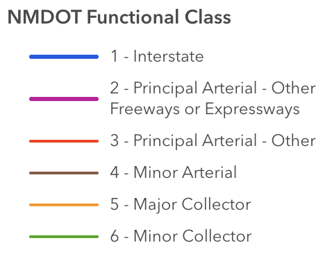
The New Mexico Classification and Color scheme comes from the official New Mexico D.O.T (NMDOT) Functional Classification (FC) map that is published by NMDOT. The legend shows what classifications NMDOT uses and what color is assigned to each class. The actual interactive State Map can be found here:
NMDOT to Waze conversion table
Deviations from FC
- Longer rural roads classified as “Major Collector” on the FC map should be set to Minor Highway (mH) rather than Primary Street (PS) to avoid pruning of valid routes.
- State highways that are classified on the State FC map as “Minor Arterial,” but are dirt/gravel, should be set to Primary Street (PS) and have the unpaved box checked, instead of Minor Highway (mH) .
- SR-26, Hatch NM to Deming NM, is set to Major Highway (MH) to allow routing from I-25 south to I-10 west and bypass Las Cruces.
- Several non-Interstate highways in New Mexico are mapped as Freeway (FW) because they are constructed to Interstate standards:
- 11 miles of US-70 in the Las Cruces area.
- 12 miles of US-84 in the Santa Fe area.
- 5 miles of Paseo del Norte (SR-423) in Albuquerque.
Closures
Major Construction Projects
See New Mexico DOT for a list of road closures & changes to traffic flow that impact the Waze map. Only long-term construction projects should be addressed.
Road Closure Alerts
The website nmroads.com will list closures on a map. You may also sign up for text message that describe road closures as they occur.
Roads
The former US-66, now known in many parts of the state as “Historic Rte 66”, “Old US-66” or similar derivatives, is no longer a commissioned US highway in New Mexico. The US route shield is not used.
Special roads
- Indian Reservation Roads: Native American Indian reservations have jurisdiction over their own roads, although certain federal, state, and county roads can cross their lands. Before you edit on these lands you should be familiar with this Wiki page.
- Forest Service Roads: New Mexico and many states in the USA have US Forest Service Road systems that have their own functional classification and rules. Before editing on these roads and associated landmarks, consider this Wiki page.
- Bureau of Land Management Roads: New Mexico and many western states in the USA have Bureau of Land Management (BLM) roads that have their own standards. Before editing on these roads and associated landmarks, consider this wiki page. BLM also manages certain National Monuments.
- National Park Service Roads: While not significantly different from normal roads, you should consult this Wiki page before editing these roads and their associated landmarks.
- Military Bases & Government Installations: New Mexico has a large number of military bases and National Laboratories that have restricted access. Please follow the Private Installations article when mapping these facilities.
Cities and towns
Duplicate cities can be caused by incorrectly named segments and should be corrected following the guidelines in the duplicate cities article.
These are the known cities with duplicate city names in New Mexico:
-
Arroyo Hondo
- West of I-25 in Santa Fe County, name the city “Arroyo Hondo (Santa Fe Co)”
- On SR-522 in Taos County, name the city “Arroyo Hondo (Taos Co)”
-
Broadview
- On SR-605 in Cibola County, name the city “Broadview (Cibola Co)”
- On SR-209 in Curry County, name the city “Broadview (Curry Co)”
-
La Cueva
- On SR-518 and SR-442 in Mora County, name the city “La Cueva (Mora Co)”
- On SR-126 in Sandoval County, name the city “La Cueva (Sandoval Co)”
-
La Madera
- West of SR-14 in Sandoval County, name the city “La Madera (Sandoval Co)”
- On SR-114 in Rio Arriba County, name the city “La Madera (Rio Arriba Co)”
-
Placitas
- On SR-26 in Doña Ana County, name the city “Placitas (Doña Ana Co)”
- On SR-165 in Sandoval County, name the city “Placitas (Sandoval Co)”
-
San Jose
- On US-84 in Rio Arriba County, name the city “San Jose (Rio Arriba Co)”
- On I-25 in San Miguel County, name the city “San Jose (San Miguel Co)”
-
San Ysidro
- West of I-25 and US-70 in Doña Ana County, name the city “San Ysidro (Doña Ana Co)”
- On SR-4 in Sandoval County, name the city “San Ysidro (Sandoval Co)”
-
Torreon
- On SR-197 in Sandoval County, name the city “Torreon (Sandoval Co)”
- On SR-55 in Torrance County, name the city “Torreon (Torrance Co)”
-
Valencia
- On I-25 in Santa Fe County, name the city “Valencia (Santa Fe Co)”
- On SR-47 in Valencia County, name the city “Valencia (Valencia Co)”
Cameras
- Red Light Cameras are legal in the State, but Illegal in the City of Albuquerque.
- Speed cameras are legal in the State and are in use in Bernalillo County, including the City of Albuquerque. A list of Albuquerque speed cameras is available here.