New Hyperlocal Permanent Alerts are now available in WME Production

Hi everyone!

We are pleased to share that we are launching a new set of Permanent Hazards in WME Production for the LatAm, Brazil, and APAC communities. While this initial release is intended for specific countries, the next phase will expand to the rest of the world based on continuous feedback from the communities and data collected and analyzed from the future release of these features in the app.

Why new Permanent Hazards?

We are improving the Waze map to offer drivers an even more local and contextualized experience, focusing on specific road infrastructure risks that impact traffic safety.

These new alerts are designed to increase drivers’ situational awareness, helping them identify changes in the road with more lead time and confidence, contributing to even safer navigation.

What is included in this WME release?

It is now possible to map five new types of Permanent Hazards. They are added as point-based hazards directly onto a segment. We have prepared a detailed guide to help you get started.

:right_arrow: Check out the editing rules HERE

The 5 new types of Permanent Hazards

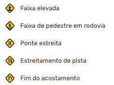
  • Raised crosswalk: Raised crosswalks in platform format.
  • High speed crossing: “Zebra” style crosswalks located on high-speed roads, with a higher risk for users.
  • Narrow bridge: Single-lane bridges on two-way roads, where vehicles need to slow down or yield.
  • Lane end - abrupt: Early warning for lanes that end abruptly, requiring merging into traffic. This alert is visible only for the motorcycle vehicle type in the app.
  • Shoulder end - abrupt: Early warning for locations where the shoulder ends abruptly. This alert is visible only for the motorcycle vehicle type in the app. (Currently disabled for Brazil.)
Safety for motorcyclists and expansion to other vehicles :motorcycle:

For the first time, we are introducing Permanent Hazards with a special focus on protecting the motorcyclist community. Two-wheeled riders face specific risk situations, where a few seconds of warning can make all the difference.

The Shoulder end - abrupt and Lane end - abrupt alerts were created specifically to help reduce these risks, allowing motorcyclists to avoid situations where they might run out of space due to surrounding traffic or be surprised by the sudden end of a lane.

We also want to acknowledge the feedback received during the Beta phase, where many community members highlighted that these alerts are also extremely relevant for drivers of other vehicle types. The team is already working on this and expects to make these alerts available to all drivers in the near future.

Editing Guide and regional adaptations

Although we have prepared a comprehensive global editing guide, we rely on local communities to adapt it and create versions that best reflect the characteristics, needs, and particularities of each region’s infrastructure. Remember to continue following global recommendations on which situations should or should not be mapped.

Next steps

On July 1st, the gradual rollout of these features will begin in the production app for users in APAC, Brazil, and LatAm. Before this date, the alerts will NOT be visible, so please be careful not to disrupt the user experience. This will allow us to analyze the entire feature cycle, from mapping to the actual driving experience.

UNTIL THE RAISED CROSSWALK ALERT IS LAUNCHED IN PRODUCTION IN THE APP, WE RECOMMEND NOT REPLACING EXISTING SPEED BUMP ALERTS IN THESE LOCATIONS. SPEED BUMP RULES ARE BEING REVISED AND WE SHOULD PUBLISH A NEW UPDATE SOON!

  • For those editing in APAC, Brazil, or LatAm: We need your help! To ensure a successful app launch on July 1st, we need to build a solid data foundation. This means these hazards need to be mapped before they start being made available to users. Please coordinate with your local community leadership to begin mapping these hazards in WME.

  • How this impacts the global release: The data obtained during this initial phase will directly influence the global expansion schedule for the feature. The team will closely monitor driver interaction metrics to evaluate the utility and effectiveness of these alerts.

If you want to see these alerts working in the app before July 1st, we recommend joining the Beta App community, where you will be able to see your mapped hazards in action.

Future phases: Segment-based Permanent Hazards and Weather Conditions

We are exploring new types of hyperlocal Permanent Hazards for future implementations. The next steps include:

  • Segment-based alerts: Expanding the current concept of isolated points to allow mapping of risk areas along a stretch of road (such as roads with steep inclines and declines or streets without public lighting).

  • Weather-based alerts: Integration with meteorological data to display alerts only when certain conditions are present (such as roads prone to flooding, potholes that accumulate water, or stretches that become excessively slippery when wet).

We are excited to make these new alerts available to the community and look forward to seeing them enriching the map soon.

Sincerely,
By: Danit

Original topic in English

A notice has been added to the topic:

On July 1st, the gradual rollout of these features will begin in the production app for users in APAC, Brazil, and LatAm. Before this date, the alerts will NOT be visible, so please be mindful not to negatively affect the user experience. This will allow us to analyze the entire cycle of the feature, from mapping to the actual driving experience.

UNTIL THE RAISED CROSSING ALERT IS RELEASED IN PRODUCTION IN THE APP, WE RECOMMEND NOT REPLACING THE EXISTING SPEED BUMP ALERTS IN THESE LOCATIONS. SPEED BUMP RULES ARE BEING REVIEWED AND WE SHOULD PUBLISH A NEW UPDATE SOON!

Some of the best news of the year!
Separating the categories of speed bumps and raised crosswalks even helps with pedestrian safety!
:children_crossing:

In the Portuguese editing guide, section “Difference between Lane Merging and the new Lane Narrowing alert,” subsection “Lane Merging,” the translation for situation (2) from the original English guide was not included:

“(2) Multiple lanes converging into fewer lanes with no clear main lane, causing a bottleneck effect.“

Thanks for the observation @Augusto_NH, this point is being reviewed by the Champ group for a possible adjustment to the local rules.

We should have an update to the official publication on our Wazeopedia soon.

All this evolution of Waze is awesome.

:clap:t5::clap:t5::clap:t5:

Thank you! I want to clarify this exact point very clearly, as it is quite common to confuse “lane” and “roadway.” And this is essential for us to use both alerts correctly.

TRAFFIC LANES – any of the longitudinal areas into which the roadway can be subdivided, whether or not marked by longitudinal road markings, which have a width sufficient to allow the movement of motor vehicles.

ROADWAY – the part of the road normally used for vehicle traffic, identified by separating elements or by a difference in level in relation to sidewalks, islands, or medians.

P.S.: What a struggle to make a simple reply on Discuss. It doesn’t allow you to paste unformatted text here with Ctrl + Shift + V. Instead, it pastes with different formatting and makes the text difficult to read after it’s posted.

(Below, just a test of Ctrl + Shift + V):

 TRAFFIC LANES – any of the longitudinal areas into which the roadway can be subdivided, whether or not marked by longitudinal road markings, which have a width sufficient to allow the movement of motor vehicles.
 ROADWAY – the part of the road normally used for vehicle traffic, identified by separating elements or by a difference in level in relation to sidewalks, islands, or medians.

MacBook test (shift + command + V):

    ROADWAY – the part of the road normally used for vehicle traffic, identified by separating elements or by a difference in level in relation to sidewalks, islands, or medians.

I think I’ve isolated the problem: Discuss is including this formatting when the pasted text starts with at least four spaces.

Ctrl + Shift + V is working correctly here.

Great job, Augusto; in this quick video, you can understand the difference between road, carriageway, and lanes even better:

I would suggest that instead of having 2 alerts in the menu, namely Speed Bumps and Raised Crosswalks, there should be only one “Speed Reducer” alert type. When adding this alert, after clicking it, we would have to select what type of speed reducer it is. By default, it would be Speed Bump, but we would have these 3 options available: Speed Bump, Raised Pedestrian Crossing, and Dip. This way, you wouldn’t need to delete the speed bump alert later to add a raised crosswalk alert in the same spot, as many of the speed bumps added in urban areas are actually raised crosswalks. And we would still have the much-needed Dip as an option, which is a type of speed reducer without signage.

Excellent point! Here in Brazil, depressions — commonly known as ‘valetas’ — are very common, and many of them are far from smooth to drive over; in other words, alerting drivers to them provides an extra layer of safety.

For these suggestions to be considered by Waze, you need to submit your suggestion through Waze Uservoice.

After creating the suggestion, you can post the link in the Brazil Community Suggestions Hub thread so that other editors can vote and make the suggestion relevant for review.

Thanks! I created the suggestion and posted it in the specified topic.

Good morning!

I suggest we map all the crosswalks located in School Zones. I see it as an extra layer of safety, as a crosswalk is a specific point of information within the school zone.

What do you guys think?

I’m not sure if I understood correctly, can you explain the idea a bit better?

There’s already a speed bump alert and raised crosswalks are coming soon. When there isn’t a school zone alert, these alerts appear again; are you suggesting a new alert?

Hello @aldo_rezende,

Pedestrian crossing alerts have been recommended only for certain roads that pose a higher risk to pedestrians. It is possible that, in the future, we will have a new type of alert aimed at pedestrian crossings in general.

At this moment, we need to follow the staff’s guidance and avoid mass mapping until the Champs decide to regionalize the guidelines according to the country’s reality.

Is everything released yet?

Hello @marxmr, due to the testing and rule validation phase by the community leadership, these alerts are still in beta and are being released gradually. We have an update planned for next week where we will release the local rules on Wazeopedia so that everyone can map correctly.

Until then, editors participating in the Beta community can follow the status of the features in the topic below:

Waze Feature Status

That’s right @GabiruX, I’d like to take this opportunity to reinforce Waze’s global guidance on avoiding excessive alerts, which can harm the user experience:

“We want to reinforce the importance of using permanent alerts with common sense. Excessive mapping can cause alert fatigue, reducing the effectiveness of these safety warnings. Please follow community guidelines to ensure that alerts remain useful and impactful for all Wazers.”

I am moving these posts to the feature topic to centralize the discussion in the correct place.


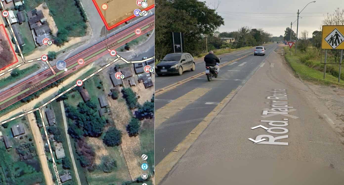
In this case, it is a state highway with a pedestrian crossing within a school zone.
Is this a good example of a case for mapping the Pedestrian Crossing on Highway alert?
Or since it is a school zone, would it be unnecessary?