Perhaps it is only available on the original (Android) version of the app. It is accessible from the menu.

Perhaps it is only available on the original (Android) version of the app. It is accessible from the menu.
Ah. Now I follow. The Memo layer IS part of the House Number Extension in WME, but only loaded through the House Number App.
The same way the house numbers are only loaded through the app. The layer in WME is a display feature for content in the email string, which in turn is produced by the app.
Request for modification:
Today, I was wanting to add house numbers to a brand new subdivision that does not even appear on the aerials.
So I drove down the first street and parked (I have mapped these streets in Waze) and opened the Android app.
The app is apparently searching Google results, because it was pulling up streets that were some distance away, and did not bring up any of the streets I had mapped.
This brings us to the second problem…
It will not allow input of any house numbers on streets that do not already have at least one address input (in the Google database)
I was standing on a road that I had added to the map, which included some addresses that I had added from my first trip to the area… but I could not use the app at all to add any addresses.
Can the app be modified so that it ignores the street and simply drops the house number we input onto the GPS coordinates? The data in the email contains the GPS coords as well as the city, state, and street number, but the only two things that are used in WME are the coordinates and the number that we input.
It would have been so much easier than pulling out pen and paper and manually drawing the roads (for the 2nd time, first time was when I paved it to write down the street names) and adding the house numbers to them.
This may not be a big issue in urban areas or older areas that are built out, but here in my area, new housing subdivisions are opening every month and none of their data is on Google.
Even the nearby streets that the app was pulling up did not have address data.
As you said, as it’s not used anywhere, if you don’t need it to remember it later yourself, you can use any fake/wrong data provided by geolocalization provider in the City and Street field, as long as they are not empty. What’s the problem with this?
The city/street fields were not empty… they picked up a nearby street (assuming from Google), but it would not allow me to input ANY address markers. The “Store HN” button was greyed out and it said that no HN’s were registered for the street.
This is a shot of the default screen before it gets a GPS lock, but the only difference is the city and street are solid black rather than grey (and GPS accuracy was 5m).
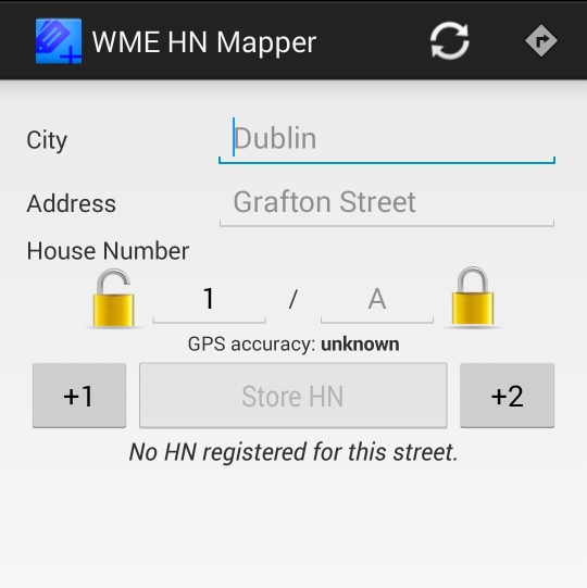
Or are you saying that the buttons will be activated if I manually input “7000 - 9000 Copper Sky” on the street entry?
Seems that Google not having addresses assigned to the street is what’s causing the issue.
Of course, local and Dev testing of this is difficult if you don’t have ready access to a street with no Google address pins.
Ok, I got what is the bug, when you open the application and you already had the GPS fixed it doesn’t work. I’ll try to fix that, in the meanwhile either you start the app with the GPS switched off or when it happens try to switch the GPS on and OFF it should work.
If I open the app with the GPS off, it asks me to turn it on. If I say no, it shuts down.
It had no problem getting the GPS fix, it popped up quickly and refreshed every time I hit the refresh button.
The issue is that it is searching Google (or Bing?), rather than Waze, for the street that you are on.
In my case, I was in the middle of an empty field on Google/Bing, so the app grabbed the nearest street.
And of course, that is not a big deal because I can manually input the street name for later reference in the email if I’m doing a group of these.
But since the street did not have any addresses registered in Google, the app did not allow me to input any addresses.
The bottom part of the image above is exactly how my screen appeared, but I had a valid city and street name and 5m GPS accuracy on the top part. It would not allow me to store a house number.
Here is a PL to the area I was mapping:
https://www.waze.com/editor/?env=usa&lon=-117.56364&lat=33.95882&layers=1605&zoom=5
https://www.google.com/maps/@33.9588821,-117.5650251,17z
http://binged.it/ZzwDIx
Depending on where I was, it was picking up Jack Rd, Orange, Cleveland, or any of the other surrounding streets (and interesting that it appeared as Corona because this area has been incorporated as Eastvale since 2010, Google is WAY behind and Orange does not even exist).
It looks like I may be wrong on Google lacking address information for those streets… spot checking Jack and a few others and I see that Google does show addresses… are you perhaps using Bing?
Either way, I had no way to input an address. The GPS fix was working perfectly.
I updated the app, try if this new version “works” (=at least lets you input the numbers).
How long will it take for the update to show on the Google Play store?
Edit: Got the update and it’s working fine now.
I was able to use a GPS spoofing app to move my location back to the area I noted and I verified that it did not work before the update, but it did work after the update, and the emailed coordinates matched the spoofed location.
Thanks a bunch!
Thanks you for reporting the problem!
This is now extremely useful.
We have a bunch of areas from the address import where the entire housing tract addresses were stacked on one stop point, and this program was good for those since we had registered HNs on those streets, but just within 10 miles of me, we’ve had probably 10 square miles of dairy land developed into housing projects. Many were begun in 2006 and work came to a screeching halt in 2007/8 when the market crashed.
They have restarted nearly all of these projects and the reps that I have talked to working the models are indicating that they are at nearly 100% occupancy within a month of the first move-in date on a newly opened phase.
That’s a LOT of new roads and a lot of new addresses for which we will likely never get another automated import. This is going to be an indispensable tool in getting these areas mapped.
Hi,
I am not able to see the “Show HNs” link in botton right of WME (only chat icon there…)
i followed this:
1 - Did you send the email from the application?
2 - Did you install the tampermonkey extension on Chrome?
3 - Did you install the House number script on tampermonkey?
4 - Did you click on the “Show HNs” link that will appear on the bottom right corner in the editor?
5 - Did you paste the string you got on the email?
but i am stuck at step 4…as not link in WME, now…
any clue?
thx
Hi, it still works for me both in production and wme beta. Maybe you have some other script installed that goes in conflict with mine?
hum…did uninstall ALL my extensions…did restart chrome browser ==> still not ok
Then uninstall WME HN , then Re installed it…==> now ok…
hard to understand…but now working.
thx…will now give it a try.
bye
Hi !
I’ve already heard of your script but without using it.
Now, it’s done 
It’s perfect and works fine but could you improve it to add POI ?
I’ve got a lot of industrial areas around me and I would like to create (at least) name of POI for companies.
Is it possible ?
Thanks.
Is it possible with the notes feature? Add a new note for each POI
Sent using Tapatalk for Android
Yes, it works but I’m a little bit lazy :mrgreen:
If POI could be created automatically on WME it would be perfect !
And house numbers too…
You can create POI directly from the app using Report > Place